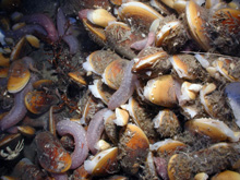
A close-up mussel aggregation with Chirodota heheva sea cucumbers. Click image for larger view and image credit.
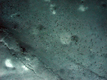
Lake Eerie seemed like an apt name for this location. The sea floor was dotted with tiny tubeworms and polychaete worms (visible as small black specs in the image). Click image for larger view and image credit.
The Red Crater
July 3, 2007
Ian MacDonald
Texas A&M – Corpus Christi
26°23.42 N
94°30.58 W
![]() Watch scientists use the "Bushmaster Jr." sea-floor community-characterization sampling tools. (Quicktime, 2.2 Mb.)
Watch scientists use the "Bushmaster Jr." sea-floor community-characterization sampling tools. (Quicktime, 2.2 Mb.)
![]() A typical mussel pot collection helps scientists understand deep-water mussel aggregations. (Quicktime, 1.8 Mb.)
A typical mussel pot collection helps scientists understand deep-water mussel aggregations. (Quicktime, 1.8 Mb.)
On July 2 and 3, we had been working at a brine pool at 2,200 meter (m) depths. The pool measures about 140 x180 m and is filled with concentrated brine, dark blue in color and full of flocculent (wool like) fragments of grayish white barite (barium sulfate mineral). The "shore" of the pool is coated with barite and looks for all the world like a white sandy beach — especially when the Jason remotely operated vehicle (ROV) approaches and pushes ahead of it a bow "wave" of the dense brine. The wave washes in and breaks over the beach, inundating the sea urchins and amphipods (small crustaceans) that live just beyond the rim of barite.
With our work at this pool was largely done, we had some time before the next dive — our last dive of this expedition. Eric Cordes had looked at the geophysical survey charts of the area and noticed a very large and distinct bull’s-eye about 2 or 3 kilometers south of our position. With a bit of time to spare, why not go explore? After discussing our plan, the Jason ROV went into tow mode and we made our way south at (for Jason) the warp speed of 1.5 knots.
Jason arrived at the feature in the afternoon just as a pyrotechnics demonstration was taking place on the fantail. Perhaps in anticipation of July 4, the crew of the research vessel Ronald H. Brown brought out boxes of rockets and smoke bombs, and showed us how we could fire these gadgets off in the unlikely event that we should find ourselves bobbing in a life raft with a desire to signal our position. Against the excitement of all the bangs and whooshes and clouds of smelly smoke, the news that Jason had found “a really big brine pool” did not at first arouse much interest. But then, one by one, the scientists began disappearing into the control van until the small, dark space was packed with over a dozen spectators, craning their necks to see the monitors. This was really cool!
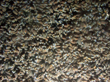
Jason was following a slightly curving shoreline, deep blue on one side and white on the other. There were white flocs (aggregations of fine suspended particles) floating in the brine. It was like the shoreline of the previous brine pool, except much bigger. It seemed the Jason just went on and on. Then the shoreline began to break apart into a series of channels and pools. The pool edge became much less distinct and we began to see patches of mussels. At first there were little clusters of 10 or 20 animals, some on tussocks (clumps) of high ground, others seemingly submerged in faintly shimmering brine. Then the clusters began to merge together into mats, carpets, tapestries, bowling alleys, football fields! Jason flew along completely surrounded in every direction. The mussels were stacked on end and layered completely covering the bottom. You could see their siphons pumping amid diaphanous veils of translucent mantle tissue. There were millions and millions of mussels! And scurrying among the mussels were shrimp, snails, amphipods, pink sea cucumbers, fish. . . . Everyone in the van was shouting and pointing and shaking their heads.
After taking a closer look at the autonomous underwater vehicle (AUV) data, scientists spotted another geological target of potential interest. The late amendment to the dive plan paid off when footage of this mussel "carpet" came into view. They discovered what is probably one of the largest-known mussel beds in the deep Gulf of Mexico. Click image for larger view and image credit.
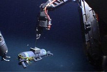
The Jason group fabricated this Niskin bottle, which can be lowered into the brine pool and triggered to collect a water sample — without disturbing the delicate interface. Click image for larger view and image credit.
Dinner came and went. Jason continued to circumnavigate the crater. The inner crater, which was all we had time to explore, was 280 m across. In the survey data, the circling rim was quite distinct. On the bottom and steering by video (that shows only vague shapes and shadows a few meters ahead), we found it difficult to follow the edge. We left Mussel City behind. It seemed to curve off along what might have been a broad series of outflow channels, veering away to the west. We drove out of it to the south, but we never saw its limits to the west.
When we eventually finished the circuit and other collections, Jason ventured out into the center of the crater. We thought that this feature, like the smaller brine pool to the west, would be full of fluid across its surface. Instead, in the area just beyond the shore with mussels, the brine "dried up" and the bottom became extremely rugged, with folds and ridges in chaotic array. The bottoms of the folds were lined with dark blue-black sediment. The ridges were light gray with snail trails and occasional fish. Eventually, we crossed the ridge zone and reached the central 50 m (or so) of the crater.
Now the sea floor changed abruptly, becoming much more level and even. Instead of blue-black and gray, the sediments were chalky white. Then we began to see streaks of a creamy red material. Soon the red matter coalesced, and the white material became the streaks. The bottom was perfectly level, appeared solid, and was teeming with swarms of amphipod-like animals that skimmed its surface. It was unlike any sea floor any one of us had ever seen. We kept straining for comparisons — like Mars, like a desert, like the Moon — and coming up empty. Fact was, it was so new and different that there were no fitting metaphors.
Our task was to collect sediment cores of the briny sediment. Matt the pilot gingerly brought Jason to the bottom, being extremely careful not to stir up a silt cloud. We selected a bright red patch and eased the core into the sediment. The core eased into the red layer without resistance and down to 30 cm, then it seemed to hit a hard bottom. When Matt pulled it out, there was a big cloud of mud as well as mud coating the tube. It was impossible to tell if we had a sample. I thought the mud had slipped out. We tried several more times. Eventually, we decided to try coring with a Niskin bottle — a device really intended to collect water samples. It, too, is a tube, but one that is sealed on both ends, when two stoppers are pulled together by rubber tubing running inside the cylinder.
We eased the Niskin into the red muck and hit the trigger. The stoppers snapped shut, and we had a sample of red stuff.


