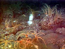
The white sponge in the center of this image is surrounded by reddish crinoids attached to boulders at a depth of 160 m. Crinoids are primarily seen attached to the substrate, but are occasionally observed swimming close to the sea floor. Click image for larger view.

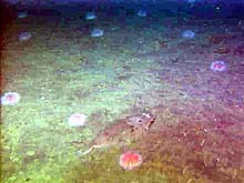
A Dover sole lies on the muddy sea floor (290 m) beyond the shelf break, surrounded by pink sea urchins. The sole's colorations mask its presence by blending with the surrounding sea floor. Click image for larger view.
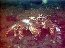
A box crab scrambles across the cobbles near the top of the southern bank at a depth of 140 m. Click image for larger view.
Heceta Bank: Where the Rockfish Roam
July 5, 2001
Susan Merle, Geological Research Assistant
Cooperative Institute for Marine Resource Studies Program, Oregon State University
Vents Program, Pacific Marine Environmental Laboratory, NOAA
and
Curt Whitmire
Cooperative Institute for Marine Resource
Studies
Oregon State University
ROPOS Dive R604, the remotely operated vehicle's (ROV) second on Heceta Bank, started in an area about 8 km northwest of the previous dive, which took place early yesterday. The main objective of this dive was to conduct quantitative fish transects near historical Station 6. All in all, eight 20-min fish transects were completed, the first one starting at 342 m water depth and heading roughly east up toward the top of the bank. The next series of transects continued up the slope of the bank in an easterly direction to about 140 m depth. Next, the ROV headed north across a level plain of alternating bottom types of boulder, cobble, and mud. Finally, the last couple of fish transects headed back down the slope of the bank, ending at about 165 m depth.
Boulders, cobbles, and mud dominated the terrain during this dive. Diverse assemblages of fish were seen, including darkblotched, rosethorn, greenstriped, sharpchin, canary, and Puget Sound rockfish, as well as thornyheads, Dover and rex sole, ratfish, eelpouts, ronquils, and hagfish. At one point, a small school of brightly colored canary rockfish was observed, possibly searching for food, within a sediment cloud kicked up by the ROV. The sea floor was speckled with diverse aggregations of sponges that attach themselves to boulders and cobbles. Large communities of crinoids were also seen clinging to boulders. Two crab species, Dungeness and box, were seen roaming the sea floor, presumably searching for their next meal. Only a few samples were collected, including some rocks with attached hydroids, an unknown sponge species attached to a rock, and an unidentified species of seastar.
Soon after the end of the dive, 25-30 knot winds forced the sea into large rolling swells of 10 ft or more. In these conditions, launching and recovering the ROV is extremely difficult and dangerous. Consequently, scientists spent the next 18 hrs conducting transects with the bioacoustic profiler and the Brown's hull-mounted acoustic Doppler current profiler (ADCP). This instrument sends out sonic waves, which are reflected back toward the sensor by particulate matter in the water column. Upon analysis, these data yield information about water current speeds at various depths. Similarly, the bioacoustic profiler, operated by Jackie Popp-Noskov and Doug Reese, is a towed array that sends out acoustic waves at three frequencies: 38, 120, and 200 kHz (a unit of frequency equal to 1,000 Hertz (Hz)). These waves are reflected back to the sensor by organisms in the water column. Along with video from ROPOS, these valuable data offer comprehensive information regarding the dynamic biological and physical processes that occur over Heceta Bank.
Sign up for the Ocean Explorer E-mail Update List.


