The Mid-water Realm: Oceanography
Edward T. Baker, Supervisory Oceanographer
NOAA, Pacific Marine Environmental Laboratory
Richard D. Brodeur, Fisheries Oceanographer
NOAA, National Marine Fisheries Service
Northwest Fisheries Science Center
The "Lay" of the Canyon
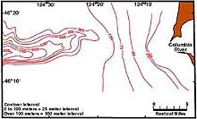
Astoria Canyon indents the continental shelf of the Washington and Oregon coasts only 10 nautical miles west of the mouth of the Columbia River. At the head of the canyon, the water is only about 100 meters deep, deepening to more than 600 m some 10 nautical miles downslope. A narrow feature, the canyon is seldom wider than 5 nautical miles along its shallowest depth contour. The canyon walls are remarkably steep for an underwater feature, approaching 45° in some locations. Currents within the canyon are largely controlled by the direction and magnitude of the currents that flow along the edge of the continental shelf. These "alongshelf currents" typically flow northward in late fall and winter, reversing to southward in spring and summer. Local and distant wind events can complicate or even reverse these tendencies. Interactions between currents and the sea floor produce complicated patterns of nepheloid layers -- horizons of increased loads of suspended particulates -- within and above the canyon. The movements of these particulates are likely to have important consequences for the canyon’s marine life.
Monitoring Oceanographic Conditions
To monitor oceanographic conditions while the expedition is in the field, the team will measure conductivity, temperature, and depth with CTD casts, and optical and chemical sensors will be deployed to measure chemical constituents in the water. The data from these casts will define the distribution of dissolved and particulate materials (e.g., nutrients, methane, organic matter) that can affect the health of organisms living on the canyon floor. To understand how these materials are transported through the canyon, the team will deploy two moorings with sensors to monitor current flow, particulate matter concentrations, and nutrient concentrations. One mooring will be placed at approximately the midpoint of the canyon, against its southern wall. The second will be placed south of the canyon mouth, on the continental shelf. These measurements will be used to assess the oceanographic conditions under which biologically important materials move up or down the canyon.

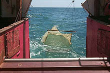
Trawl sampling the mid-water depths of Astoria Canyon will help to refine distribution and abundance estimates of marine life generated by acoustic measurements and video. Click image for larger view.
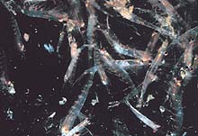
Krill, a tiny invertebrate related to shrimp, is a favorite food of some whales in the mid-water realm. Click image for larger view.
Examining the Sea Life
The midwater biota of the canyon and adjacent oceanic waters will be examined in several ways. Observations will be recorded during the descent and ascent of the ROPOS ROV (remotely operated vehicle) to examine the vertical distribution and behavior of any midwater organisms visible in the videos. These organisms will probably include large jellyfish, crustaceans, fish and squid. Concurrently, the team will conduct acoustic measurements of the backscatter of these organisms using a multi-frequency echosounder. By using three frequencies, the researchers will be able to identify aggregations of plankton and nekton, and observe their distribution in space and time. Finally, aggregations of interest in either the ROV observations or acoustics will be sampled using midwater or bottom trawls.
An Isaacs-Kidd Midwater Trawl will be used at different times of the day to conduct midwater trawling for large zooplankton and micronekton. Larger fishes and invertebrates will be sampled using a commercial midwater trawl deployed from a fishing boat. Samples from these trawls will be used to examine size distribution, diets, and stable isotope composition. The team hopes eventually to determine the importance of food-web linkages between the oceanic and slope/canyon fauna.
Sign up for the Ocean Explorer E-mail Update List.


