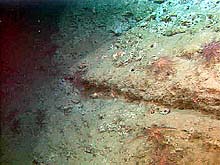
An oblique view of a headwall scarp of a landslide, which has been undercut by eroded material transported down the wall to the base of the slide. Click image for larger view.
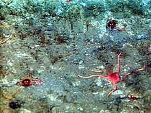
Much of the area is mudstone, which is very porous and easily bored by the organisms that inhabit the canyon. Shrimp, with brightly glowing eyes, are nestled in holes on the scarp wall above a landslide area. The red brittle star in the foreground is an unknown species. Click image for larger view.
Submarine Landslides
July 2, 2001
Jeff Goodrich, Teacher-at-sea
Earth Science Teacher
Lake Oswego High School
Lake Oswego Oregon
and
Susan Merle, Geological Research Assistant
CIMRS Program, Oregon State University
Vents Program, Pacific Marine Environmental Laboratory, NOAA
ROPOS Dive R600, the fifth of the expedition, focused primarily on geology and invertebrate investigations. The geological purpose was to look at the most recent landslide in a larger slide complex. We knew it is the youngest slide, because it cut through other slide features. The treat of this exploration was observing the wall bounding the western side of this young slide. At the top of the wall, we found very porous (lots of holes) claystone with a variety of organisms inhabiting this unique environment. As the lights of the remotely operated vehicle (ROV) ROPOS panned over the wall, the eyes of shrimp inhabiting the holes gleamed back at us like lights on a Christmas tree. The sampled invertebrates included a hermit crab with an anemone growing on its shell, a crinoid, an urchin, a sea pen, and a tiny nudibranch (sea slug).
ROPOS Dive R601, the sixth of the expedition, took place on the southern wall. The first transect headed up a tributary canyon, in hopes of finding what looked like a possible fault trough in the bathymetry/sidescan sonar data. Instead, the substrate was mostly soft sediments, and the elusive fault was not found.
Our focus shifted to invertebrate studies, during which we tempted brittle stars with a bag of shrimp to see if they would dine on it. Oddly enough, they showed only mild interest in the "free" food. Some even headed in the opposite direction. The samples collected included a sun star, a gastropod (snail), a crab, and a rock covered with brittle stars.
Between dives, the scientists took advantage of the ship to study the mid-water realm. Experiments included bioacoustic profile transects across the canyon to observe the vertical migration of fish and krill. The profiler can also be used to identify some fish species and numbers. The mid-water trawl was deployed to accompany the profiler and verify its findings. CTD (conductivity, temperature, depth) casts were also performed to collect numerous water samples at specific water-column depths.
The seventh and final ROPOS dive in Astoria Canyon will begin tonight, Monday, July 2, at 6 pm PST.
Stay tuned.
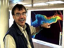
Waldo Wakefield, Co-chief scientist of the Lewis and Clark Legacy Expedition.
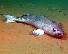
A sablefish rests on the soft sediments blanketing the deep canyon floor at about 800 m. The red spots (top) are lasers, spaced about 10 cm apart, that are used to estimate the size of organisms inhabiting the area. Click image for larger view.
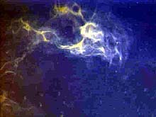
A squid, startled by the presence of ROPOS descending to the sea floor, reacts defensively by squirting ink at the ROV. Click image for larger view.
erview with Dr. Waldo Wakefield
Co-chief Scientist, Astoria Canyon Exploration
Fisheries Ecologist, National Marine Fisheries Service, NOAA
July 2, 2001
Ocean Explorer Team: What was known about Astoria Canyon before this cruise?
Dr. Wakefield: This is one of the larger submarine canyons on the west coast and has not been studied in detail. We have this first glimpse of the canyon in a way that is unprecedented for this part of the coastline. Before, we had very poor maps of the canyon. This exploration has provided the opportunity to develop a high resolution map that allowed us to make these dives. But, it's a huge canyon and making just 7 ROPOS dives doesn't give very broad coverage of what's here. This expedition is just the tip of the iceberg of work in the canyon.
Ocean Explorer Team: What is your specific research interest here at Astoria Canyon?
Dr. Wakefield: My specific interest, besides the overall interdisciplinary part of the project, is to work with the other fish ecologists and ichthyologists on board to look at fish associations with different types of habitats in the canyon. Our group has an ongoing project on Heceta Bank, Oregon. We want to compare the fish assemblages we see associated with habitats of the canyon to assemblages we see
associated to similar and different habitats on Heceta Bank. Our group is trying to develop a better understanding of fish associations with specific habitat types all along the west coast of North America. It's part of an overall growing interest in starting to pay more attention to marine habitats and specifically marine benthic habitats. We have marine geologists, such as Bob Embley, involved to develop ways to look at these habitats in a geologically consistent way. Geologists also understand all of the different tools that are needed to map the seafloor and interpret it.
Ocean Explorer Team: What's the most challenging aspect of co-leading this expedition?
Dr. Wakefield: One of the most challenging aspects occurred before we started the expedition. The coordination of all the logistics of getting the scientists and all their equipment together, integrated, and on the boat was ominous. Just organizing the travel and shipping logistics was an enormous task. During the
expedition I try to coordinate all the different scientific interests and disciplines and equipment. Complicating this is the weather and breakdown of equipment that result in changes. It seems like everything always takes longer than everyone anticipates. Time wise, one might be better off if you just multiply everything by two.
Ocean Explorer Team: What do you hope to get out of the expedition?
Dr. Wakefield: I hope this group of scientists go back to their respected institutions and analyze the different data sets and then have some type of post-expedition science meeting to present our results to each other. This will provide the background for people to write very specific proposals to do more specific projects here to address hypotheses and questions that come out of this work in all the different disciplines.
Sign up for the Ocean Explorer E-mail Update List.


