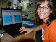
Liz Podowski demonstrates how MatLab works to create photomosaics. Click image for larger view and image credit.
Photomosaics: Worth 1,000 Words (At Least!)
August 30, 2009
Liz Podowski
Research Assistant
Penn State University
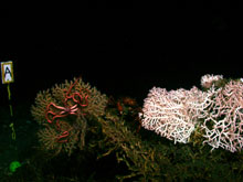
A primary goal of Lophelia II expedition is to understand the animal communities that live in and around deep-sea, cold-water coral reefs in the Gulf of Mexico. Deep-sea coral reefs are bursting with life. Reef-building corals provide hard surfaces on which other animals can settle, and they create complex structures within which prey can seek refuge from predators. But, these reefs are deep — located hundreds of meters below the ocean's surface — and they are difficult to access.
So, how do we study such remote ecosystems?
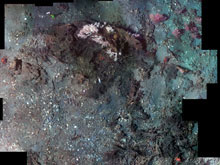
One of our most powerful tools is photography. Yesterday, we completed our first photomosaic of an outcrop of hard coral, Madrepora oculata (see left image below). Photomosaics? You may have made a mosaic before, either by assembling many different colors to form one continuous image or by connecting overlapping pictures to create a landscape view of an area. Well, we essentially do the same thing in the deep sea.
The remotley operated vehicle (ROV) Jason is equipped with a variety of equipment including a high-resolution camera positioned in a down-looking position. One of my jobs out here is to work with the ROV Jason team to identify the area to be photographed (in this case about 25 m2 of Madrepora reef, gorgonians, and clamshell debris) and direct the picture taking process. Surrounded by computer monitors in the control van to see what the ROV sees, we first adjust the vehicle’s lighting and position above the seafloor to ensure our pictures will be the highest quality possible. Then, we begin to mosaic. With superb navigation and incredible stability, the ROV completes nine parallel transects across the delineated area, while I continuously snap overlapping photographs.
Once Jason is back on the research vessel's deck, I download the photos. I spend the rest of the day selecting images, adjusting them in Photoshop, and using specialized computer software to connect and blend the overlapping images. The final product is a seamless high-resolution, landscape image of the seafloor.

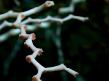
This close up of Madrepora oculata shows its calyx structure. Madrepora is one of the reef-building corals. Click image for larger view and image credit.
There is a great deal you can learn from such a mosaic. For example, we can identify and count the different animals present in the mosaicked area to determine the abundance and diversity of associated fauna (animals) hosted by the Madrepora reef. Furthermore, each of the images we use to construct the mosaic has a unique set of geographic coordinates. This spatial information allows us to analyze the mosaic in a geographic information system (GIS), within which we can calculate areas and densities, and quantitatively study animal associations.
Photomosaicking is great way to initially survey a community; it is a non-destructive technique that lets us identify first-order patterns of animal distributions and biological associations. Of course, even mosaics have limits. Photographic images compress three-dimensional objects into a two-dimensional space. Consequently, we see only the animals living on the surface of hard-corals and other substrata, not those hiding beneath a branch or tucked behind another organism.
One way around this is to make physical collections within the same area of the mosaic. We use devices like our “musselpots,” a quantitative sampler that collects all species in and around a small target area. We can then identify and count the smaller, sometimes microscopic, animals living within the matrix of habitat hard corals create. By pairing our mosaics with physical collections, we can quickly and efficiently learn a great deal about the communities hosted by deep-sea, hard corals. After all, a picture is worth a thousand words.


