


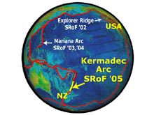
The New Zealand American Submarine Ring of Fire 2005 (NZASRoF'05) expedition will take place on the Kermadec Arc, northeast of New Zealand (indicated by the thick, yellow line). The image shows a global view of the Pacific Ring of Fire. The 3 previous Submarine Ring of Fire expeditions are indicated at Explorer Ridge and the Mariana Arc. The dashed line is the crest of the Mid-Ocean Ridge system and solid lines show plate boundaries defined by island arcs and trenches. Click image for larger view.
The New Zealand American Submarine Ring of Fire 2005 Expedition
Bob Embley
Co-Chief Scientist for the New Zealand American Submarine Ring of Fire Expedition
(Legs 1 and 2)
Geophysicist
NOAA Vents Program, Pacific Marine Environmental Laboratory – Newport,
Oregon
Gary Massoth
Co-Chief Scientist for the New Zealand American Submarine Ring of Fire Expedition
(Leg 1)
Principle Scientist
Institute of Geological and Nuclear Sciences Ltd
Lower Hutt, New Zealand
Alex Malahoff
Co-Chief Scientist for the New Zealand American Submarine Ring of Fire Expedition
(Leg 2)
Chief Scientist, Chief Executive, Institute of Geological and Nuclear Sciences
Ltd
Lower Hutt, New Zealand
The New Zealand American Submarine Ring of Fire 2005 (NZASRoF'05)
expedition on the University of Hawaii research vessel Ka'imikai-o-Kanaloa will
begin April 3 in Pago Pago, American Samoa and end in Tauranga, New Zealand
on May 10. An international team of explorers from New Zealand and the
United States will conduct dives at approximately six volcanoes using the
human-occupied vehicles (submersibles) PISCES IV and V, operated by the
Hawaii Undersea Research Laboratory (HURL). The submersibles will be used
to explore the geology, biology and chemistry of submarine volcanoes along
the largely unexplored Kermadec Arc that extends N-NE of New Zealand's
North Island. These volcanoes and the adjacent Kermadec Ridge lie westward
of the 800 mile-long Kermadec Trench, where the western edge of the vast
Pacific plate descends beneath the Australasian plate to the west. The
volcanoes form as gases and water rising off the down-going plate induce
melting of the surrounding rocks forming magma lenses beneath the volcanoes.
This expedition is the culmination of seafloor mapping and oceanographic
surveys conducted jointly by New Zealand and U.S. scientists over the past
5 years. Two New Zealand Crown Research Institutes (Geological and Nuclear
Sciences, or GNS, and National Institute of Water and Atmospheric Research,
or NIWA), and the NOAA Ocean Exploration Program have joined together to
provide the funding and the scientific expertise to make this expedition
possible. Sixteen scientists representing the disciplines of geology, chemistry
and biology will take part in the explorations.
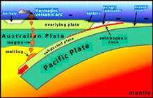
This illustration shows the Pacific plate in the east colliding with the Australian plate in the west. A consequence of this collision is subduction with the down going slab comprised of oceanic crust, or lithosphere, and a thin veneer of pelagic sediment. This causes extension behind the subduction zone, which is represented by backarc basins forming behind the arc front. At certain depths, usually around 200 kilometers (~100 nautical miles), there is melting of the subducted materials. The melting produces magmas that rise buoyantly to pond in the overlying mantle wedge and periodically erupt on Earth's surface as lavas, forming arc volcanoes. Click image for larger view.
Expedition is a Culmination of 5 Years of Preparation
Although most of the target volcanoes will be visited for the first time with
a submersible, we will be relying on maps and other ocean surveys conducted
over the past 5 years by New Zealand and U.S. scientists, many of whom are
taking part in this expedition. Many of these volcanoes were unknown before
new oceanographic and bathymetric surveys were conducted by the GNS ![]() ,
the NIWA
,
the NIWA ![]() ,
and the Pacific Marine Environmental Laboratory
,
and the Pacific Marine Environmental Laboratory ![]() NOAA Vents Program in 1999-2004. Three
joint expeditions have been made on the New Zealand research vessel Tangaroa
since 1999, known as NZAPLUME (New Zealand American PLUme Mapping Expedition) I, II and III
NOAA Vents Program in 1999-2004. Three
joint expeditions have been made on the New Zealand research vessel Tangaroa
since 1999, known as NZAPLUME (New Zealand American PLUme Mapping Expedition) I, II and III ![]() , that focused
on locating the active vent sites by mapping and sampling hydrothermal plumes
associated with active venting.
, that focused
on locating the active vent sites by mapping and sampling hydrothermal plumes
associated with active venting.
Deciding on the Dive Sites
How active are these submarine volcanoes? Several of the
volcanoes have had historic activity detected by hydrophones and/or direct
observations from ships or planes (e.g., Monowai, Rumble V) over the past
30 years. For most, however, the potential for activity is uncertain because
submarine eruptions are difficult to monitor. However, one measure of a
volcano's potential for eruption is the presence or absence of an underlying
heat source. Heat sources beneath volcanoes above sea level usually give
rise to hot springs and fumaroles on the surface. This is also the case
for submarine volcanoes. A seafloor hot spring can actually be much “hotter'
than one at sea level because of the higher pressures. Water boils at
almost 250° C (~480°F) at only 350 meters (1165 ft.) depth. These
seafloor hot springs can produce buoyant plumes of chemically anomalous
water that are detectable with conventional oceanographic equipment and
techniques. Hundreds of such measurements with a CTD made
along the Kermadec and Tonga submarine volcanoes in the past 5 years
have detected more than 30 hot spring sites. Because some of these sites
are shallower than 100 meters (328 ft.) they reside within the photic
zone. These zones are very unusual because they represent a coincidence
of photosynthetic and chemosynthetic organisms. The implication of this
is not presently known - It is a new area of research.
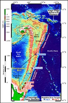
Southwest Pacific from Samoa (northeast) to New Zealand (southwest). Possible dive targets for Leg 1 and Leg 2 of the NZASRoF'05 expedition are indicated. Leg 1 sites are indicated by blue circles and blue text. Leg 2 sites are indicated by red circles and red text. Leg 1 starts in Pago Pago, ending in Tauranga. Leg 2 departs and returns from Tauranga. Bathymetry data are: satellite-derived (bottom, 3500 meter resolution); EM300 (top, along the arc, 25 meter resolution). Satellite-derived bathymetry from Sandwell and Smith. EM300 bathymetry data are courtesy of New Zealand National Institute of Water and Atmospheric Research. Click image for larger view.
Two Parts of the Expedition (Legs1 and 2)
The New Zealand American Submarine Ring of Fire Expedition will be divided
into two parts. The first “Leg” will depart from Pago Pago, American
Samoa on April 3 and arrive in Tauranga, New Zealand on April 22. After departing
Pago Pago and transiting for several days the RV Ka'imikai-o-Kanaloa will
arrive at Monowai Volcano. For each volcano visited, the first dive(s) will
attempt to locate the source of the most active hydrothermal signals measured
on prior cruises. After the sites are located, the dives will concentrate on
sampling and more detailed observations, as well as mapping of the sites. Some
volcanoes have more than one active site, requiring additional dives. The remotely
operated vehicle (RCV-150) will be used in the evening hours after the
PISCES returns onboard to locate and map other potential dive sites for the
PISCES. In addition, the GNS MINTS plume profiling system ![]() will be onboard for site reconnaissance. Dives
are also planned at two other sites, Macaulay and “W” volcanoes during
the first leg. After changing some personnel in Tauranga, the second leg of
the expedition will conduct dives on several more volcanoes near New Zealand.
In addition, 7 moored instrument packages deployed at Brothers Volcano during
a joint cruise on the Tangaroa in September, 2004 will be recovered.. These
instruments are part of a novel Fluid Flux Experiment designed to assess the
amounts of fluids and gases going into the ocean from a submarine volcano.
will be onboard for site reconnaissance. Dives
are also planned at two other sites, Macaulay and “W” volcanoes during
the first leg. After changing some personnel in Tauranga, the second leg of
the expedition will conduct dives on several more volcanoes near New Zealand.
In addition, 7 moored instrument packages deployed at Brothers Volcano during
a joint cruise on the Tangaroa in September, 2004 will be recovered.. These
instruments are part of a novel Fluid Flux Experiment designed to assess the
amounts of fluids and gases going into the ocean from a submarine volcano.
The scientists involved in this expedition are very excited to be part of one of the first submersible expeditions to these Kermadec submarine volcanoes.