NOAA Ship Okeanos Explorer: Beyond the Blue: Illuminating the Pacific (EX2402-EX2406, EX2501-EX2508)
May 2024 - November 2024; April 2025 - October 2025
Beyond the Blue: Illuminating the Pacific is a multifaceted science campaign designed to raise collective knowledge, understanding, and appreciation of waters in the Pacific Islands region through coordinated mapping and exploration expeditions, data management and sharing, strategic partnerships, and outreach and engagement. In 2024, NOAA Ocean Exploration began work with partners to conduct multiple expeditions on NOAA Ship Okeanos Explorer, lead outreach and education activities and events, and build additional partnerships in the Pacific Islands region in support of Beyond the Blue.
Expedition dates, numbers, names, and ports of call for the six telepresence-enabled expeditions being conducted on Okeanos Explorer in support of Beyond the Blue in 2024-2025 are as follows:
May 14 - June 9, 2024: EX2402: Beyond the Blue: Hawai‘i Mapping / Honolulu, Hawai‘i - Honolulu, Hawai‘i
June 21 - July 9, 2024: EX2403: Beyond the Blue: Papahānaumokuākea Mapping 1 / Honolulu, Hawai‘i - Honolulu, Hawai‘i
July 18 - August 12, 2024: EX2404: Beyond the Blue: Papahānaumokuākea Mapping 2 / Honolulu, Hawai‘i - Honolulu, Hawai‘i
August 20 - September 7, 2024: EX2405: Beyond the Blue: Johnston Atoll Mapping 1 / Honolulu, Hawai‘i - Hilo, Hawai‘i
September 14 - October 10, 2024: EX2406: Beyond the Blue: Johnston Atoll Mapping 2 / Hilo, Hawai‘i - Honolulu, Hawai‘i
October 19 - November 12, 2024: EX2501: Beyond the Blue: Papahānaumokuākea Mapping 3 / Honolulu, Hawai‘i - Honolulu, Hawai‘i
June 20 - July 16, 2025: EX2504: Beyond the Blue: Transit Mapping / Honolulu, Hawai‘i - Koror, Palau
July 22 - August 11, 2025: EX2505: Beyond the Blue: Palau Mapping 1 / Koror, Palau - Koror, Palau
August 18 - September 11, 2025: EX2506: Beyond the Blue: Palau Mapping 2 / Koror, Palau - Guam
September 19 - October 8, 2025: EX2507: Beyond the Blue: Palau Mapping 3 / Guam - Koror, Palau
2025 Expeditions Overview
In 2025, NOAA Ocean Exploration will lead a total of seven telepresence-enabled expeditions on Okeanos Explorer to collect critical mapping data in deep waters of Hawaiʻi, Palau, and Guam in support of Beyond the Blue. These expeditions include:
- March 17 - 27, 2025: EX2502: Beyond the Blue: 2025 ROV and Mapping Shakedown / Honolulu, Hawai‘i - Honolulu, Hawai‘i
- April 8 - May 5, 2025: EX2503: Beyond the Blue: Papahānaumokuākea ROV and Mapping / Honolulu, Hawai‘i - Honolulu, Hawai‘i
- June 20 - July 16, 2025: EX2504: Beyond the Blue: Transit Mapping / Honolulu, Hawai‘i - Koror, Palau
- July 22 - August 11, 2025: EX2505: Beyond the Blue: Palau Mapping 1 / Koror, Palau - Koror, Palau
- August 18 - September 11, 2025: EX2506: Beyond the Blue: Palau Mapping 2 / Koror, Palau - Guam
- September 19 - October 8, 2025: EX2507: Beyond the Blue: Palau Mapping 3 / Guam - Koror, Palau
2024 Expeditions Summary
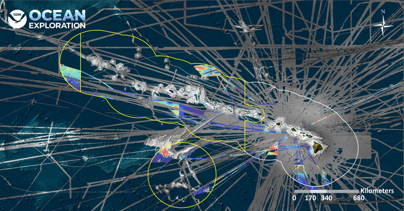
In 2024, NOAA Ocean Exploration conducted a total of six Beyond the Blue expeditions on Okeanos Explorer. As this year marked the return of Okeanos Explorer to the central Pacific region following work on the ship in the region in 2015-2017, efforts in 2024 focused on mapping deep waters of Hawaiʻi and Johnston Atoll. The mapping focus allowed us to build a foundation for future work through the collection of data needed for further exploration and provide a baseline of data needed to manage regional marine protected areas, including Papahānaumokuākea Marine National Monument and the Pacific Remote Islands Marine National Monument, now known as Pacific Islands Heritage Marine National Monument. We also built upon and established the collaboration, partnerships, and support necessary for successful exploration work in the region in future years, particularly in light of Beyond the Blue campaign efforts.
In total, during the the six expeditions on Okeanos Explorer in 2024, NOAA Ocean Exploration used multibeam sonar to map approximately 251,901 square kilometers (97,260 square miles) of seafloor deeper than 200 meters within the U.S. Exclusive Economic Zone (EEZ). This includes 136,685 square kilometers (52,774 square miles) of the Papahānaumokuākea Marine National Monument, 43,840 square kilometers (16,927 square miles) of Johnston Atoll within the Pacific Islands Heritage Marine National Monument, and 71,376 square kilometers (27,558 square miles) of the Hawaiian EEZ outside of marine national monuments. The three expeditions within Papahānaumokuākea increased the monument’s modern mapping coverage by approximately 9%. The two expeditions to Johnston Atoll mapped approximately 10% of the Johnston unit of the Pacific Islands Heritage Marine National Monument.

For specific summaries from the different expeditions conducted on Okeanos Explorer in support of Beyond the Blue in 2024, visit the expedition links below:
- May 14 - June 9, 2024: EX2402: Beyond the Blue: Hawai‘i Mapping / Honolulu, Hawai‘i - Honolulu, Hawai‘i
- June 21 - July 9, 2024: EX2403: Beyond the Blue: Papahānaumokuākea Mapping 1 / Honolulu, Hawai‘i - Honolulu, Hawai‘i
- July 18 - August 12, 2024: EX2404: Beyond the Blue: Papahānaumokuākea Mapping 2 / Honolulu, Hawai‘i - Honolulu, Hawai‘i
- August 20 - September 7, 2024: EX2405: Beyond the Blue: Johnston Atoll Mapping 1 / Honolulu, Hawai‘i - Hilo, Hawai‘i
- September 14 - October 10, 2024: EX2406: Beyond the Blue: Johnston Atoll Mapping 2 / Hilo, Hawai‘i - Honolulu, Hawai‘i
- October 19 - November 12, 2024: EX2501: Beyond the Blue: Papahānaumokuākea Mapping 3 / Honolulu, Hawai‘i - Honolulu, Hawai‘i
Education Themes
Media Resources
Media Contacts
Emily Crum
Communications Specialist
NOAA Ocean Exploration
ocean-explore-comms@noaa.gov
Keeley Belva
Public Affairs Officer
NOAA Office of Marine and Aviation Operations
keeley.belva@noaa.gov
Sarah Marquis
West Coast/Pacific Islands Media Coordinator
NOAA Office of National Marine Sanctuaries
sarah.marquis@noaa.gov
Expeditions conducted by NOAA Ocean Exploration as part of Beyond the Blue will contribute to the National Strategy for Exploring, Mapping, and Characterizing the United States Exclusive Economic Zone and Seabed 2030.
As appropriate, data collected during all expeditions will be available in NOAA’s public data archives within 90-120 days of its completion and will be accessible via the NOAA Ocean Exploration Data Atlas.


