Beyond the Blue: Papahānaumokuākea ROV and Mapping
(EX2503)
Dates
April 8-May 5, 2025
Vessel
NOAA Ship Okeanos Explorer
Location
U.S. deep waters within the Pacific Islands region
Primary Goal
Map, explore, and characterize ecologically and economically important unexplored deepwater regions of Papahānaumokuākea
Primary Technology
Multibeam sonar, remotely operated vehicles Deep Discoverer and Seirios
Livestream and Updates
Live Video
Dive Plan
April 17, 2025: Solide Seamount
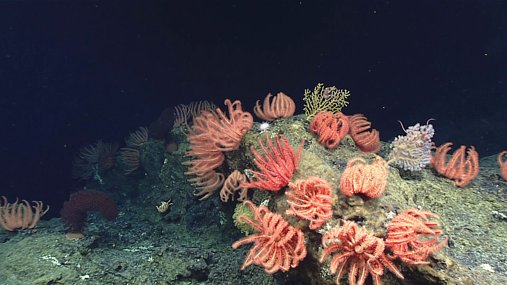
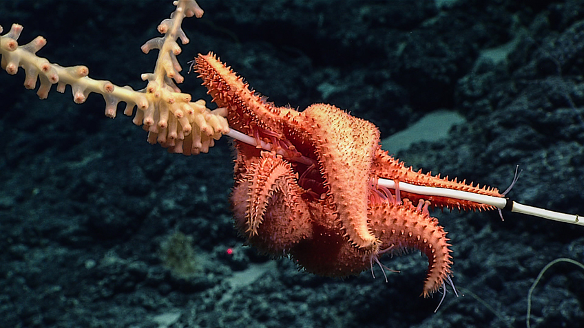
Today’s dive will take place on a southwestern ridge on Solide Seamount. The ridge borders a steep wall that likely formed by slumping of the guyot’s cap carbonates. The goal of this dive is to investigate the biological and habitat diversity of ridge arms below the guyot summit and characterize the habitat transitions along this feature while moving from a starting depth of 1,280 meters (4,200 feet) towards the guyot’s summit, at a depth of approximately 1,100 meters (3,610 feet). Throughout the dive, we will document corals, sponges, fish, and other marine life and keep an eye out for ecological associates of key habitat builders. We will also collect geological samples, including sediments, and environmental DNA (eDNA) water samples to characterize the geology and ecology of the seamount.
Approximate ROV launch: 8:30 a.m. HST / 2:30 p.m. EDT
Approximate bottom arrival time: 9:10 a.m. HST / 3:10 p.m. EDT
Approximate bottom departure time: 3:40 p.m. HST / 9:40 p.m. EDT
Note that this is a tentative plan and is subject to change before or during the dive.
Expedition Overview
From April 8-May 5, NOAA Ocean Exploration will lead a 28-day remotely operated vehicle (ROV) and mapping expedition on NOAA Ship Okeanos Explorer to explore deep waters in and around Papahānaumokuākea. This expedition will include daytime ROV dives to explore the seafloor and water column, overnight mapping operations, and continuous shore-side participation via telepresence technology.
The waters in the Pacific Islands region span a diverse range of ecosystems and dynamic geological environments. They contain some of the last relatively pristine marine ecosystems on the planet and harbor numerous protected species, wondrous geological formations, and undiscovered shipwrecks.
Papahānaumokuākea is a place of extraordinary beauty, known by a single name that commemorates the union of two Hawaiian ancestors – Papahānaumoku and Wākea – who gave rise to the Hawaiian Archipelago, the taro plant, and the Hawaiian people.
In 2024, NOAA Ocean Exploration conducted three expeditions on Okeanos Explorer within Papahānaumokuākea, mapping 36,685 square kilometers (52,774 square miles), thereby increasing the region’s modern mapping coverage by approximately 9%. The collected mapping data will help increase understanding of marine life and habitats to inform management decisions, help to establish a baseline assessment of the ocean environment, and increase public awareness of ocean issues. These data will also be instrumental in informing future exploration efforts, including those being conducted during the Beyond the Blue: Papahānaumokuākea ROV and Mapping expedition.
Expedition Operations
During the Beyond the Blue: Papahānaumokuākea ROV and Mapping expedition, the team will work to further fill gaps in our understanding of the region by conducting focused mapping and ROV operations, with a focus on waters deeper than 200 meters (656 feet) within the region.

Mapping operations will build off of work conducted in 2024 and serve as the basis for planning and executing ROV dives during the expedition. Given the sparsity of mapping data in the region, in some instances, the team will follow a “map and dive” approach, collecting mapping data the night before a dive to guide the path of the ROV on a dive taking place the following morning.
Over the course of the expedition, we will conduct ROV dives to explore deep-sea coral and sponge habitats, seamounts, maritime heritage sites, and the water column. Thanks to telepresence technology, anyone with an internet connection is invited to watch and listen as members of the science community actively engage and guide each dive.
All things permitting, when the ship is not in transit, dives will be streamed most days, April 11 to May 2, from approximately 7 a.m. to 5 p.m. HDT / 1 p.m. to 11 p.m. EDT. Note that dates and times are subject to change.
All data collected during the expedition will contribute to Beyond the Blue: Illuminating the Pacific, a multifaceted science campaign designed to increase knowledge about deep ocean waters in the Pacific Islands region. The campaign directly supports National Strategy for Ocean Mapping, Exploration, and Characterization (NOMEC) goals to close gaps in understanding of a region critical to U.S. national security, fisheries, mineral and energy resources, and biodiversity.
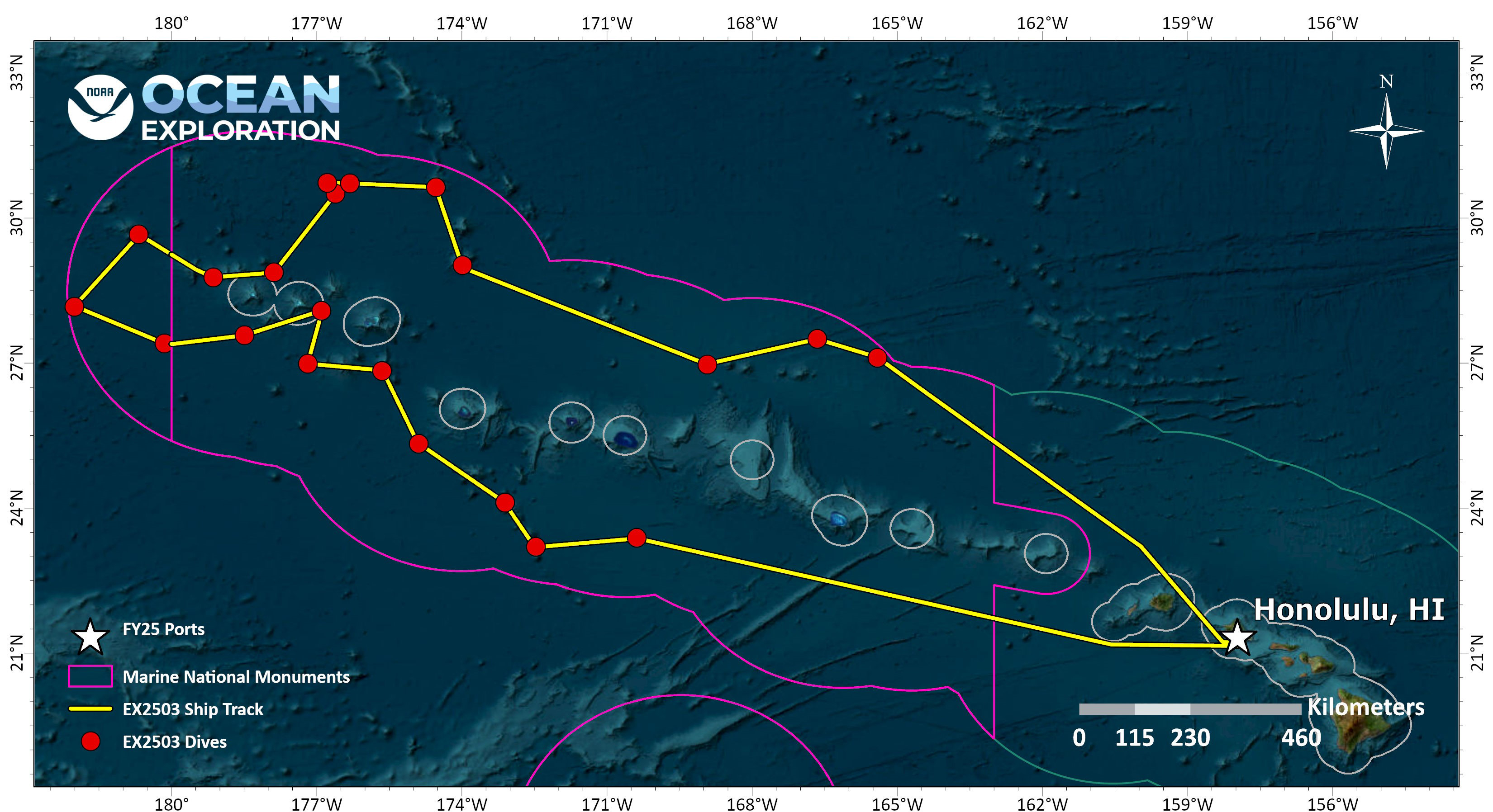
Live Track/Current Position Map
Map data courtesy of NOAA's National Centers for Environmental Information (NCEI).
Dives
Beyond the Blue: Papahānaumokuākea ROV and Mapping includes both mapping and remotely operated vehicle (ROV) operations, with video from ROV dives streamed online in real time while the expedition is underway.
The list below provides information about dives that took place during the expedition. Click on a dive name to find its location on the map and access a link to related image and video highlights. Links to final dive data and summaries will be added when available, after the expedition.
Meet the Explorers
Naming every participant in a telepresence-enabled expedition is next to impossible, as scientists from around the world have provided input into the expedition plan and are expected to participate in dives from shore. However, we've assembled information about the members of the team who are regularly contributing throughout the expedition, either from the ship or on shore – meet the team!

Sara Kahanamoku-Meyer
Expedition Science Co-Lead
University of Hawaiʻi at Mānoa

Brian Kennedy
Expedition Science Co-Lead
Ocean Discovery League

Sam Cuellar
Expedition Coordinator
NOAA Ocean Exploration
Neah Baechler
Mapping Watch Lead
NOAA Ocean Exploration

Jason Meyer
Mapping Watch Lead
University Corporation for Atmospheric Research

Chris Ritter
Remotely Operated Vehicle Team Lead
Global Foundation for Ocean Exploration
Education Content
Education theme pages provide the best of what the NOAA Ocean Exploration website has to offer to support educators in the classroom during this expedition. Each theme page includes expedition features, lessons, multimedia, career information, and associated past expeditions.
From the NOAA Office of National Marine Sanctuaries: Deep-Sea Coral


Related Links
Expeditions
Technology
Media Contacts
Emily Crum
Communications Specialist
NOAA Ocean Exploration
ocean-explore-comms@noaa.gov
Keeley Belva
Public Affairs Officer
NOAA Office of Marine and Aviation Operations
keeley.belva@noaa.gov
Jennifer Crawford
Pacific Islands Region Communications Coordinator
NOAA Office of National Marine Sanctuaries
jennifer.crawford@noaa.gov
For more information, visit the Media Resources page.
Expeditions conducted by NOAA Ocean Exploration as part of Beyond the Blue will contribute to the National Strategy for Exploring, Mapping, and Characterizing the United States Exclusive Economic Zone and Seabed 2030.
Data collected during all expeditions will be available in NOAA’s public data archives within 90-120 days of its completion and will be accessible via the NOAA Ocean Exploration Data Atlas.
Published April 7, 2025
Updated April 14, 2025