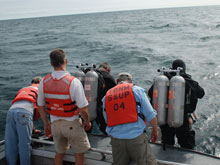
Divers Joe Hoyt and Russ Green prepare to dive the Middle Island Sinkhole assisted by Scott Kendall, Steve Nold and Tom Joyce. Click image for larger view and image credit.
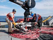
Andrew Yagiela and Jody Breen maneuver the Phantom ROV on the deck of the Laurentian preparing for operations. Click image for larger view and image credit.
A Thunder of Thanks
Sept 12, 2008
Steve Ruberg
Thunder Bay Sinkholes Principle Investigator
NOAA/GLERL
The success of the Lake Huron Sinkhole expedition has depended on the contribution made by many people from a number of organizations including private individuals. Data collection has involved the preparation of time-series instrumentation deployed for periods up to ten months. John Lane, Ron Muzzi and Steve Constant in the Marine Instrumentation Lab at NOAA/GLERL have designed and assembled these time series data acquisition moorings and assisted in deployment of these systems. NOAA/GLERL data management is being led by Anne Clites in collaboration with OE data manager Susan Gottfried of the NOAA National Coastal Data Development Center. Susan has done a thorough job of preparing metadata for project archiving onboard the Laurentian during expedition cruises.
Mission preparation of the Phantom S2 remotely operated vehicle (ROV) for sinkhole operations was done by Kevin Joy and Devin Bonnie at the National Underwater Research Center at the University of Connecticut. The ROV, piloted by Devin Bonnie, has been the primary method used to obtain groundwater samples and physical/chemical mapping data from the deeper Isolated Sinkhole. Sample collection from offshore sinkholes was achieved using research vessels Laurentian and the Huron Explorer. Ship crew members Andrew Yagiela, Jack Workman, Jody Breen, Steve Bawks, Mike Taetsch, and Tom Joyce and marine superintendent Dennis Donahue supported the project with their nautical expertise.
Divers have been crucial in collecting cores, mats, water samples, deploying instrumentation, providing imagery, making maps, and providing the human “feel” for what will succeed in our endeavors and what will not. Project diving was led by Russ Green and supported by Wayne Lusardi, Tane Casserly, Joe Hoyt, and Cathy Green.
Data collection at the El Cajon system has required access to private and State Forest lands. Bill Riggs private pontoon boat located on El Cajon Bay has been the primary “research vessel” for this system, supporting our present Ocean Exploration expedition and previous National Science Foundation funded work. Access to the Michigan Department of Natural Resources (MDNR) managed property along the north shore provided by MDNR Forest Technician Bob Theiner has supported educational opportunities for local schools and diving expeditions to the Blue Hole. Help from MDNR Forest Officers Mark Hanson and Jennifer Nemeth in tracing the chain of sinkholes on land has proved valuable in understanding groundwater inputs to the offshore systems and visualizing sinkhole features. Local expert Joe Sobczek provided additional guidance in regard to on land and nearshore sinkhole insights. Emily McDonald's thorough documentation of the cruise for the public through the OE Signature project website has been a vital part of the project. Thanks to Cathy Darnell for contributing some incredible images of our research site.
The staff at the Thunder Bay National Marine Sanctuary provided office space and sleeping quarters - we couldn't have pulled the project off without help from Joe Geroux, Jean Prevo, and Tera Panknin.
Sign up for the Ocean Explorer E-mail Update List.


