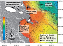
This map shows submerged sinkholes in the Thunder Bay National Marine Sanctuary (TBNMS), Lake Huron. Included are the expedition study sites: Misery Bay, containing the El Cajon Bay Blue Hole; Middle Island Sinkhole; and Isolated Sinkhole. Click image for larger view and image credit.
Thunder Bay Sinkholes 2008
September 2 – 12, 2008
From July 2008 to July 2009, the Thunder Bay Sinkholes project team will explore shallow and deep coastal sinkholes in order to understand the chemical and physical properties that contribute to the unique ecology found in these systems. This multi-investigator team will gather data on the hydrology (the flow rates and dispersion of groundwater), biology, and chemistry from submerged groundwater vents located within the boundaries of the Thunder Bay National Marine Sanctuary, in northwestern Lake Huron.
During the project, the team will collect benthic (bottom) samples of the unusual microbial mats growing in very low oxygen conditions to determine how groundwater chemistry allows them to thrive. Samples of these microbial mats will also be analyzed for their potential application as pharmaceuticals. A long-term understanding of the groundwater's chemical and physical characteristics, such as conductivity (an indication of the presence of ions), temperature, and flow, will be obtained from a moored hydrographic instrument array. Mapping of chemical and biological characteristics over large spatial areas will done using underwater remotely operated vehicles (ROVs) and diver-led sample collection work.
Updates & Logs
Click images or links below for detailed mission logs and updates.
 Mission Summary Principle Investigator Steve Ruberg provides a summary for the Thunder Bay Sinkholes exploration. Scientists obtained sensor measurements and collected samples at nearshore El Cajon, the Middle Island Sinkhole system, and the offshore Isolated Sinkhole system.
 September 12 The success of the Lake Huron expedition depends on contributions made by many people from a number of organizations, as well as private individuals.
 September 11 Each year, hundreds of recreational divers come to Thunder Bay National Marine Sanctuary and brave the chilly waters of Lake Huron for a chance to glimpse sunken history.
 September 10 Since the chemistry of vent water is quite different from lake water, sensors are used to measure its properties.
  September 9 The data manager is responsible for managing the metadata and the data collected, recorded, generated, or otherwise produced from the Thunder Bay expedition. Learn more about his important job.
 September 8 With more than six quadrillion gallons of freshwater, the Great Lakes are "inland seas" worthy of exploration.
 September 7 Sampling and analytical methods are being used to determine the age of the sinkhole waters collected and to identify the sources of these waters.
 September 6 It's important to study sedimentation in the Great Lakes, a source of drinking water for almost 30 million people.
 September 5 Using joysticks, camera controls, and a video monitor, pilots "fly" the Phantom S2 remotely operated vehicle into the Isolated Sinkhole.
  September 4 Scientists use a stereomicroscope to examine purple microbial mats collected during yesterday's dive.
 September 3 The team conducts the first dive studies in the Middle Island Sinkhole.


