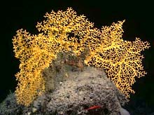
Enallopsammia coral from Lyman Seamount. Click image for larger view and image credit.
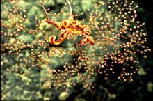
A brittle star (Ophiocreas) wraps its arms around the branches of a Metallogorgia coral. Note the eight extended tentacles on each polyp on the right side of the colony. The name 'Octocorallia' is derived from the eight tentacles.
![]() Click image to view a slide show.
Click image to view a slide show.
Lyman Seamount
August 18, 2005
Les Watling
University of Maine
Allen Gontz
University of Massachusetts
![]() See video of the North Atlantic Stepping Stones Biogeography of Fauna. (Quicktime, 1.9 Mb.)
See video of the North Atlantic Stepping Stones Biogeography of Fauna. (Quicktime, 1.9 Mb.)
We have now completed all three dives at our first dive site, East Corner Rise Seamount, now named Lyman seamount (see below). As we continue to cruise on the Milne-Edwards and Verrill Seamounts, we look back on our experience at Lyman.
Lyman Seamount was different than any of the seamounts we have visited in the past along the nearby New England Seamount Chain. The seamount consists of one major peak and a series of ridges running from the peak to the west and north. Currents were generally sluggish over the whole of the seamount except at the topmost ridge. As a result there was a build-up of biogenic sand over all but the steepest slopes. While there were some very interesting sand-inhabiting and rock-dwelling invertebrates on Lyman Seamount, coral densities were low. On the other hand, Lyman Seamount produced several corals, both octocorals and black corals, that were either new records or were new to science. The same can be said of the fishes. With the exception of one group of about 6 oreos, fish were rare but represented several species that we had not previously seen.

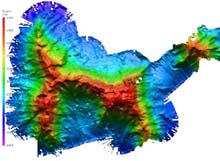
Bathymetry of the Lyman Seamount, shaded relief map. The image above shows the entire East Corner Rise seamount complex, tentatively named Lyman Seamount. The resolution of the image is approximately 40 m. The map was created with data from 25 hours of surveying over three days. Click image for larger view and image credit.
One of the major goals of this cruise is to survey the dive sights to get a better picture of their topography. The Ron Brown is equipped with a SeaBeam 2120 multibeam bathymetric system. This system uses 151 beams in a 150 degree fan-shaped array to map the topography of the seafloor. The image to the left shows the entire Lyman Seamount complex. The resolution of the image is approximately 40 m. The map was created with data from 25 hours of surveying over three days. Our survey observed a complex feature with two major peaks and one minor peak connected by long, narrow ridges. The complex rises from the abyssal plain to within 1100 m of the sea surface. Shaded relief imagery is generated by simulating illumination from the sun at a given azimuth (the direction from which the sunlight is coming) and elevation. This type of imagery tends to highlight features facing the illumination and shading those facing away. The azimuth for this image was 345 degrees with an elevation of 60 degrees.

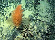
Top view of a stalked crinoid next to the bamboo coral (Acanella). The crinoid mouth faces up and is surrounded by 10 feathered arms. Click image for larger view and image credit.
Another goal of the science party is to name the unnamed seamounts being explored during this expedition. The process involves submitting an application to the International Hydrographic Organization and the Intergovernmental Oceanographic Commission. The naming convention we have selected is to name them after well-known early taxonomists whose works we are using to identify the fauna of the region. Eastern Corner Rise has been named Lyman Seamount after Theodore Lyman, major benefactor at Harvard University who started the Museum of Comparative Zoology, and was himself a brittle star taxonomist. Lyman described several hundred species of brittle star and urchin-like echinoderms.
Sign up for the Ocean Explorer E-mail Update List.


