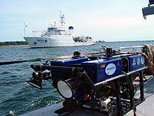
The NOAA Ship Thomas Jefferson sought safe harbor in Gloucester from the deteriorating sea conditions brought on by Hurricane Isabel. Photo: Anne Smrcina, SBNMS. Click image for larger view.
The Portland Mission Concludes
Sept. 19, 2003
Anne Smrcina
Education and Outreach Coordinator
Stellwagen Bank National Marine Sanctuary, NOAA
The Steamship Portland Mission concluded yesterday afternoon, two days short of the planned cruise schedule, but successful nonetheless. After months of planning, long days building specialized technology, and the costs inherent in acquiring an appropriate ship and crew, the loss of two days is disappointing. Nevertheless, the science party and ship’s crew were positive about the results.
Weather is one of those variables over which we have no control. Most of the time September in New England is mild, but it's still hurricane season, and Isabel decided to pay a visit. Although the storm hit well to the south of us, the effects of a hurricane travel long distances in the ocean, and large swells make ocean research very difficult and dangerous, if not impossible. Ours wasn’t the only research vessel to seek safe harbor -- we were in fine company in Gloucester with the newest NOAA ship, the Thomas Jefferson, and the research vessel Seward Johnson.
The science team listed a number of accomplishments from our six days at sea, including the use of new georeferenced tracking software to pilot the ROV (remotely operated vehicle) around four wreck sites; imaging of all the sites with a high-definition camera that yielded detailed pictures of these historical resources in the sanctuary; and the development of educational materials about submerged cultural resources.
We’re using this last day in Gloucester to pull together some content and images for the Web. Our Web Coordinator Caritta Lee, from NOAA’s National Ocean Service Communications and Education Division, has manned the fort on shore, serving as a link between the sea-bound team and headquarters in Silver Spring, MD. David Hall from the National Marine Sanctuary Program, also in Silver Spring, succeeded in getting our message out to the media. You may have seen our mission covered on one of the region’s TV stations, heard about us on the radio, or read articles prepared by the Associated Press, the Boston Herald, the Boston Globe and the Hartford Courant.
We also look forward to the television special due to air early next year on the Science Channel of the Discovery Network. The amazing high-definition images acquired during the mission were made possibly by the channel’s interest in the story of the steamship Portland and the producers' ability to acquire this advanced underwater imaging equipment. Just as a research cruise takes many months to plan and execute, so does a television show. Read on to get an insider’s view of this aspect of the Steamship Portland Mission.

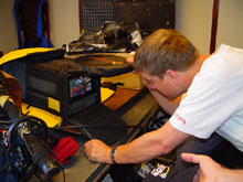
The high-definition camera produces a wider and more detailed image than traditional cameras. Jeff checks the quality of a shot in the playback unit. Photo: Anne Smrcina, SBNMS. Click image for larger view.
Making The Documentary
David Conover
Author, Wreck of the Portland
Many a person has surely wondered what could be seen if the sea retreated, revealing a sea floor with all the tragedies, lost items, snagged nets, and discarded stuff of yesteryear. What lessons would evidence of these past struggles reveal? Thanks to the development of some very cool ocean imaging equipment, such as sidescan sonar, the remotely operated vehicle (ROV) and multibeam imaging of the ocean floor, people around the world are now discovering missing clues to unsolved historical mysteries of the deep. How does all this fancy new imaging stuff work? What can we learn when we use it?
These were the questions producer David Clark wanted to explore in an episode of the Science Channel series "Science of the Deep." When he heard about the wreck of the Steamship Portland and the ongoing investigative work being done in the Stellwagen Bank National Marine Sanctuary, he sought and received a green light from the Science Channel to begin production.
To make the most of the imaging opportunities, High Definition (HD) was his format of choice, and the pre-production researchers got to work. Based on their findings, a list of potential sequences was put together depicting the initial search and discovery of the Portland. These included interviews with Arnie Carr and John Fish on their use of sidescan sonar, and an interview with physical oceanographer Dick Limeburner as he explained how his understanding of four types of currents helped him predict where the ship might be located.
To help visualize the historical backstory, evocative historical visualizations were created: a surfman looking for debris of a vessel lost at sea, storm waves, lighthouses sending out their hopeful beacons, and snow blowing in the night. Where original production could not achieve the desired results, a stock footage researcher sought footage from stock libraries. Computer generated images (CGI) were designed to visually convey the movements of the vessel in its final, fatal struggle.

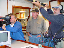
The shipboard crew from the Science Channel (part of the Discovery Network): Jeff Streich, cameraman; David Clark, producer; and Ray Day, sound recordist. Photo: Anne Smrcina, SBNMS.Click image for larger view.
Lastly, plans were made to document the current expedition. Cameraman Jeff Streich and sound recordist Ray Day joined David Clark on board the R/V Connecticut. To help scientists and archaeologists explain their hopes and goals, the documentary team also took a few other tools to sea, including a scale wooden model of the Portland, charts, ship’s lines, and sidescan sonar printouts. The National Undersea Research Center team prepared an ROV and added an HD camera from the Woods Hole Oceanographic Institution and special 200-watt lights that mimic the sun.
When all is said and done, several dozen people will have contributed to the production effort, leading to 15 to 20 hrs of footage. An editor and writer then join the team, as do a composer and a narrator. Writing, editing, design, and composition all merge in a creative swirl that lasts 6 to 8 wks., and the 1-hr film is complete (actually 46 min, accounting for commercials).
The Science Channel plans to broadcast the result in a special event time slot, sometime in the first quarter of 2004. Stay tuned.


