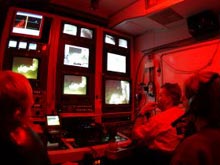
Sonsub pilot Maurice Rivard (far right), flying the Innovator ROV during surveys at Viosca Knoll, with Sonsub technician Keith Hyatt (far left) observing, and scientist Sandra Brooke (in headphones) providing guidance. The red light in the ROV control room, also known as the "van," provides illumination for those working inside the van without obstructing the images from the video monitors during dives. Click image for larger view.
A Lone Lophelia at Viosca Knoll
September 23, 2003
Sandra Brooke
University of Oregon
Julie Olson
University of Alabama
We arrived at our first ROV (remotely operated vehicle) dive site at Viosca Knoll at 7:30 this morning after an unscheduled detour to Venice, LA, to mend a broken generator. The ROV was in the water by 8:27 am and it submerged through the aqua blue of summer Gulf surface water, through the deep gray-blue at the base of the photic zone, and into the dark ocean depths. At 1,138 ft, the ROV lights illuminated the benthos as we descended upon it. We were hoping to see the tangled bright white colonies of the deep-water coral Lophelia pertusa, a framework-building stony coral with an intricate structure that supports diverse communities of associated fauna. Alas, we found mud . . . lots of it! Actually, mud is not as dull as it might seem; if you look closely, you will see entrances to the tunnels that are homes for various burrowing creatures. There are also track marks from scavengers such as crabs or the giant isopod, Bathynomus, which search the sea floor for food, or the trails of sea cucumbers that consume sediment and harvest the organic material as they meander along in the dark.
Mud is indeed a very useful substance, but not the focus of today’s ROV dives, so we continued along a series of 200-m east-west transects, in search of harder substrate. After a while we started to stumble upon several different species of anemones. Some formed unusual, bush-like mounds, and others were isolated from each other, but formed large, lovely, continuous white fields.
As we continued to progress up the slope, occasional gorgonians and glass sponges were seen, along with various fish. The composition of the ocean floor also began to change and many small carbonate boulders were noted. As more solid substrate for attachment became available, the amount and diversity of life forms also began to increase, providing some amazing images. Although we recorded some interesting footage and viewed some spectacular organisms, we did not discover any hard corals during our transects, which was our goal, and so the dive was ended in order to prepare for the next.
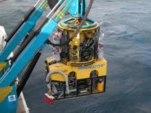
The tether management system sits on top of the ROV during deployment and recovery of the sub, and is suspended by the support vessel above the ocean floor during dives. It manages the tether line for the ROV as it moves down to the ocean floor, ensuring that it doesn’t drag along the bottom, and is secondarily used for sample storage, as can be seen from the various baskets hanging from the frame. Click image for larger view.
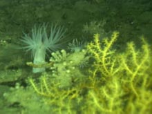
For the second dive, the ROV was launched northeast of our first dive site. As we again descended through the myriad shades of blue to black, we eagerly anticipated finding great swaths of Lophelia corals. The ocean floor greeted us at 1,208 ft and several fish were immediately seen in our lights, leading us to expect great things. Once again, all we found initially was mud. As the ROV gracefully motored just above the floor, we saw several sea whips, organisms that consist of long, single rods that project up from the sea floor, and gardens of white anemones, with their tentacles waving gently in the current. As we began our transect pattern at this site, we were entertained by the antics of various fishes examining (or escaping from!) the monstrous creature with lights that we represented.
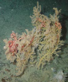
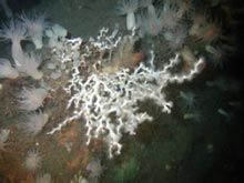
Continuing upslope, we noted the same gradual change in bottom composition to more solid substrates until, at the pinnacle of the mound, it was dominated by large carbonate boulders. Our lights illuminated a large tree-like structure near a large boulder, which upon closer examination was revealed to be one of the largest gorgonians that we have ever seen. It stood between 6-7 ft high and its fronds floating serenely in the current beckoned us on. At last, we found our prize! A single colony of healthy, bright white Lophelia pertusa coral glowed from its mount atop another boulder. We were rewarded with several photographs and many sighs of relief. Although we were hoping for vast tangled thickets of Lophelia, at least we now know that it is possible for the coral to live in this cold, dark, rather harsh environment. With this thought in mind, we finished the dive and called the ROV back to the surface.
Many thanks to all of the people who make these types of explorations possible--the crew of our support vessel, the NOAA Ship Ronald H. Brown, the ROV and survey guys (from Sonsub and C&C Technologies) who give us the means to reach these depths, and the NOAA Office of Ocean Exploration team, which provides logistical support both on land as well as at sea.
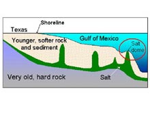
Simplified cross-section showing a slice through the geologic layers under the Gulf of Mexico. The layers shown in this view are about 600 km wide and 15 km thick, so compared to the real dimensions of these units, the diagram is stretched vertically about 13-fold to show detail. The salt domes are also shown wider than they really are. Click image for larger view.
Don’t Take Salt for Granite, I Mean Granted
John Bratton
U.S. Geological Survey
Woods Hole, MA
The habitats found on the sea floor in the modern Gulf of Mexico are the result of millions of years of geologic change, which continues today. The processes responsible can be divided into two groups: those that make the Gulf deeper, and those that make it shallower. The main deepening happened during the Jurassic Period when the granite core of the North American tectonic plate began to separate from South America and Africa over 100 million years ago; this began the formation of the Gulf of Mexico.
A similar process is happening in the Red Sea today, as Africa pulls away from the Arabian Peninsula. The tearing apart of plates does not make an ocean right away. Usually, the big valleys first start to fill as salt deposits form, like those found in the Dead Sea in Israel and Jordan, or the Salton Sea in California. These deposits are called the Louann Salt in the area of the Gulf of Mexico. As the big crack at the bottom of North America widened, the ocean filled the big valley permanently, new ocean crust began to form, sediment began washing into the widening hole from the Mississippi, and other rivers and reefs grew along the shore, burying a width of more than 500 km of salt and the edges of the new crust.
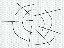
Over millions of years, plumes of the light salt began to float up through the heavier sediment that covered it, like the colored liquid in a lava lamp. As the salt made it very close to the surface, sometimes having traveled through more than 10 km of rock and sediment, it pushed up the sea floor above it to form a mound or dome. After the uppermost salt came in contact with seawater it started to dissolve, sometimes leaving behind a depression with curved cracks around the edges, or cracks radiating out from the center. These cracks are called faults, and if both types are present, a pattern like a spider web is formed. The faults cause certain parts of the sea floor above the salt dome to stick up higher than others.
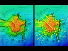
Bright Bank, an underwater salt dome on the continental shelf of the Gulf of Mexico, showing relative height above the sea floor, or depth below the surface of the ocean. The warm colors are highest (or shallowest) and the cold colors are lowest (or deepest). The steepest features on the bank indicate the presence of faults, as shown by the yellow lines in the right-hand panel. The high points tend to be covered by coral because these locations have the strongest currents and get the most sunlight. Shallow-water corals do not photosynthesize themselves like plants do, but they host helpful algae that do and that benefit the corals. Click image for larger view.
These hills and bumps provide excellent spots for corals and other filter feeders to attach themselves, maximizing the current that passes by them and the food they can catch and eat, but giving them a secure place to anchor themselves. The fault cracks also provide pathways along which fluids can migrate to the sea floor, carrying dense salty water and dissolved gases as they seep out. The seeps carry dissolved minerals as well, which precipitate at the sea floor, forming rocky mounds of limestone. If the salt dome is shallow, corals that contain photosynthetic algae can get enough light to thrive there. Deeper salt domes with no light sometimes support organisms that produce energy using the dissolved gases seeping out of the faults, especially hydrogen sulfide and methane, through a process that can make food in the dark, called chemosynthesis. Other sea floor creatures simply use the deep domes as elevated attachment points -- hard islands in a vast region of otherwise muddy sediments. Without the foundation laid by the movement of salt deposited millions of years ago, most of the shallow and deep coral communities we have visited on this cruise would not be present.


