Side-Scan Sonar
Side-scan sonar is a category of active sonar system for detecting and imaging objects on the seafloor. The multiple physical sensors of the sonar — called a transducer array — send and receive the acoustic pulses that help map the seafloor or detect other objects. This array can be mounted on the ship’s hull or placed on another platform like a towfish.

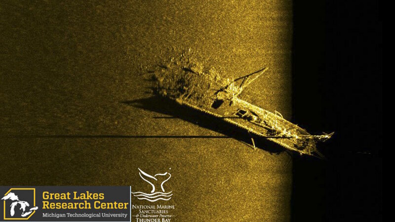
Side-scan sonar image of schooner Typo, which collided with steamer W.P. Ketcham in October of 1899. The schooner, which was carrying a cargo of coal, was rammed in the stern. The sonar image shows the bow and upright foremast, cargo hatches across Typo’s deck, and the broken stern with a pile of spilled coal. Image Source: Michigan Technological University Great Lakes Research Center. Image courtesy of the Michigan Technological University Great Lakes Research Center. Download larger version (jpg, 561 KB).
How does it work?
As the ship moves along its path, the transducer array sends out signals on both of its sides, sweeping the seafloor like the fan-shaped beam of a flashlight. Side scans search at constant speeds and in straight lines, allowing the ship to map the ocean bottom as it travels. The towfish will record data at different sound frequencies, depending on the survey goals: a lower frequency (50 kilohertz (kHz) -100 kHz) can cover large swathes of the seafloor at low image resolution. Higher-frequency pulses (500 kHz to 1 megahertz) record smaller areas but in much greater detail.
The resulting “picture” from side-scan sonar data is made up of dark and light areas. Hard objects protruding from the bottom send a strong echo and create a dark image. Shadows and soft areas, such as mud and sand, send weaker echoes and create light areas. These dark and light images help scientists create accurate maps of the seafloor.

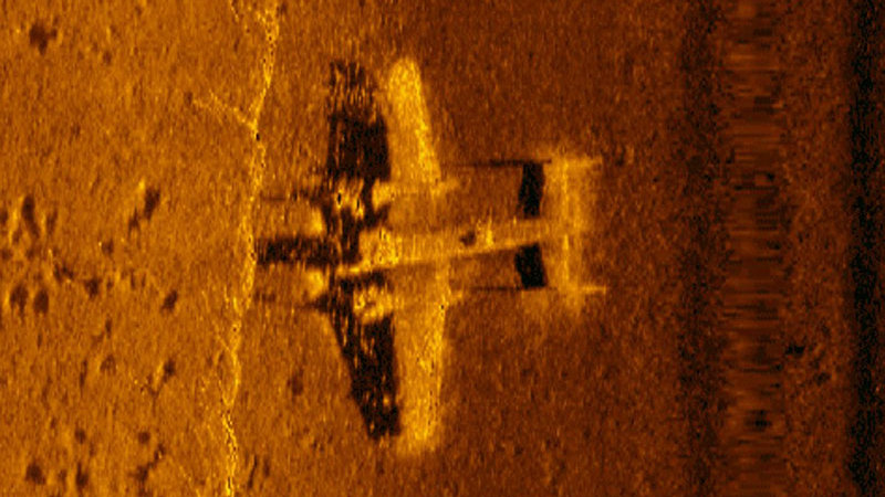
A high resolution side-scan sonar image of a WWII B-25 discovered in 2017 in Papua New Guinea. Image courtesy of Project Recover NOAA. Download larger version (jpg, 639 KB).
Why is it used?
As a specialized sonar system, side scan has particular benefits. This system is often used to map cultural heritage sites like shipwrecks, to characterize the makeup of the seafloor, and can even be used to help biologists identify habitats of marine animals. Side scan is sometimes chosen for an expedition because it is less expensive to run than, for example, a remotely operated vehicle with a high-definition camera. In this way, scientists are able to efficiently cover a lot of ground.
Side scan cannot measure bathymetry (depth), so it is often used in tandem with depth-measuring tools such as single-beam and multibeam sonar in order to create a more comprehensive map of the seafloor.
Text adapted from Side-Scan Sonar at the Edge mission log (2002).
SONAR, short for SOund NAvigation and Ranging, is a tool that uses sound waves to explore the ocean. Scientists primarily use sonar to develop nautical charts, located underwater hazards to navigation, search for and identify objects in the water column or seafloor such as archaeology sites, and to map the seafloor itself. With a sonar survey, a platform is equipped with a group of physical sensors, called a transducer array. This array emits an acoustic signal or pulse of sound into the water. If an object is in the path of the sound pulse, it bounces off the object and returns an “echo” to the array. The array can then measure the strength of the signal. By determining the time between the emission of the sound pulse and its reception, the range and orientation of the object can be determined.


