NOAA Ship Okeanos Explorer
October 5-November 20, 2019

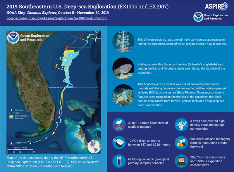
This infographic provides a snapshot of the 2019 Southeastern U.S. Deep-sea Exploration by the numbers. Courtesy of the NOAA Office of Ocean Exploration and Research. Download pdf version (pdf, 1.2 MB).
The 2019 Southeastern U.S. Deep-sea Exploration was a 43-day, two-part expedition led by the NOAA Office of Ocean Exploration and Research (OER) on NOAA Ship Okeanos Explorer. Its purpose was to collect critical baseline information about largely unexplored deepwater areas of the Southeastern U.S. continental margin. It addressed scientific themes and priority areas suggested by scientists and managers from NOAA, management agencies in the region, other federal agencies, and the ocean science community. During this expedition off the coasts of South Carolina, Georgia, and Florida, the expedition team mapped and explored a variety of habitats and features, including coral mounds, terraces, slopes, escarpments, and boulders.
Major accomplishments of this expedition are summarized on this web page. For more information, download the summary fact sheet (pdf, 4.0 MB).
During the 2019 Southeastern U.S. Deep-sea Exploration, we were lucky enough to explore two mound features that revealed extensive, healthy Lophelia coral reefs. These structures could be thousands of years old, yet prior to this expedition, no one knew they were even there. Video courtesy of the NOAA Office of Ocean Exploration and Research, 2019 Southeastern U.S. Deep-sea Exploration. Download larger version (mp4, 204.5 MB).
Deep-sea (cold-water) corals and sponges were observed on all 12 of this expedition’s remotely operated vehicle (ROV) dives, most of which (7) were in protected areas managed by the South Atlantic Fishery Management Council: the Stetson-Miami Terrace Deepwater Coral Habitat Area of Particular Concern and the Pourtalès Terrace Deepwater Coral Habitat Area of Particular Concern. During three of the ROV dives (Dive 02, Dive 06, and Dive 10), including one outside of a protected area, the team found high-density communities of deep-sea corals and sponges.
At one of the sites, targeted based on their newly collected mapping data, the team discovered two deep-sea coral mounds. At another, they explored what these new maps suggest might be the eastern edge of the Million Mounds region, which is currently believed to be the largest area of Lophelia coral reef habitat in U.S. waters.
Corals and sponges provide shelter, food, and nursery habitat for a variety of marine animals, including commercially important fish and other invertebrates. They also provide other services that we are just beginning to understand (e.g., some produce substances that have benefits for human health). With each ROV dive we gain valuable information needed to help protect and manage these important and sensitive deep-sea resources.
Findings from this expedition build on previous OER and partner expeditions to the region, including Windows to the Deep 2018, Windows to the Deep 2019, and the 2018 Deep Sea Exploration and Research of Coral/Canyon/Cold seep Habitats (DEEP SEARCH). They increase our knowledge about the extent and density of these habitats and the animals that call them home. To further this knowledge and better understand how species are related throughout the Atlantic Basin, the expedition team collected 16 samples of corals and sponges that have been specifically targeted for additional research.
This giant isopod (Bathynomous giganteus) was seen snacking on a fish head during Dive 11 of the 2019 Southeastern U.S. Deep-sea Exploration. These deep-sea scavengers are close relatives of the pill bugs, rolly pollies, and sowbugs found in houses and gardens, but Bathynomus giganteus is much, much larger, growing up to a foot and a half in length. Although giant isopods have been known to exist for more than a century, we still don't know all that much about their biology or behavior, making capturing videos like this one incredibly important (and also really cool). Video courtesy of the NOAA Office of Ocean Exploration and Research, 2019 Southeastern U.S. Deep-sea Exploration. Download larger version (mp4, 74.3 MB).
The expedition team used ROV Deep Discoverer to collect biological and geological samples to learn more about the habitats explored. They did so in accordance with the sampling philosophy used on all Okeanos Explorer expeditions, weighing input from participating scientists and balancing operational goals of each dive.
Of the 69 biological samples collected on this expedition, 50 represent potential new species, range extensions of animals not previously known to live in the region, dominant species at a given ROV dive site, and/or rare forms of known species. Potential new species included a number of sponges (including carnivorous sponges), corals, sea stars, and a yellow mesh fan-shaped bryozoan.
The team also observed some unfamiliar or rarely seen behaviors, including a sea spider (Pycnogonida) with its young; a blind lobster (Acanthacaris caeca) waving a small piece of organic tissue, perhaps as bait while fishing for prey; a sea star (Henricia sp.) feeding on a carnivorous sponge; a giant isopod (Bathynomus giganticus) swimming through the water clutching a fish head; and a sea pen (Calibelemnon sp.) retracting into a burrow in the seafloor when intentionally prodded by the ROV’s manipulator arm.

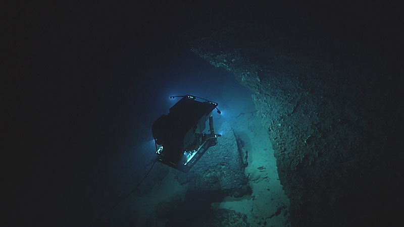
Imaged by its camera sled ROV Seirios, ROV Deep Discoverer explores some interesting, yet potentially dangerous, geology on the Pourtalès Terrace during Dive 10 of the 2019 Southeastern U.S. Deep-sea Exploration. Image courtesy of the NOAA Office of Ocean Exploration and Research, 2019 Southeastern U.S. Deep-sea Exploration. Download larger version (jpg, 304 KB).
During this expedition, the team explored a variety of geological features. These included terrace-like plateaus with overhangs that were covered with life, both on top and underneath, and features that bathymetry suggested might be deep-sea coral mounds but were actually large boulders associated with an adjacent escarpment and pieces of an eroded plateau.
In addition, they explored in and around an area historically subject to the use of experimental deep-sea mining technologies to document signs of disturbance and gather data about the current state of its geology and biology. This dive site was identified in collaboration with the U.S. Geological Survey (USGS) and the Bureau of Ocean Energy Management (BOEM) and based on mapping data collected during Windows to the Deep 2019 and historical data from USGS.
Geological samples collected included sediment, ferromanganese-encrusted cobbles, and rocks. These samples will be used to better understand the geological history of the region and to identify and evaluate the properties of a site’s substrate, which is the surface or material that underlies the habitat and to which deep-sea animals, like corals and sponges, attach themselves.

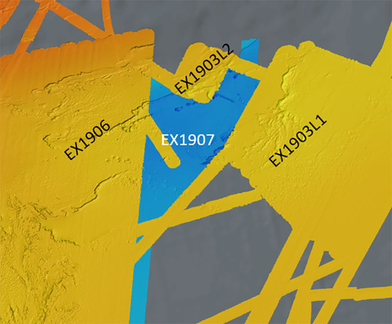
Taking advantage of weather days during the 2019 Southeastern U.S. Deep-sea Exploration (EX1907), the Mapping Team was able to fill in an unmapped area and merge it with mapping data from three previous NOAA Ship Okeanos Explorer missions in the region: Windows to the Deep 2019 legs one and two (EX1903L1 and EX1903L2) and the first part of the 2019 Southeastern U.S. Deep-sea Exploration (EX1906). Image courtesy of the NOAA Office of Ocean Exploration and Research. Download image (jpg, 82 KB).
Ocean mapping is the first step in exploring our ocean. Mapping supports ROV dive site selection and is critical to understanding, managing, and protecting the ocean and its resources and uses. It is a key element of every expedition on the Okeanos Explorer and is conducted in support of Seabed 2030 , an initiative that aims to produce the definitive map of Earth’s ocean floor.
During the expedition, the team mapped high-priority areas identified by USGS, BOEM, NOAA, the Southeast Atlantic Fishery Management Council, and the DEEP SEARCH project. Using high-resolution sonars, they mapped more than 33,000 square kilometers (12,741 square miles) of seafloor, an area larger than the states of Maryland, Delaware, and Rhode Island combined. This included 29,939 square kilometers (11,560 square miles) in the U.S. Exclusive Economic Zone (EEZ), of which 5,129 square kilometers (1,980 square miles) were in the two protected areas, and 912 square kilometers (352 square miles) in the Bahamas EEZ. Also worth highlighting, the team mapped thousands of new mound features that are likely deep-sea coral mounds and filled in an unmapped area and merged it with mapping data from previous expeditions.
Data collected during this expedition included navigational, geophysical, and oceanographic data as well as physical samples, high-resolution videos, images, and detailed ROV dive summaries. Collectively, these publicly accessible data will help scientists identify and evaluate the natural and cultural resource properties of the sites visited. A direct link to the expedition data archive will be provided on the expedition website when the data become available.

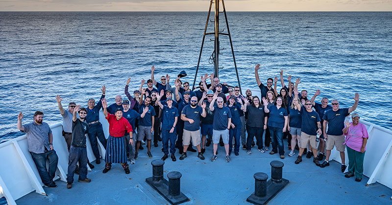
The mission team and crew gathered for a group photo during the 2019 Southeastern U.S. Deep-sea Exploration. Image courtesy of Art Howard, Global Foundation for Ocean Exploration, NOAA Office of Ocean Exploration and Research, 2019 Southeastern U.S. Deep-sea Exploration. Download image (jpg, 4.7 MB).
The Okeanos Explorer is equipped with technology that allows the expedition team to live stream video of the ROV dives and connect onshore scientists to the activities taking place at sea. More than 50 scientists and resource managers from 30 institutions around the world participated in the 2019 Southeastern U.S. Deep-sea Exploration – most of them from shore. The same technology that enabled them to participate remotely allowed anyone with a computer/mobile device and an Internet connection to join in the expedition and experience deep-sea exploration and the wonders of science and discovery in real time. Ship tours, ship-to-shore live interactions, and an expedition-specific website also extended the expedition’s reach beyond that of the participating scientists, opening a window of understanding into the deep sea for audiences worldwide.
The 2019 Southeastern U.S. Deep-sea Exploration is one of several expeditions led by the NOAA Office of Ocean Exploration and Research on NOAA Ship Okeanos Explorer that contribute to the Atlantic Seafloor Partnership for Integrated Research and Exploration (ASPIRE). ASPIRE is a major multiyear, multinational collaborative field campaign focused on raising collective knowledge and understanding of the North Atlantic Ocean. Major expedition accomplishments are aligned with ASPIRE goals.