The Atlantic Seafloor Partnership for Integrated Research and Exploration, or ASPIRE, is a major multi-year, multi-national collaborative ocean exploration field program focused on raising collective knowledge and understanding of the North Atlantic Ocean. The campaign will provide data to inform and support research planning and management decisions in the region.
ASPIRE was a major multi-year, multi-national collaborative ocean exploration field program focused on raising collective knowledge and understanding of the North Atlantic Ocean. The campaign provides data to inform and support research planning and management decisions in the region. Building on the successes of the 2012-2013 Atlantic Canyons Undersea Mapping Expeditions (ACUMEN), NOAA’s ASPIRE campaign broadened the geographic focus to include more of the U.S. Atlantic and the high seas, and the scope of partnerships to include other U.S. Federal agencies as well as international partners from the European Union and Canada.
The ASPIRE campaign provides a foundation of publicly accessible baseline data to increase understanding of the North Atlantic Ocean and critical information relevant to emerging blue economy priorities, including sustainable fisheries, offshore energy and marine minerals, coastal and offshore hazards, and marine tourism and recreation. Video courtesy of NOAA Ocean Exploration. Download larger version (mp4, 186 MB).
Building on the successes of the 2012-2013 Atlantic Canyons Undersea Mapping Expeditions (ACUMEN), NOAA’s ASPIRE campaign will broaden both the geographic focus to include more of the U.S. Atlantic and the high seas and the scope of partnerships to include federal agencies, such as the Bureau of Ocean Energy Management and the U.S. Geological Survey, as well as international partners from the European Union and Canada. Initial ASPIRE fieldwork was conducted in 2016 and 2017, and NOAA Ship Okeanos Explorer will join partners in operating in the region again from 2018 to 2022.

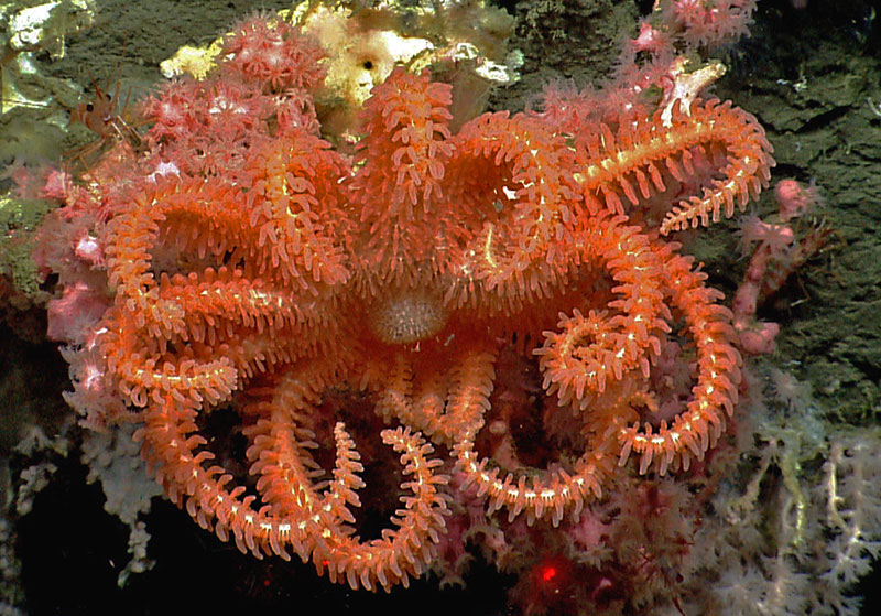
A brisingid seastar rests on a small bubblegum coral in Hydrographer Canyon. Image courtesy of the NOAA Office of Ocean Exploration and Research, 2013 Northeast U.S. Canyons Expedition. Download larger version (jpg, 1.2 MB).
The North Atlantic Ocean plays a pivotal role to humankind, providing biological and geological resources, ecosystem services such as seafood production and climate regulation, and a route for trade and travel between Europe and the Americas. The countries bordering the North Atlantic have a long history of scientific collaboration to explore and study their shared marine resources. With increased globalization, efforts to understand, conserve, manage, and defend the maritime commons have become an essential shared responsibility.
However, we have only begun to understand the North Atlantic Ocean’s ecosystems, resources, and oceanography. Much about the seabed bathymetry, geology and mineralogy, and trans-Atlantic connectivity of biological communities remains unknown. With the signing of the Galway Statement on Atlantic Ocean Cooperation in 2013 and the Atlantic Ocean Research Alliance’s deep-sea science and exploration efforts, there is significant momentum within the international community to cooperate on integrated exploration and research.

An octopus mother protects her eggs in Hendrickson Canyon. Image courtesy of the NOAA Office of Ocean Exploration and Research, Our Deepwater Backyard: Exploring Atlantic Canyons and Seamounts 2014. Download larger version (jpg, 1.4 MB).
The ASPIRE campaign will provide a foundation of publicly accessible baseline data to increase understanding of the North Atlantic Ocean. The effort will also provide critical information relevant to emerging blue economy priorities, including sustainable fisheries, offshore energy and marine minerals, coastal and offshore hazards, and marine tourism and recreation.
Specific goals are to:

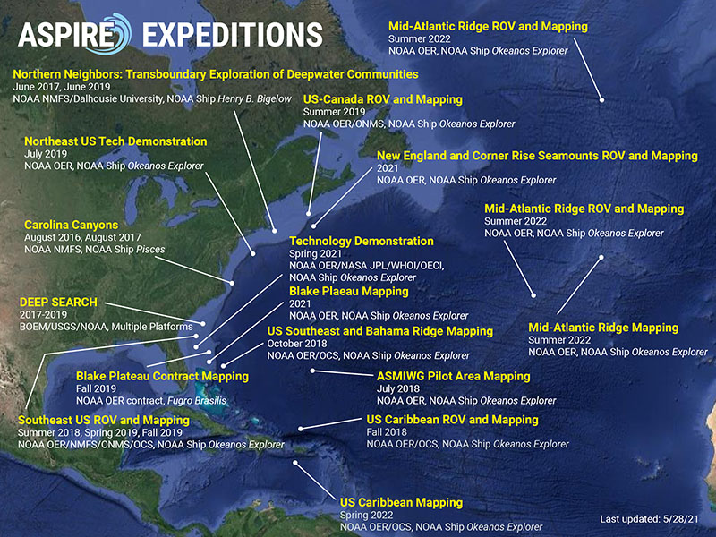
Map of planned ASPIRE expeditions (2016-2021). Image courtesy of the NOAA Office of Ocean Exploration and Research. Download larger version (jpg, 3.6 MB).
ASPIRE expeditions include:
For more information about ASPIRE plans or to discuss potential regional partnerships, please contact Scott France at france@louisiana.edu.