The NOAA Office of Ocean Exploration and Research has postponed its operations on NOAA Ship Okeanos Explorerfor 2020. The ship will enter an extended repair period from November 2020 - March 2021 for required maintenance and technology upgrades. Current expectations are to then resume expeditions in Spring 2021; an updated schedule of activities will be posted as soon as it is available.

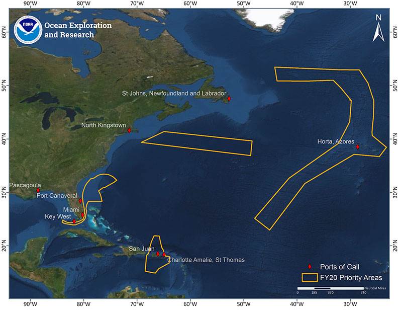
Map showing the operating areas (gold polygons) and ports (red diamonds) for expeditions aboard NOAA Ship Okeanos Explorer to be conducted in FY2020. Three regional expeditions will be conducted in the U.S. Southeast, Caribbean, and Mid-Atlantic Ridge. Image courtesy of NOAA Office of Ocean Exploration and Research. Download larger version (jpg, 3.2 MB).
From October 2019 to September 2020, the NOAA Office of Ocean Exploration and Research (OER) will embark on NOAA Ship Okeanos Explorer to conduct three regional expeditions starting with the U.S. Southeastern Continental Margin, moving to the Northern Caribbean, and finally, the Mid-Atlantic Ridge near the Azores. To commence operations, two expeditions will conduct seafloor mapping and remotely operated vehicle (ROV) operations on the U.S. Southeastern Continental Margin and the Blake Plateau. After a winter repair period, operations will resume with sea trials and shakedown operations off of southern Florida in preparation for the remaining expeditions of the year. An expedition in and around Puerto Rico will be conducted to map deepwater areas in support of Seabed 2030. Departing the U.S. Caribbean, a three-leg ROV and mapping expedition will be performed along the Mid-Atlantic Ridge and the Azores Plateau. The fiscal year will conclude with a mapping expedition of international deep waters in the North Atlantic before returning to home port in North Kingstown, Rhode Island.
Multidisciplinary teams of scientists, technicians, and engineers will conduct undersea mapping and ROV explorations of the geological, biological, oceanographic, and archaeological resources of these ocean areas, the majority of which remain largely unexplored. These expeditions will contribute to the Atlantic Seafloor Partnership for Integrated Research and Exploration (ASPIRE) support of the Galway Statement on Atlantic Ocean Cooperation . NOAA is proud to partner with Canada and the European Union in support of the Galway Statement. The Galway Statement is an initiative between the United States, Canada, and the European Union to advance knowledge of the Atlantic leading to improved ocean stewardship and understanding. Field operations will target largely unknown or poorly understood areas, and will be designed to build on previous efforts to help fill knowledge gaps.
Throughout the year, telepresence technology will allow you to follow discoveries via the NOAA Office of Ocean Exploration and Research website, putting the unexplored ocean in front of your eyes. NOAA is currently seeking scientists and managers interested in actively participating during 2020 expeditions. For details on opportunities to get involved, please visit this page. If you are interested in providing input into expedition planning or participating as a scientist or student, please contact the Expeditions Science Advisor, Dr. Scott France, at france@louisiana.edu.

Map showing the operating area (gold polygon) and ports (red diamonds) for the 2020 OER NOAA Ship Okeanos Explorer expeditions focused on mapping and exploration of the U.S. Southeastern Continental Margin. Image courtesy of the NOAA Office of Ocean Exploration and Research. Download larger version (jpg, 353 KB).
From October 5 through November 20, 2019, OER will conduct expeditions with NOAA Ship Okeanos Explorer focused on mapping and exploring deep waters off the U.S. Southeastern Continental Margin and the Blake Plateau. This region has extensive, yet poorly known deep seafloor and midwater habitats, as well as unique geological features. Operations will focus on exploring the Blake Plateau, Blake Escarpment, and carbonate terraces around Florida. Specific areas to be explored include coral mounds in the Stetson-Miami Terrace Deepwater Coral Habitat Area of Particular Concern (HAPC), an area historically subject to the use of experimental deep-sea mining technologies, and areas in and around the Pourtalés Terrace Deepwater Coral HAPC. Data from this expedition will enable scientists and managers to build a better understanding of the diversity and distribution of deepwater habitats in this region, allowing for informed resource management decisions.
Ship Maintenance and Sea Trials
From December 9, 2019 through February 16, 2020, NOAA Ship Okeanos Explorer will undergo a maintenance period to improve the material condition of the vessel and complete high-priority repairs. This will involve work on the mission spaces that house mapping and ROV systems, as well as installation of a new EM304 multibeam sonar. After work on the ship is completed, OER will commence 2020 operations on March 25, 2020 with extensive testing of the mapping and ROV systems to ensure maximum reliability of the systems and high quality data collection for the rest of the field season.
These shakedown operations are expected to run through April 24, 2020 and will include testing and evaluating the readiness of mission systems, including calibration of the EK60/EK80 split-beam sonars used for mapping operations, the antenna array used for precision ship positioning, the ultra short baseline (USBL) sonar used for positioning during ROV operations, and network and satellite connections used for telepresence, as well as field testing the newly installed EM304 multibeam sonar that will upgrade mapping efficiency. Several ROV engineering dives will be completed to test the reintegrations and upgrades made during the winter repair period.

Map showing the planned operating area (gold polygon) and ports (red diamonds) for the 2020 OER NOAA Ship Okeanos Explorer expeditions focused on mapping in and around Puerto Rico in support of Seabed 2030. Image courtesy of the NOAA Office of Ocean Exploration and Research. Download larger version (jpg, 373 KB).
From May 4 through May 24, 2020, we plan to explore and map deep waters in and around Puerto Rico. This involves collaborations with NOAA’s Office of Coast Survey and will help fulfill a request from the Meso American-Caribbean Sea Hydrographic Commission (MACHC) to acquire bathymetry in areas with substantial gaps in coverage.

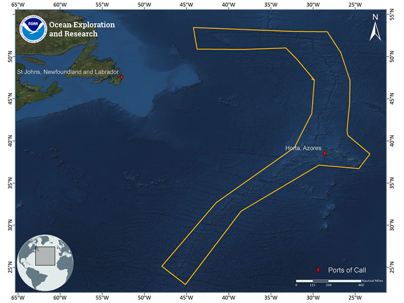
Map showing the general operating area (gold polygon) and ports (red diamonds) for the 2020 OER NOAA Ship Okeanos Explorer expeditions focused on mapping and exploration of the Mid-Atlantic Ridge. The expedition will start in the southern region and work north. Image courtesy of the NOAA Office of Ocean Exploration and Research. Download larger version (jpg, 407 KB).
From May 31 through August 20, 2020, OER will use NOAA Ship Okeanos Explorer to conduct a 70-day expedition to characterize unexplored areas of the Mid-Atlantic Ridge and the Azores Plateau. Bisecting the Atlantic basin, the Mid-Atlantic Ridge extends for approximately 10,000 miles and features a rift valley at its center that is about the depth and width of the Grand Canyon. The Mid-Atlantic Ridge contains numerous hydrothermal vent fields, fracture zones, ridge seamounts, and dynamic plate boundaries. This region is of great interest to resource managers and scientists as they try to understand the connectivity of sensitive marine habitats, such as deep-sea coral and sponge ecosystems, across the Atlantic.
In addition to supporting science and management priorities of this region, this expedition will also address other ASPIRE priorities, such as leveraging international partnerships to conduct coordinated exploration across the North Atlantic Ocean in support of the Galway Statement. ROV and mapping operations conducted during this expedition will complement previous and upcoming work in the region. Mapping operations will target seafloor and water column areas with little or no high-quality sonar data and support follow-on ROV operations. ROV dives will characterize hydrothermal vents, deep-sea coral and sponge communities, fracture zones, and rift zones.

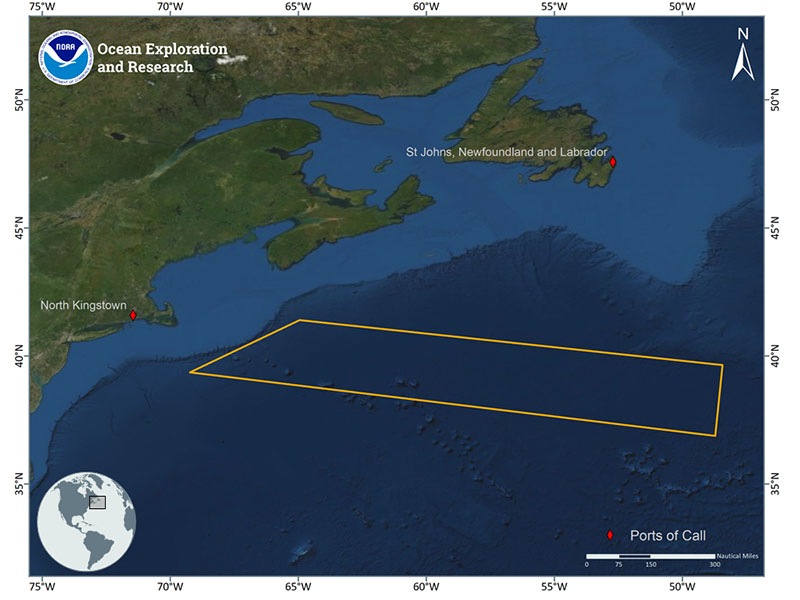
Map showing the operating area (gold polygon) and ports (red diamonds) for the 2020 OER NOAA Ship Okeanos Explorer expedition focused on mapping international deep-sea regions in the Sohm Plain. Image courtesy of the NOAA Office of Ocean Exploration and Research. Download larger version (jpg, 364 KB).
From August 27 through September 12, 2020, OER will conduct a mapping expedition on the NOAA Ship Okeanos Explorer to fill data gaps in multibeam bathymetry coverage in support of Seabed 2030, ASPIRE priorities, and critical marine mineral inventory initiatives. Transit mapping will be planned to match and expand existing track lines en route to home port in North Kingstown, Rhode Island.