by Katharine Egan, Sea Grant Knauss Fellow, NOAA Office of Ocean Exploration and Research
July 2, 2019

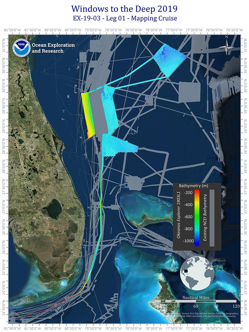
Figure 1: Areas mapped during Leg 1 of the Windows to the Deep 2019 expedition off the southeastern United States. The rainbow colored areas are the new areas mapped during Leg 1 of the expedition, and the grey areas represent existing seafloor mapping data from the NOAA National Centers for Environmental Information. Image courtesy of Kitrea Takata-Glushkoff, OER Explorer-In-Training, Windows to the Deep 2019. Download larger version (jpg, 5.7 MB).
During the first leg of the Windows to the Deep 2019 expedition, we conducted 24-hour mapping operations in deepwater areas offshore of the southeastern United States. After 17 days at sea, we ended the mission with new multibeam bathymetry maps of areas of the Blake Plateau (Figure 1). Mapping operations involved the use of the ship’s deepwater mapping systems to collect baseline seafloor and water column data.
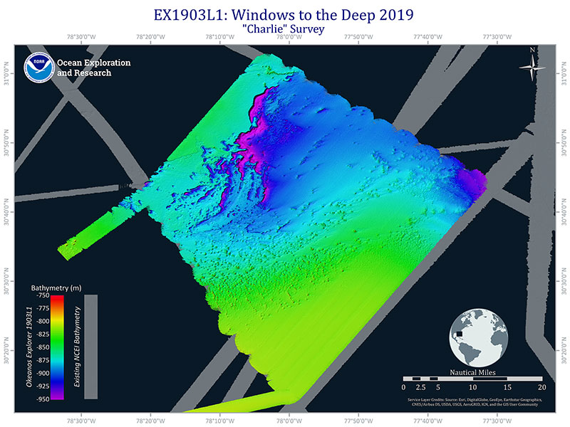
The NOAA Office of Ocean Exploration and Research (OER) is committed to mapping these areas and other deep waters (those 200 meters and below) of the U.S. Exclusive Economic Zone (EEZ). Data collected from mapping operations can provide information that can help inform geological characteristics of the seafloor (Figure 2), physical properties of the water column, essential fish habitat, maritime heritage or archaeological sites, environmental change assessments, mineral and resource extraction, oil and gas development, underwater geohazards, and habitat suitability models. The wider scientific and management communities can then use these mapping data to make informed decisions about ocean resources of interest.

Figure 2: A survey area on the Central Blake Plateau, mapped during the first leg of the Windows to the Deep 2019 expedition. The seafloor mapping data revealed unique geological features in the northwestern part of the survey area, particularly a unique underwater cliff-like structure with a vertical drop of approximately 200 meters (656 feet). Image courtesy of Kitrea Takata-Glushkoff, OER Explorer-In-Training, Windows to the Deep 2019. Download larger version (jpg, 3.5 MB).
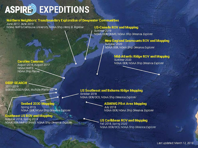
OER is mapping deep waters of the U.S. EEZ by working systematically in a region under an overarching campaign strategy. Currently, OER is focused on the Atlantic Seafloor Partnership for Integrated Research and Exploration (ASPIRE) campaign, which is a multi-year and multi-national collaborative effort to map and characterize the deep waters of the Atlantic Ocean.
The mapping operations of Leg 1 of the Windows to the Deep 2019 expedition contributed to this campaign with the mapping of large swaths of the Blake Plateau, one of the least-mapped areas on the U.S. East Coast. Aside from being used to guide remotely operated vehicle (ROV) operations, these new data will serve as the foundation for site characterization and inform habitat suitability models, as much of the areas mapped were previously excluded from models due to a lack of data.
Past OER campaigns have included: the Atlantic Canyons Undersea Mapping Expeditions (ACUMEN) campaign, which focused on mapping in the North Atlantic Ocean from 2012 - 2013; and the Campaign to Address Pacific monument Science, Technology, and Ocean NEeds (CAPSTONE), where site characterization focused on the U.S. Pacific from 2015 - 2017.

Figure 3: Map of currently identified ASPIRE expeditions (2016-2020). Image courtesy of the NOAA Office of Ocean Exploration and Research. Download larger version (jpg, 495 KB).
The campaign construct allows OER and participating partners to explore the unique features of the U.S. EEZ in the different ocean basins. The mapping data specifically collected on these expeditions contributes towards two other projects that OER is dedicated to supporting: Seabed 2030 and the U.S. Extended Continental Shelf (ECS) project.
Seabed 2030 is a collaborative project between the Nippon Foundation of Japan and the General Bathymetric Chart of the Oceans (GEBCO) that aims to bring together all available bathymetric data to produce a map of the world ocean floor by 2030. The mapping data that OER collects feeds directly into the Seabed 2030 effort.
The U.S. ECS Project is focused on helping the United States identify the extent of continental shelf over which it can exercise sovereign rights beyond the nation’s 200 nautical mile EEZ, consistent with the Law of the Sea Convention . Since 2007, NOAA and a consortium of 13 other U.S. agencies have been collaborating to gather and analyze field survey data, legal data, and seafloor samples to determine the United States' shelf outer limits. OER, the NOAA Office of Coast Survey, and the University of New Hampshire/Center for Coastal Ocean Mapping/Joint Hydrographic Center have been critical partners responsible for conducting the requisite bathymetric mapping surveys.