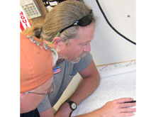
Thomas J. Loebel (center) and C. Andrew Hemmings (left, wearing orange scarf) plan the orientation of the track lines and the dimensions of the "box" for side-scan sonar and subbottom profiling over Ray Hole Sink. Click image for larger view.
Ray Hole Springs Survey
July 28, 2009
![]() Watch a slideshow of the towfish side scan and subbottom profiler.
Watch a slideshow of the towfish side scan and subbottom profiler.
Today, we conducted a remote-sensing survey of Ray Hole Springs, a freshwater spring and cave system located 32 kilometers (20 miles) offshore. First reported by the Florida Bureau of Geology in 1976, the spring was described as a rocky opening in the seafloor that reportedly reached up to 30 meters (98 feet) in depth. Ray Hole was briefly visited three times from 1986 to '92 by archaeologists and volunteers who were able to conduct only limited investigations. During this work, the spring was reported as being clogged with sediment and debris. Several possible artifacts were recovered, as well as some oyster shells and a piece of wood from a live oak tree which turned out to be over 8,200 years old! This provides good evidence of just when this particular area was last dry land.
The purpose of our survey is to obtain good side scan and sub-bottom imagery of a known type of submerged geologic feature, which is also a possible archaeological site. Having this kind of data will help us to identify other possible springs, caves, and areas of interest for further exploration by our dive team.
After we completed sonar scanning of the area, a review of the data revealed several targets of interest. However, we were unable to locate the spring opening during a series of exploratory dives. Hand excavation of the bottom exposed 60 centimeters (23 inches) of marine sediments (consisting of sand, coral rubble, and broken shell), overlying a limestone surface. It is possible that the spring has been buried by debris introduced by hurricanes that have passed through the area, covering the bottom and making the spring hard to detect.
Despite this, with each survey and each dive, we continue to learn more about the submerged landscape that was once exposed during the last ice-age.
Sign up for the Ocean Explorer E-mail Update List.


