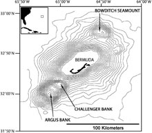
Figure 1. These maps of Bermuda show its location in the North Atlantic (insert) and the orientation and structure of the four peaks comprising the Bermuda Islands and Pedestal, along with the adjacent Argus, Challenge, and Bowditch seamounts. Click image for larger view and image credit.

Figure 2. A cross-sectional view across the Bermuda Pedestal shows the relationship between limestone and volcanic rocks. Click image for larger view and image credit.
Origin of Bermuda and Its Caves
The islands of Bermuda sit atop a long-extinct, mid-ocean volcanic seamount located 1,000 kilometers (600 miles) east of the Carolinas in that part of the North Atlantic Ocean known as the Sargasso Sea. The oceanic crust surrounding the base of the volcano is estimated to have formed 123- to 124-million years ago (mya) at the Mid-Atlantic Ridge, the submarine mountain range running along the axis of the Atlantic Ocean. Extending toward the ocean’s surface are four northeast-to-southwest trending volcanic peaks, including the emergent Bermuda Pedestal and the submerged Challenger, Argus, and Bowditch seamounts (figure 1). The islands of Bermuda are located along the southeast margin of the largest peak, the Bermuda Pedestal.
Several theories have been proposed as to the origin of the Bermuda volcanoes. Initially, scientists believed that a large, underwater volcanic eruption along the Mid-Atlantic Ridge approximately 110 mya established a series of volcanic peaks that moved westward with the North American tectonic plate (as the Atlantic Ocean widened by plate tectonics and seafloor spreading). However, this interpretation is not well supported by the much younger age of volcanic rocks recovered from deep drill cores in Bermuda.
Two Hypotheses
It is now generally accepted that the four peaks comprising the Bermuda seamounts were formed by extensive volcanic activity occurring approximately 33 mya. Why the eruptions occurred at this time and place is still being debated by geologists. One theory hypothesizes that the volcanism occurred over a hot spot or plume in the Earth’s crust. A newer theory proposes that the volcanic activity occurred due to a worldwide reorganization of the planet’s tectonic plates that occurred due to the closing of the Tethys Ocean (when Arabia collided with Eurasia during the Cenozoic Era, 35 to 40 mya). Based on the current area of the Bermuda Pedestal and the maximum elevation of other mid-ocean volcanoes, the elevation of the original Bermuda volcano would have been about 1,000 meters (3.280 feet). Using typical shoreline erosion rates, it would have taken from 3- to 10-million years to reduce the island to sea level.
As the original volcanic peaks of Bermuda were eroded below sea level by wave action, coral reefs formed in the shallows and limestone from calcareous algae and corals began depositing during the early Pleistocene (about 1.8 mya). Today, a thin limestone cap — about 15 to 100 m (49 to 328 ft) thick — completely covers the underlying volcanic rock (figure 2). During the Pleistocene, alternating glacial and interglacial periods, with associated changes in sea-level, resulted in the deposition of a series of limestone layers predominantly composed of carbonate eolianites (remnant sand dunes that were converted to rock), with a few marine deposits and terra-rossa paleosols (red fossil soils composed of wind blown dust from the Sahara Desert in North Africa).
The carbonate eolianites and marine limestones would have formed during interglacial periods of higher sea levels when the platform was submerged, while the paleosols formed during times of glaciation and low sea-levels. Cycles of cementation, erosion, and re-cementation occurred due the fluctuations in sea level. Six to nine interglacial stands are represented in the rock layers that vary in their age and structure.
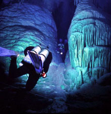
Figure 3. Divers swim between massive submerged stalagmites in Crystal Cave, Bermuda. Such stalactites and stalagmites were formed during glacial periods of lowered sea level when the caves were dry and filled with air. Click image for larger view and image credit.
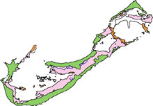
Figure 4. This simplified geological map of Bermuda shows the location for surface outcrops of the Walsingham limestone — the oldest such rock on the island. Click image for larger view and image credit.
The surface of Bermuda is characterized by karst terrain, a landform where the principle weathering process is solution rather than erosion. Karstic areas tend to have exposed bedrock with only a thin layer of soil, few surface streams, and subterranean drainage. The surface karst in Bermuda consists of sinkholes and irregularly shaped pits with complex dissolution channels.
Limestone Cave Formation
More than 150 inland limestone caves are known in and near Bermuda. These caves are believed to have formed during glacial periods when sea levels were 100 to 130 m (328 to 427 ft) lower. During these periods, the entire top of the Bermuda Pedestal was exposed so that the land mass was much larger and the fresh groundwater lens was much more extensive than that of present day Bermuda. As rainwater soaked through the soil, it picked up carbon dioxide to form a weak solution of carbonic acid. This acidic groundwater acted to dissolve the limestone, forming lateral voids. Over time, the dissolution process enlarged these voids to form liner conduits, caves, and underground lakes. Dripping water created massive stalactites and stalagmites in all parts of Bermuda caves (figure 3).
As post-glacial sea levels rose, the air-filled voids within the caves became flooded with sea water and cave formation ceased. Bermuda caves are today characterized by fissure entrances and large breakdown chambers that formed by collapse of roof rock when formerly flooded portions were exposed to air as glacial sea levels fell.
Cave development in Bermuda was mainly confined to the oldest limestone layer known as the Walsingham formation. This rock is characterized by larger sinkholes, crevices, and caves that were formed by dissolution. The Walsingham formation is predominantly found in the interior of Bermuda near inshore bodies of water and it forms a core surrounded by the younger formations (figure 4). The largest outcropping of the Walsingham formation and most of Bermuda’s known caves are located in the strip of land separating Castle Harbour and Harrington Sound.
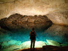
Today, the largest known caves in Bermuda are submerged systems, up to 3 km (1 mile) long, that lie beneath current landmasses. These caves occur primarily at 18 m (59 ft) depth, but extend to a maximum of 25 m (82 ft). Although surface water in inland cave pools is brackish, the water becomes fully marine at depths of several meters (figure 5). Cave tides lag behind ocean tides by up to two and half hours and are reduced in amplitude.
Although all currently known caves in Bermuda are located inland, the existence of offshore, deep-water caves in Bermuda is strongly suggested by geological as well as biological evidence. During glacial low sea stands, subterranean drainage would have been channeled along the contact horizon between soluble limestone and underlying, impermeable basalt (volcanic rock), forming large caves that would now be submerged at depths of 100 m (328 ft) or more.
Blind, Colorless Inhabitants
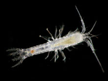
Bermuda’s underwater caves are inhabited by an exceptionally rich and diverse, blind and colorless, native marine fauna, consisting primarily of crustaceans (figure 6). More that 80 new species have been described from Bermuda caves since the early 1980s. Many of these species are primitive, relict (of an earlier time) forms, showing pronounced morphological, physiological, and behavioral adaptations to the subterranean environment that suggests they have been living in caves or similar habitats for many millions of years.
However, all presently known caves in Bermuda were completely dry just 18,000 yrs ago when Ice Age sea levels were at least 100 m (328 ft) lower than today. Also, a number of cave species are still only rarely encountered. Thus, a suitable sub sea level, cave-like habitat must have provided refuge during periods of lower sea level and probably still exists today as the primary habitat for many of Bermuda’s rarer cave species. During periods of Pleistocene glaciations, the land mass and rainwater catchment area of Bermuda would have been about 13 times larger than it is today, resulting in greatly increased water catchment and runoff through caves to the ocean.
Sign up for the Ocean Explorer E-mail Update List.


