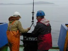
Boris Sirenko of the Russian Academy of Sciences and Sergey Yarosh of the Russian Federal Service for Hydrometeorology and Environmental Monitoring haul in a benthic (sea bottom) trawl during the 2004 RUSALCA mission. Russia's Big Diomede Island (seen in the background) in the Bering Strait is only 4 kilometers (2.5) miles from America's Little Diomede Island. Credit: NOAA.
![]() Click image to view a slide show.
Click image to view a slide show.
Russian-U.S. Arctic Census 2009
August 22 – September 30, 2009
The RUSALCA mission set sail from Nome, Alaska, on the Russian research vessel (R/V) Professor Khromov on August 22 for a 40-day voyage into the Bering Strait and northwards to the Pacific side of the Arctic Ocean. RUSALCA stands for Russian-American Long Term Census of the Arctic; the word rusalca also means mermaid in Russian.
This mission is possible because NOAA and the Russian Academy of Sciences (RAS) signed a Memorandum of Understanding for World Ocean and Polar Regions Studies in 2003. From July 23 to September 6, 2004, the initial collaborative expedition studied the Bering and Chukchi seas. The area is considered particularly sensitive to global climate change, because it is a place where steep temperature, salinity, and nutrient gradients in the ocean meet equally steep temperature gradients in the atmosphere.
The Bering Strait acts as the only Pacific "gateway" into and out of the Arctic Ocean. As such, it is critical for the flux of heat between the Arctic and the rest of the world. Monitoring the flux of fresh water and salt water, as well as establishing benchmark information about the distribution and migration patterns of the life in these seas, are also essential. We need this information before we can place a climate-monitoring network in this region. Arctic scientists are continuously finding new, interesting — and sometimes even alarming — information about changes in the sea ice over time.
The 2009 expedition consists of two legs. On the first leg, from August 22 to 31, scientists will replace eight mooring buoys — the complete mooring chain across the Bering Strait from the United States to the Russian Federation. Data from this mooring array have revealed that water pouring in the Arctic from the Pacific is warming and freshening, and that it is likely contributing to the diminishment of sea ice cover on the Pacific Side of the Arctic Ocean. Partners in this Arctic Gateway flux program include NOAA, National Science Foundation, Russian Academy of Sciences, Roshydromet, and the Russian Federation Hydrographic Services.
The second leg will carry a team of about 50 scientists from the U.S., Russia, and South Korea. On this leg, scientists will track multiple environmental parameters, including seafloor flux of methane from thawing sub-ea permafrost, ocean currents, nutrient pathways, and changes in the benthic (bottom) and water-column ecosystems.
RUSALCA is managed by NOAA's Arctic Research Program with contribution from the Office of Ocean Exploration and Research, and by Group Alliance in Russia.
Additional Information
Click here ![]() for more information on previous RUSALCA activities.
for more information on previous RUSALCA activities.
Click here for a list of blog posts by Reuters reporter Jeffrey Jones, who is onboard the first leg of the 2009 RUSALCA expedition.
Click here ![]()
![]() to read a blog by Betty Carvellas, who is working with Jackie Grebmeier of the University of Maryland Center for Environmental Sciences, and is aboard the expedition.
to read a blog by Betty Carvellas, who is working with Jackie Grebmeier of the University of Maryland Center for Environmental Sciences, and is aboard the expedition.
(Note: By following some of the links found on these pages, you will leave the U.S. Government's NOAA Ocean Explorer Web site.)
You can access the Ocean Explorer Russian-U.S. Arctic Census 2009 News Feed here: ![]()
Updates & Logs
Click images or links below for detailed mission logs and updates.
 Mission Summary RUSALCA is an excellent example of how working together across borders leads to far greater scientific outcomes than either the United States or Russia could have achieved alone.
 September 29 Phytoplankton is an important basic food source in the marine ecosystem. In recent years, many different environmental conditions that affect phytoplankton growth have changed in the Arctic Ocean.
 September 28 It's cold and windy, a typical night in the Chukchi Sea. We are on deck, hauling our elaborate "butterfly net" in by hand, and anxious to see what tiny creatures — known as zooplankton — we have swept up from the ocean's depths.
 September 27 Several things almost certainly occur over the course of a long cruise. A moment comes when things are going so poorly that you ask, “Why do I keep coming out to sea and doing this to myself?”
 September 25Why go to the frigid Arctic when you live in warm and sunny Bermuda? To study CO2, of course!
 September 24 “Nyet fish!” says Nikolai, as we sift through the living treasures freshly brought up from the muddy depths. Actually, there are quite a few small fish mixed in with our haul, but their numbers are overwhelmed by the mound of other critters we have retrieved.
  September 21 Lucky 13: the only sighting of bowhead whales on the RUSALCA cruise so far occurred the morning of September 13, the 11th day of the mission.
 September 18 On the map of proposed stations for this expedition, six sites sit near 75º and 76º N — far north of the other sites. Early this week, satellite maps revealed that the ice had been blown north of these sites, allowing us a rare chance to visit them.
 September 15 The scientists’ gear, instrumentation, and methodologies have been previously tested and proven. Access to Russian waters in the East Siberian Sea and Chukchi Sea is something these scientists value highly and take seriously. So what is going wrong?
 September 14 The sampling stations for the RUSALCA expeditions have precisely pinpointed in advance, but which ones we can actually access is another question entirely - all because of the ice.
 September 11 Aleksey Ostrovskiy, a representative of Group Alliance, the coordinator of the Russian side of RUSALCA, describes his role in the RUSALCA project.
 September 10 For over a day, we have been plowing through what's estimated to be 6 to 8 foot swell in the Chukchi Sea. Heading into it, the ship has cut its speed to about 6 knots (nautical miles per hour) and a number of people have felt the effects of seasickness.
 September 9 You're going to sea in the Arctic for 30 days: what to pack? It's an interesting problem to know you need enough stuff for a month away from home, while also knowing your space onboard will be very limited.
Sign up for the Ocean Explorer E-mail Update List.


