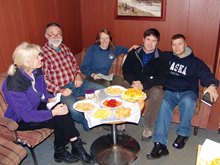
RUSALCA managers and chief scientists onboard the research vessel Lavrentiev, in 2008. Left to right: Kathy Crane, Terry Whitledge, Rebecca Woodgate, Kevin Wood, and Vladamir Smolin. Click image for larger view and image credit.
RUSALCA: Racing the Arctic's Extreme Sea Ice Cover Change
Kathleen Crane
U.S. Mission Coordinator for the RUSALCA program
Arctic Research Program, NOAA
The 2009 Russian-American Long Term Census of the Arctic (RUSALCA) mission, as well as prior RUSALCA expeditions, reflects efforts by the United States and the Russian Federation to develop Climate and Ecosystems Exploration and Observations of the Arctic’s Region of Extreme Sea Ice Cover Change.
Due to the alarming trend in the reduction of Arctic sea ice cover — particularly in the Chukchi Sea located between the Russian Federation (Chukotka) and the United States (Alaska) and northwards into the High Arctic — the Pacific Arctic is arguably the fastest changing region in the world’s fastest changing ocean. Unfortunately, without baseline information about Pacific Arctic oceanographic and ecosystem conditions, it is impossible for us to accurately document the extent of fundamental ecosystem change. The collection and integration of biological, physical, and chemical information during the RUSALCA expeditions are designed to gather information where the summer ice edge is rapidly advancing northwards. These observations will provide a major step toward obtaining the foundation of information necessary for detecting ongoing and future change in this delicate ecosystem.
The RUSALCA mission was developed in 2003 after several years of U.S. government to Russian government discussion about how our two nations could work together in the Arctic waters that straddle the Russian-U.S. border. We, as the “gatekeepers” of this region of the Arctic, have a responsibility to observe changes and to explore together the Arctic world that we share. Our goals were at once simple (technically) and complicated (diplomatically). But what we as scientists shared were the goals of understanding and exploring our mutual world and gathering information needed to predict the global changes that might be consequences of the changes in “our” side of the Arctic.
We designed a program that would include both Russian and U.S. scientists, who worked together on various teams. Their focus ranged from those who examined the biogeography and diversity of fish, Arctic water column species, to seafloor and oceanographic fluxes; and they were concerned with life that spanned from the tiniest microbe to the largest whales.
The questions were — and are still sometimes — very basic.
•What lives here? What is migrating there?
•
How are the currents changing through space and time?
• How much heat is entering the Arctic through the Bering Strait?
•
What is causing the thinning and great reduction is sea ice cover in the Pacific Arctic?
• How can we even address Arctic biodiversity changes until we know which creatures populate the Arctic?
• How can we build on our collaborative efforts to design a more robust Arctic Observing System, one that extends outwards and northwards of the Pacific Arctic to all of the Arctic regions?
Above all, the issues that drive much of our collaboration are related to the fact that the changes in the Arctic are so rapid. Time is of the very essence of our work. We cannot afford to wait another year to address these issues. The original founders of the RUSALCA program in 2003 were the Russian Academy of Sciences and NOAA (a collaboration between the Arctic Research Office and the Office of Ocean Exploration). Since that time, funders and participants from other agencies have joined the effort. From Russia, we now have assistance from the Russian Federation Navy, Roshydromet, the Ministry of Natural Resources, and the private company Group Alliance. On the U.S. side, the National Science Foundation has joined the efforts by helping to support the RUSALCA Bering Strait Moorings, which are serviced on an annual basis.
Through the years, the RUSALCA program has used three different vessels, the research vessel (R/V) Professor Khromov; the Sever, a Russian Naval Hydrographic ship; and the R/V Lavrentiev.
We anticipated that we would repeat the sampling of our stations on a four-year interval, extending them where the sea ice melted. Yet in 2004 we did not anticipate exactly how far back the ice would melt. In 2009 we were able to take the R/V Professor Khromov up to 77 ° N, about 300 nautical miles north of our 2004 stations ,and we were able to take the furthest north trawl for fish in this region of the Arctic. We traversed the waters far enough west to reach the East Siberian Sea. (What the U.S. calls the Western Arctic, Russia calls the Eastern Arctic. This is why the RUSALCA mission has begun to call this region the Pacific Arctic). This year we have commenced observations for ocean acidification in the area of extreme sea ice cover change.
During the six years since we began RUSALCA, we have seen an evolution of both the science and diplomatic protocol designed to assist with transfer of data and samples between our two countries. RUSALCA is an excellent example of how working together across borders leads to far greater scientific outcomes than either one of our countries could have achieved alone.


