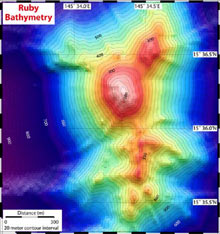
A map of the summit of Ruby volcano, the area of Dive J2-194. The contour interval is 20 m; EM300 bathymetry grid resolution is about 20 m. Click image for larger view and image credit.
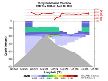
Just below the surface layer at Ruby, a slightly deeper, more concentrated particle anomaly was detected by a light scattering sensor on the CTD (an instrument that measures conductivity, temperature, and depth). Click image for larger view, more information and image credit.
Ruby Submarine Volcano
May 3, 2006
Bob Embley
Geophysicist
NOAA Vents Program, Pacific Marine Environmental Laboratory
The wonderful opportunity we had to observe and sample the active eruption at NW Rota-1 volcano provides a new basis for understanding submarine eruptions on arc volcanoes. It also raises new questions about how these volcanoes work. For example, how often do these volcanoes erupt, how long do they remain active, and how much material is produced during a typical eruptive episode?
In order to better understand these volcanoes, we looked for another example that had a recent eruptive history. In the 1960s, hydrophones (instruments that measure or monitor sound under water) picked up sounds from a point lying northwest of Saipan, the largest of the Northern Mariana Islands. Subsequent mapping showed a shallow volcano in the correct location that was named Ruby. Ruby has had several eruptive episodes since then, with the most recent one occurring in 1995. Although the conductivity, temperature, and depth (CTD) measurements during our Submarine Ring of Fire (SRoF) expedition here in 2003 did not show any evidence of a hydrothermal plume, a tow-yo conducted on this expedition (SRoF'06) did find evidence of hydrothermal emissions. The explorations we made during Dive 194 with the remotely operated vehicle (ROV) Jason found evidence of low level emission of hydrothermal heat and chemicals characterized by extensive iron-oxide crusts and deposits. We also discovered a unique ecosystem living on the upper flank of this volcano, consisting largely of numerous brown/red crabs and small limpets that colonize the small rocks and sand within the iron-oxide zone. Has this community survived the last volcanic eruption on the summit of Rub, or has it developed since? We don't know from our present data, but we now have a good baseline of information that will be invaluable for future investigators studying the aftermath of the next eruption of Ruby volcano.

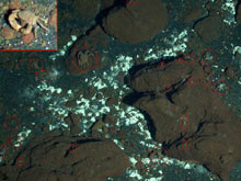
A unique ecosystem lives on the upper flank of Ruby volcano, consisting largely of numerous small brown/red crabs and small limpets that colonize the small rocks and sand within the iron-oxide zone. The inset shows zoomed-in view of one of the crabs, which were hard to distinguish from the surrounding red rocks and sediment. The red circles outline some of the crabs in the image. Click image for larger view and image credit.
The submarine volcanoes of the Mariana arc are slowly revealing their mysteries to us. Stay tuned for the latest from Daikoku, where we found a very exciting new site last night.
Sign up for the Ocean Explorer E-mail Update List.


