Navigating the Aftermath
September 1, 2005
Aric Anderson
Captain - R/V Seward Johnson
Harbor Branch Oceanographic Institution
Latitude: 29° 09.271' N
Longitude: 88° 00.817' W
![]() Scenes of the diversity of life clusters in and around the Lophelia coral at Vioska Knoll. (Quicktime, 888 Kb.)
Scenes of the diversity of life clusters in and around the Lophelia coral at Vioska Knoll. (Quicktime, 888 Kb.)
The Gulf of Mexico is home to thousands of oil production platforms. For the last thirty-five hours we have been underway from the Texas A&M facilities in Galveston, TX to our dive site located at Vioska Knoll, which is approximately 75 nautical miles south of Mobile Bay. Information on the amount of destruction caused by Hurricane Katrina in the oil field is still largely unknown, and, because of this, navigation, especially at night, in this area is potentially very dangerous. For the safety of the ship, the crew, and the scientists onboard, I took a route as we left Galveston much further to the south than I would have chosen under normal situations. Navigating outside of Galveston, we adhered to the established safety fairways that form the shipping lanes between the otherwise (seemingly) random distribution of oil platforms. Once offshore well to the southeast of Galveston, we worked our way along the 500 fathom (3000 ft) curve around to Vioska Knoll.

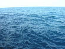
The beautiful blue waters of the Gulf of Mexico, surprisingly calm only 3 days after Hurricane Katrina. Click image for larger view.
Staying in deep water, we were able to avoid the areas where the rigs are most prevalent. And, because of this detour, we have not seen much of the destruction that many had anticipated. What we have witnessed has mainly been limited to lightweight debris that was blown off the rigs. Yesterday we passed hundreds of empty plastic milk jugs that must have found their way out of a dumpster or (hopefully) a recycling container during the hurricane. Shortly after nightfall, the ship was greeted by a half-dozen blinking strobe lights. The lights proved to be standard issue life-ring lights - some of which were attached to rings, others were not. Our ship carries eight such lights distributed at prescribed intervals along the weather decks, and, based on this, I would imagine that they are required about every fifty feet or so around the railings on an oil platform. Fortunately, the oil industry is known to evacuate all personnel off the rigs prior to major storms, so these lights were probably just left outside where they were either washed or blown off of the rigs.
Our arrival back here at Vioska Knoll is less than a week from when we evacuated to avoid Hurricane Katrina. The seas are relatively calm again, but a couple of things have noticeably changed out here. The water temperature at the surface has dropped to 83° from 91° Fahrenheit - possibly due to mixing caused by the wave action or possibly due to the outflow from the Mississippi Delta. And, unfortunately, the horizon has also changed - one of the deepwater rigs in our immediate area has lost its derrick structure. From conversations with other mariners, we have learned that this is not an isolated incident. Many of the rigs that were in the direct path of Katrina have suffered similar fates - including MARS - the largest natural gas platform in the Gulf of Mexico, if not the world.

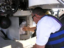
Submersible pilot Hugo Marrero places Styrofoam cups in the battery box of the Johnson-Sea-Link submersible in preparation for the first sub dive since we were forced evacuate in the face of Hurricane Katrina. This box is not pressurized and so anything inside it is subject to the increasing pressure of the water above it as it submerges. Click image for larger view.

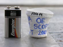
The cups compress and become shrunken versions of their original selves. They are then given to teachers throughout the United States who participate in professional development offerings through NOAA's Office of Ocean Exploration. Click image for larger view.
Click here for more information on styrofoam under pressure.


