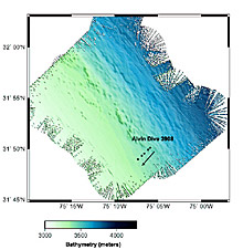
This map shows the results of a Seabeam survey of the northeastern flank (side) of the Blake Ridge and the location of DSV Alvin dive 3908, conducted on 25 July 2003 to explore the geology of this area and to search for signs of past or ongoing methane seepage. Image courtesy of C. Ruppel. Click image for larger view.
Let the Mapping Begin
July 24, 2003
Dr. Carolyn Ruppel, Co-Chief Scientist
Associate Professor
Georgia Institute of Technology
The second day of transit on board the RV Atlantis proved a calmer ride than the previous day. Many of those who were seasick emerged from their rooms ready to perform their tasks, and lines for meals became longer than two or three people. The science party began to assume duties that they will carry out for the duration of the cruise.
Thursday night, scientists began high-resolution seafloor and subseafloor mapping using the Atlantis’ Seabeam 2100 multibeam survey system and the Knudsen 3.5 KHz echosounder or Chirp (because it sounds like a bird) subbottom profiling system. The Chirp sonar system will peer into the shallow sediments using an acoustic pulse that penetrates the uppermost meters of the sediment column, revealing layering and other features at and just below the seafloor. By combining biological and chemical information obtained from the Alvin samples and geophysical data obtained during nighttime mapping, scientists will develop a complete picture of methane and other seeps on both the surface and the subsurface.
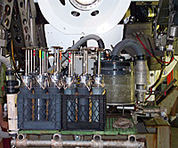
Push cores assembled in Alvin’s basket and ready for the first dive. Photo by M. Olsen. Click image for larger view.
The goals of seafloor and subseafloor mapping in this mission are to acquire high-resolution data that link the pattern of structures observed on the seafloor to underlying geologic structures. Such data, which provide information about sediment layering in the uppermost 20 to 70 m below the seafloor, bridge the gap between seafloor surveys using Alvin and high-resolution geophysical data that image the deep part (hundreds to thousands of meters below the seafloor) of the sedimentary section.
The first Alvin dive of the cruise, dive 3908, will take place on Friday along the northeastern eroded flank (side) of the Blake Ridge. This dive will be the first exploration ever undertaken of this feature. Alvin will begin the dive at ~3,450 m water depth and survey along a 2-km-long transect in a southeastwardly direction along the seafloor. The scientists will record video, make visual observations, collect geologic samples, and search for indications of active or past methane seepage. Older layers of rocks may be exposed at the surface in this area due to erosion, and the scientists will sample any mudstones or carbonates that Alvin encounters. Signs of methane seeps may include active venting of bubbles, bacterial mats, or chemosynthetic communities. If such features are found, the scientists have arranged a push core sampling plan that will provide material for linked studies of the pore water geochemistry, seep ecology, and microbial ecology.
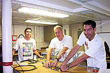
Graduate students Bill Gilhooly, Heath Mills, and Rob Martinez assemble the ‘squeezers’ that will be used to extract pore water from the sediment samples obtained in the push cores. Photo by M. Olsen. Click image for larger view.
In planning for this dive, significant discussion focused on the proper acquisition of push cores. The science observers in Alvin are responsible for filming the complete process of coring, which includes the pilot removing an empty core from the front of the submarine (“the basket”), inserting the core in the sediment, and then returning the core to the basket. The observers also note the number and location of the core and the purpose of the sample. Each night after the dive, scientists remove the push cores and all other samples from the basket on the front of the sub and immediately begin cataloging and processing the material for various studies.
The weather is calm and clear, and all on board are eagerly anticipating the first dive of the cruise.
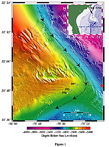
Bathymetric location map of the Blake Ridge study area produced from hydrosweep data obtained during a fall of 2000 cruise. The dashed arrows indicate the flow direction of the Western Boundary Undercurrent. White annotated circles denote Leg 164 drill sites 994, 995, & 997, where free gas and methane hydrate were recovered. The Red Star signifies the general location of the 1st Dive Site. Image by W.S. Holbrook. Click image for larger view.
The First Dive on Blake Ridge:
Site description and the process of site selection
Matthew Hornbach
PhD Student Geophysics University of Wyoming
The Blake Ridge is a well-studied contourite (a sedimentary field where currents have caused bottom sediments to drift -similar to a beach dune system) drift deposit located approximately 450 km east of Savannah, Georgia, that is known to contain hydrate and exhibits a bright, generally continuous BSR (bottom simulating reflector) (Figures 1 & 2). The Western Boundary Undercurrent (WBUC) – a deepwater contour current that sweeps southward along the continental slope from the northwest Atlantic – controls the large-scale structure of the Blake Ridge (Figure 1). With its strong current, the WBUC erodes sediment on the northeastern ridge flank (side) and deposits them on the western flank. The eastern flank of the Blake Ridge therefore consists of an eroded surface where faults extend continuously from below the BSR to the seafloor. With the thick mud sediment eroded off the eastern flank, faults in this area may act as conduits for gas to migrate upward unimpeded from the BSR to the seafloor.
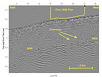
Seismic data obtained over the Dive site during the Blake 2000 cruise along seismic line R39. A key goal of this dive is to determine whether gas escape has played a role in creating the bumpy features at the seafloor as well as disrupted the sediment below. Image by W.S. Holbrook. Click image for larger view.
The seismic data in this region also reveal gas “chimneys” (Figure 2) in which gas overpressure below the seafloor resulted in hydrofracture (i.e., gas overpressures at the BSR caused fracturing of sediment above, enabling gas to escape into the overlying sediments, and possibly to the seafloor). Furthermore, high-resolution 3.5 kHz echo-sounding data along the eastern flank of the Blake Ridge reveal anomalous “mounds” in the vicinity where faults surface and gas chimneys exist. Beneath these mounds the sediment reflections in both seismic and 3.5 kHz data appear weak and the sediment disturbed. Why the sediments appear disrupted, and why these mounds exist remains unclear, and direct geological interpretation of this area would offer helpful insight into their make-up and formation. Perhaps most importantly, because mounding and sediment disruption are observed in known regions of gas escape, we believe the site is a prime location of past and perhaps current gas escape. A low fluid flux passive environment (i.e. an environment under little tectonic activity) like the Blake Ridge is not expected to have significant fluid flow. Any discovery of past or current gas venting (or hydrate formation) at the Blake Ridge seafloor would therefore be significant, since venting is not expected in such settings.


