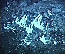
Samples collected at the new vent site included several of the tube worms seen in this photo. It was the dramatic discovery of these large tube worms that launched an entirely new inquiry into our understanding of biological processes in the sea, and beyond. Click image for larger view.
Alvin Still Searching for the Rose Garden
May 27, 2002
Alvin remains tenacious as our search for the Rose Garden area continues. During the search, we have seen a new vent area, populated with mussels, tube worms, and other creatures, covering about 50 square meters. Also, ABE continues to serve the expedition very well, providing detailed images of the bathymetry in the areas of interest, including where the target sight should be. ABE also detected warm water sources, and Alvin was dispatched there to investigate, finding a vent.
ABE has been extremely useful in finding locations for close examination by the submersible. Whether or not the Rose Garden area is still here, ABE will be an important part in helping to determine that. During the night, the ship and science party is using both the CTD to detect warm water sources, and a towed camera sled that photographs the seabed. Because the camera images in this very practical system are not transmitted through the tow cable, we must wait until the towed device is returned to deck to see the images. We look forward to another dive tomorrow.

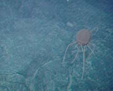
A jellyfish seen during today's Alvin dive No. 3789 in a lava field of unknown age. With just a passing glance at the creature, we could not positively identify it. It is a reminder that at one time, scientists believed that no life existed in the deep sea, simply because light did not exist there. Today we know that many forms of life exist in the deep sea. Click image for larger view.
So why is it so hard to find the Rose Garden?
This site was visited last in 1990, and much could have happened to it since then. New geological events may have occurred in the vicinity of Rose Garden, completely changing its appearance. Or, we may not yet have relocated the original site. But shouldn't it be easy to find a site that has already been visited? Not necessarily. The navigation system we use is more accurate than that used in previous visits. With GPS equipment aboard Atlantis, we can determine very precise positions for the location of bottom features. However, the challenge lies in compensating for the older survey system which may have had its own built-in errors, and may not have pinpointed the location of the Rose Garden accurately. In addition, the bottom may have changed geologically over the last 12 years.
The process of determining our position today is based on mathematical interpretation of the position of transponders that generate electronic acoustic signals, deployed in the vicinity of the work site. The location of these transponders is fixed by GPS coordinates, after the ship performs a series of circles and maneuvers around the transponders to refine our understanding of their position on the bottom. But the transponders must be high enough to clear any submarine features, including the geological features that we are here to explore. Without such elevation and clearance of the seabed, the acoustic signals between transponder and the sub may be obstructed. To prevent this, the transponders are elevated over 100 meters above the bottom. Solving one problem may add another, however, because the elevation may introduce some variability in the positioning of the transponder and all references to it. While these variations would only be slight, measurable in tens of meters, the manner of calibration used just a decade ago may introduce even greater errors between positions, in the hundreds of meters.
Sign up for the Ocean Explorer E-mail Update List.


