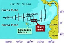
The Galapagos Rift is an area deep in the Pacific Ocean off the west coast of South America. It is the site of the discovery of life at oceanic hydrothermal vents. The 2002 Expedition will bring scientists back to see how the site is changing over time and to explore for new sites. (image courtesy WHOI)
Galapagos Rift Mission Plan
Background
An area deep in the Pacific Ocean, far from the coast of South America, is the site of one of the most important discoveries ever made in ocean science. The discovery of life at hydrothermal vents on the seafloor revolutionized our understanding of life on our planet.
The Galapagos Rift, between longitude 86 degrees W and 89 degrees W, is an area where the sea floor is formed in a rift valley by continent-sized geologic plates that are slowly moving apart. As the plates move, magma from deep inside the Earth is pushed upward and is met by the pressure of a mile and a half of Pacific Ocean bearing down upon it. This dynamic interchange between the earth and ocean creates an environment of extreme heat, pressure, and geologic, volcanic and chemical activity. If you can imagine the inside of a super-huge furnace, at the bottom of the ocean, filled with toxic chemicals and the fury of volcanic heat, then you can begin to imagine the environment of hydrothermal vents. This environment is home to strange sea floor formations, bizarre and undocumented forms of life, and where superheated water jets out of the ocean floor bringing with it a soup of microbial life that flourishes in this extreme environment.

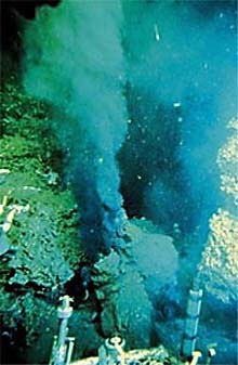
The first “black smoker” hydrothermal vent ever seen by humans was photographed by WHOI scientists in 1979 at 29 degrees N. (photo courtesy WHOI)
The Expedition
The overarching objective of the expedition is to continue long time-series studies at hydrothermal vents and provide an integrated foundation for future studies along the Galapagos Rift. Through an interdisciplinary approach, scientists aim to understand the changes in biological communities, fluid and rock geochemistry, sulfide mineralogy and geological features associated with this mid-ocean ridge hydrothermal system.
The major coordinated components of the program include mapping the distribution and composition of biological assemblages, in situ and laboratory analysis of vent fluid chemistry, geological mapping and sampling around the known vent sites near 86 degrees W, and exploring for additional sites out to 89.5 degrees W, where the Galapagos Rift valley shoals as it approaches the hotspot trace of the Galapagos Islands. Using the latest technology, including the submersible Alvin, the Autonomous Benthic Explorer (ABE), and digital camera systems for night-time remote surveying, scientists and explorers will create new, high-resolution maps of the area, collect biological and mineral samples, and explore for other sites of hydrothermal activity.
Mission Goals
The major goals of the Galapagos Rift Expedition are to:
1. access the temporal and spatial changes that have occurred among and within Galapagos faunal assemblages through a detailed mapping and sampling program;
2. correlate observed variations in faunal and microbial assemblage composition with observed variations in fluid chemistry, sulfide mineralogy and chemistry, pH, and temperature (i.e., nutrition-related properties of the fluids) via extensive biological sampling and in situ and laboratory analysis of fluid chemistry and sulfides;
3. explore the Galapagos Rift for previously undetected high-temperature venting and new vent fields/animal communities using ABE, towed camera systems and conductivity, temperature and depth (CTD) tow-yos. Any new discovery will be mapped and sampled using Alvin and ABE;
4. sample for biological, chemical and mineral species and map any newly discovered site; and
5. develop a comprehensive model of vent community succession at the Galapagos Rift sites. The goal is to use the model to guide the design of future studies and experiments at hydrothermal vent sites.
Sign up for the Ocean Explorer E-mail Update List.


