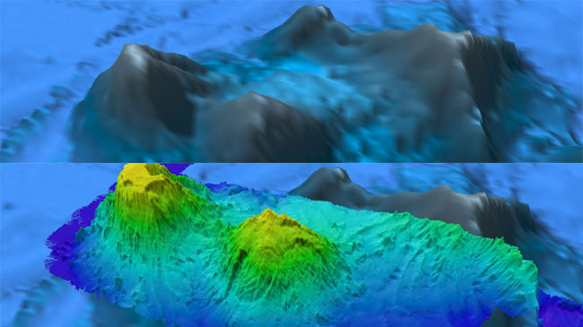
Altimeter data collected using satellites has been used to generate low-resolution maps of 100 percent of the ocean bottom. This dataset is the basis for the seafloor background layer in software like Google Earth. The resolution of this global data is 1.5 kilometers, or about one mile. This means that if any dimension of a seafloor feature is a mile or bigger, we can see it in this map. Maps at this resolution give us an overall general picture of what’s down there, but offer limited detail and can omit things such as volcanic craters or shipwrecks.
Only about five percent of the global ocean has been mapped by modern multibeam sonar systems to provide detailed information about the seafloor. At the resolution of 100 meters (328 feet), these maps may allow us to spot previously unseen features such as seamounts, deep-sea sandwaves, faults, ancient coral reefs, and even new types of features that are currently unknown to science.
Want to detect things that are several meters/feet in size, such as a gas seep or the wreckage of a missing airplane, in deep water (greater than 1,000 meters)? You’ll need even higher-resolution seafloor images obtained through a combination of mapping and direct observation…for which coverage is less than one percent of the entire ocean floor.
So how much of the seafloor is there left to explore, or “uncover”? The answer sort of depends on what you are looking for…

Two newly mapped seamounts in the New England Seamount chain. The seamount on the left side of the image was discovered to be a guyot (gee-yo), which is flat-topped extinct volcano. The flat top indicates that the guyot's summit was above sealevel at some point in its geologic history and was therefore exposed to wind and wave action which planed it off. Also revealed on the seamounts were hundreds of small peaks not visible in scientifically valuable, but low resolution, satellite altimetry. Satellite altimetry gives a first pass look at large features present on the seafloor, but generally does not reveal features smaller than 1.5 km in length or width. Image created using QPS Fledermaus. Satellite altimetry data from Smith, W. H. F., and D. T. Sandwell, Global seafloor topography from satellite altimetry and ship depth soundings, Science, v. 277, p. 1957-1962, 26 Sept., 1997
