
Date: July 11, 2019
Location: Lat: 36.86505°, Lon: -74.48573°
Dive Depth Range: 1,522 - 1,615 meters (4,993 - 5,299 feet)
Access Dive Summary and ROV Data
Highlights from the final dive of the expedition, when we explored the seafloor around a deep seep site in Norfolk Canyon first discovered by the NOAA Office of Ocean Exploration and Research during an Okeanos Explorer expedition in 2012. Learn more about the dive in this mission log. Video courtesy of the NOAA Office of Ocean Exploration and Research, Windows to the Deep 2019. Download larger version (mp4, 111.9 MB).
Today was our last dive of the Windows to the Deep 2019 expedition at a seep site just south of Norfolk Canyon. This deep seep site was first discovered by the NOAA Office of Ocean Exploration and Research using NOAA Ship Okeanos Explorer in 2012. The site is notable because it is one of the deepest locations of methane discharge on the U.S. Atlantic margin and a particularly extensive site, as indicated by acoustic mapping of the water column. Past remotely operated vehicle (ROV) and human operated vehicle observations of benthic communities at seeps approximately 500 meters (1,640 feet) depth to the northwest and 1,000 meters (3,281 feet) depth to the northeast indicated high levels of gas release, robust chemosynthetic ecosystems, extensive beds of Bathymodiolus mussels, abundant carbonate rock, and abundant bacterial mats. The location for the dive today was chosen for its proximity to these previously explored seep sites, with the prospect of finding similar ecological and geological features that would allow for comparison with the seeps nearby.
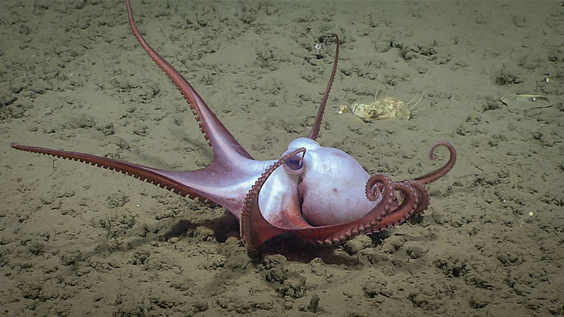
This octopus, Muusoctopus johnsonianus, was seen in Norfolk Canyon during the final dive of the Windows to the Deep 2019 expedition. This species is unique in having reverse countershading, light on top and dark on bottom, when compared to other octopods. Image courtesy of the NOAA Office of Ocean Exploration and Research, Windows to the Deep 2019. Download larger version (jpg, 1.3 MB).
Multibeam mapping was performed the night prior to the dive at the potential dive site to search for the presence of bubbles in the water column. Mapping data did confirm abundant bubble plumes from the previously explored seep sites and apparent smaller plumes near the targeted waypoints. The dive track was slightly modified from the planned track to accommodate some offset between the targets and the mapped bubble plumes. However, as seeps are known to frequently turn on and off, a couple of the points were left the same to ground truth previous acoustic data from which the original dive track was chosen from.
The ROVs reached bottom around 1,615 meters (5,299 feet) depth. The first couple hundred meters of the dive track were mostly soft, silty sediment with some brittle stars, fish (Halosaur and Antimora rostrata), urchins, anemones, sea pens, and empty Bathymodiolus mussel shells. After traveling approximately 200 meters (656 feet), we started to encounter some small bacterial mats followed by some outcrops of authigenic carbonate rocks and live Bathymodiolus childressi mussels. A number of Chimaera were also seen throughout the dive, in addition to some octopods (Muusoctopus johnsonianus) and skates.
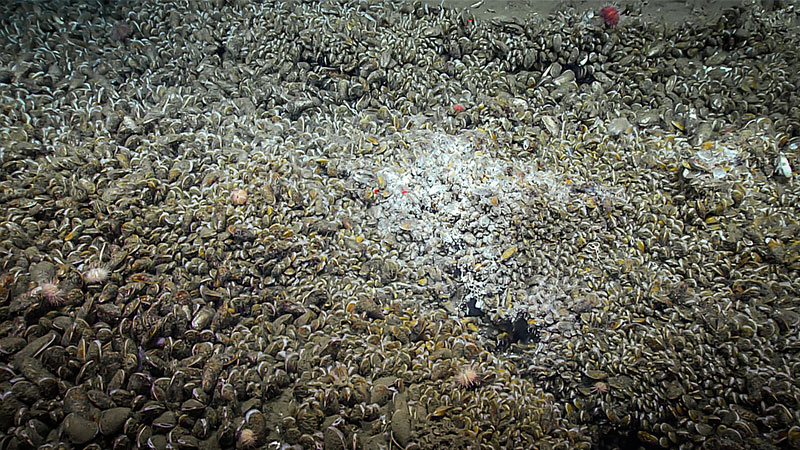
A high abundance of mussels, Bathymodiolus childressi, and bacterial mats were documented about halfway through Dive 19 in Norfolk Canyon during Windows to the Deep 2019. This area was where bubbles were detected in the water column during overnight mapping. Image courtesy of the NOAA Office of Ocean Exploration and Research, Windows to the Deep 2019. Download larger version (jpg, 2.6 MB).
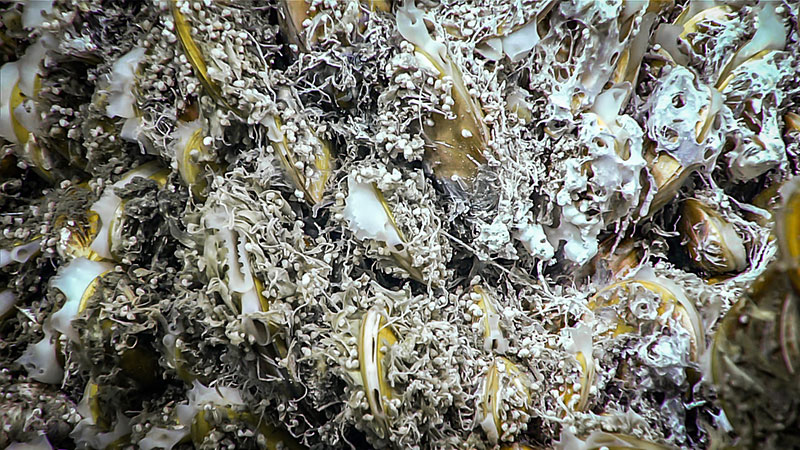
A close-up view of mussels and bacterial mats, documented at a deep seep site in Norfolk Canyon during Dive 19 of the Windows to the Deep 2019 expedition. Image courtesy of the NOAA Office of Ocean Exploration and Research, Windows to the Deep 2019. Download larger version (jpg, 2.1 MB).
A large area of mussels and bacterial mats was found about halfway through the dive track and beneath an area where bubbles were detected in the water column during overnight mapping. The majority of mussels were Bathymodiolus childressi; however, at least one Bathymodiolus heckerae was observed. Unfortunately, no active seeps (i.e., bubbles in the water column) were seen. After moving away from this large area of mussels and bacterial mat, no live mussels were observed throughout the rest of the dive.
Learn more about the selection of this dive by viewing this mission log.
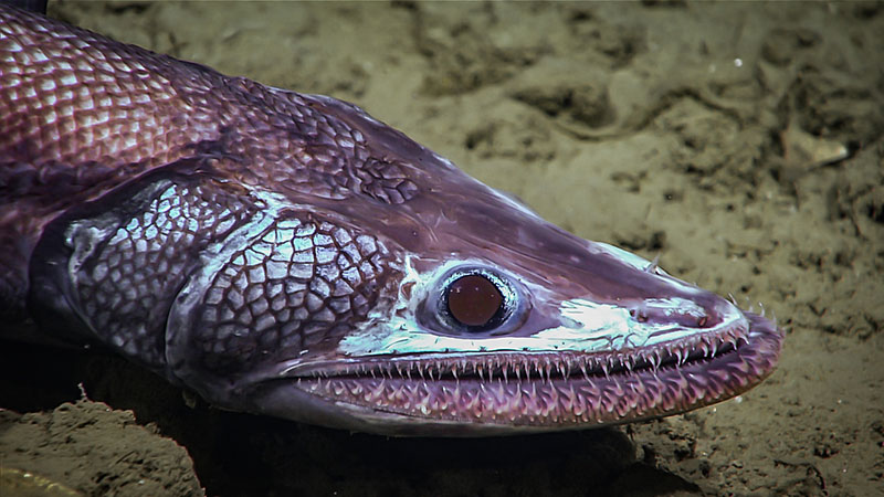
This deep-sea lizardfish was seen around 1,610 meters (5,282 feet) depth during the final dive of the Windows to the Deep 2019 expedition. Image courtesy of the NOAA Office of Ocean Exploration and Research, Windows to the Deep 2019. Download larger version (jpg, 1.3 MB).

Location of Dive 19 on July 11, 2019. Download larger version (jpg, 2.3 MB).
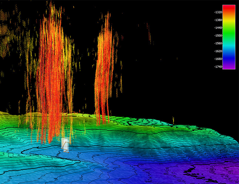
The remotely operated vehicle track for Dive 19, shown as an orange line with a white curtain. Scale is water depth in meters. The bright colors emanating up from the seafloor are the reflections from the bubbles in the water column being released from the seep sources. Download larger version (jpg, 5.3 MB).