By Margot Bohan - NOAA Office of Ocean Exploration and Research

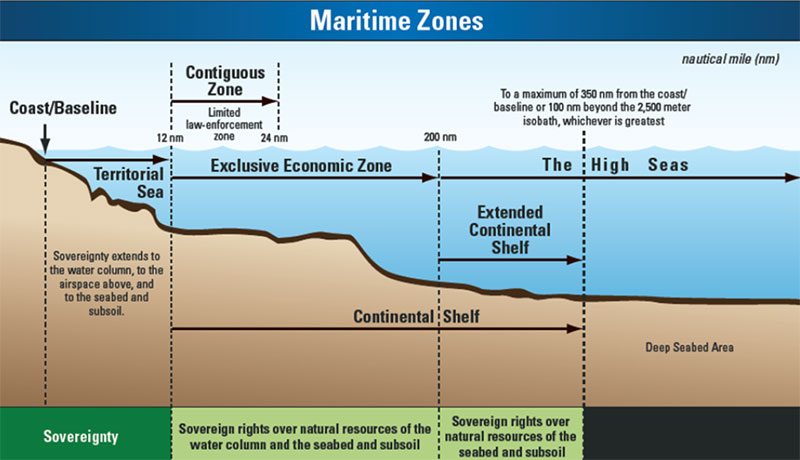
Under the United Nations Convention on the Law of the Sea (UNCLOS), the continental shelf is that part of the seabed over which a coastal State exercises sovereign rights with regard to the exploration and exploitation of natural resources, including oil and gas deposits, as well as other minerals and biological resources of the seabed. The legal continental shelf extends out to a distance of 200 nautical miles from its coast, or further if the shelf naturally extends beyond that limit. Image courtesy of the NOAA Office of Ocean Exploration and Research. Download larger version (jpg, 288 KB).
The NOAA Office of Ocean Exploration and Research is a critical partner in the U.S. Extended Continental Shelf (ECS) Project. The project is a multi-agency effort focused on helping the United States identify the extent of continental shelf seabed and sub-seafloor over which it can exercise sovereign rights beyond the nation’s 200 nautical mile Exclusive Economic Zone, consistent with the Law of the Sea Treaty . The U.S. ECS is predicted to be an important maritime zone, possessing many resources and vital habitats for marine life.
The project is thought to be the largest and potentially most significant cross-agency marine mapping effort ever undertaken by the United States. Since 2007, NOAA and a consortium of 13 other U.S. agencies have been collaborating to gather and analyze field survey data, legal data, and seafloor samples to determine the United States' shelf outer limits. To date, the project has involved 36 surveys and over 900 days at sea. Over 3.3 million square kilometers (967,810 square nautical miles) of bathymetric data (practically equivalent to a land area the size of Alaska, California, Texas, Montana, and Kentucky combined) and over 27,000 linear kilometers of seismic data (comparable to the distance from New York City to the South Pole) have been collected.

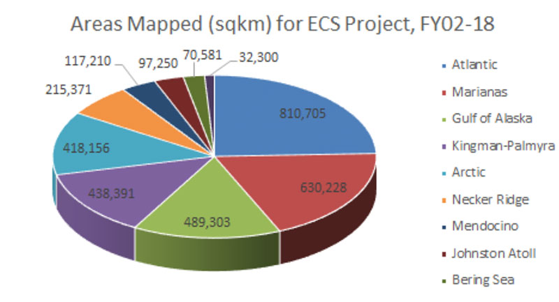
Areas mapped, in square kilometers, for the U.S. Extended Continental Shelf Project, from fiscal years 2002 to 2018. Image courtesy of the NOAA Office of Ocean Exploration and Research. Download larger version (jpg, 201 KB).
All project-relevant data and products are stored in an open-access archive at NOAA’s National Centers for Environmental Information. The archived data are yielding new seafloor maps that display, in high resolution, previously unknown deep-sea features such as guyots, submarine volcanic fields, interacting fans, seafloor channels, levees, and landslide scarps. ECS field surveys, as a general rule, are expanding our grasp of the morphology and geology along our continental margins in the deep-sea frontier and providing a rich baseline for setting future exploration, research, and resource management priorities.
Through the pursuit of additional detailed investigations of the ocean floor and water column, employing modelling processes and innovative technologies and the sharing of data via the information management system generated for this project, the U.S. ECS project represents the first step to answering some of NOAA and the nation’s key marine science and observation questions in these poorly known, yet likely resource-rich realms.

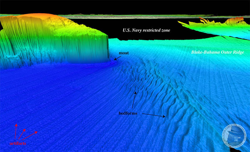
Perspective view of the bathymetry of Blake Spur. Blake-Bahama Outer Ridge (BBOR) in upper right background. Bedforms occur on a plateau built to the southwest of BBOR. Image courtesy of Center for Coastal and Ocean Mapping, Joint Hydrographic Center. Download larger version (jpg, 278 KB).
In the face of worldwide industrialization, legitimate concerns exist regarding the state and durability of the marine environment, including frontier areas being characterized for the first time through the ECS project. An increased understanding of this maritime zone, where the U.S. has potential for ECS, will enhance the breadth and effectiveness of our stewardship and may ultimately fuel economic prosperity and influence the strength of our nation’s security.
While the strain on deep-ocean resources is still considered modest, a window of opportunity exists to capitalize on our ECS investment and acquire the environmental intelligence and the means necessary to strike a balance between exploitation and preservation of this ocean realm.