By Bob Stern - University of Texas at Dallas
April 28, 2016

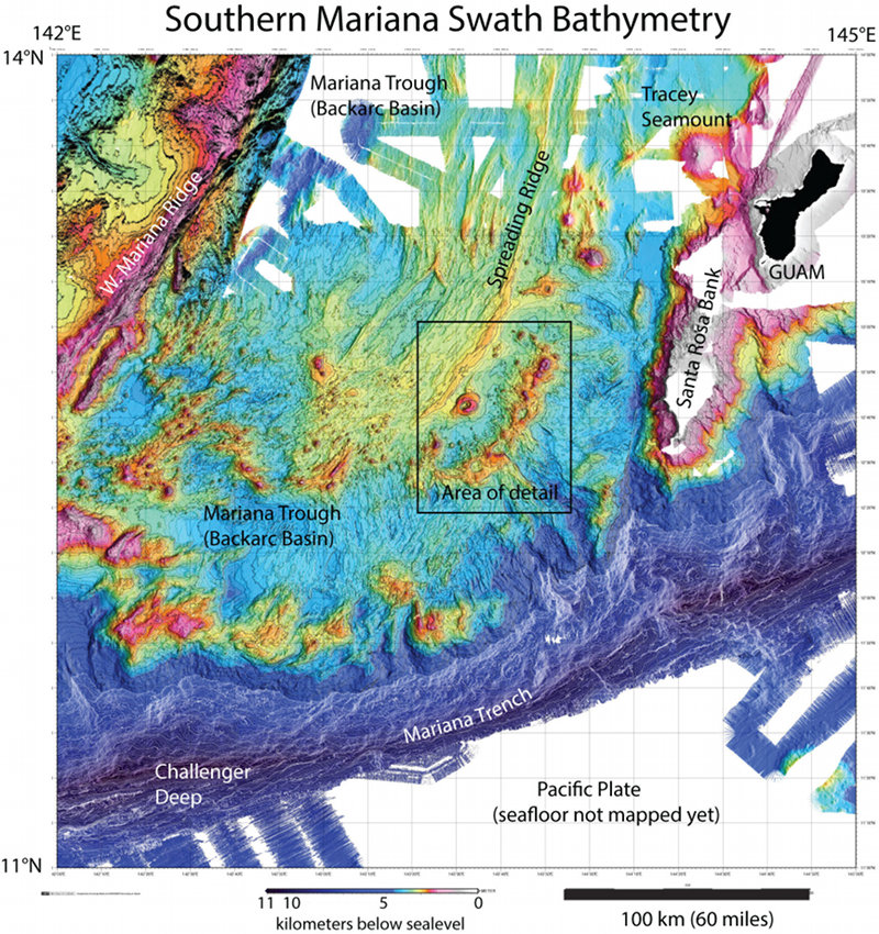
Figure 1: Bathymetry of the southern Mariana region. Colors show water depths: dark blue is deepest, reds are shallowest, black is land, and white shows areas that have not been mapped yet. This map required data from many cruises to compile (compilation thanks to Susan Merle, NOAA Pacific Marine Environmental Laboratory, Newport, Oregon). Box shows area of detail shown in Fig. 2. Image courtesy of the NOAA Office of Ocean Exploration and Research, 2016 Deepwater Exploration of the Marianas. Download larger version (jpg, 2.3 MB).
The science team explored three calderas in the small, enigmatic Fina Nagu volcanic complex in the southern Mariana Trough. The southernmost Marianas are geologically complex (Figure 1) and we are only just beginning to understand that complexity. The region is bounded to the south by the Mariana Trench (including the deepest place on Earth, the Challenger Deep), where the Pacific plate descends deep into the Earth below the Mariana-Philippine Sea plate (for more information on subduction, see this video ).
This is a fascinating region for geologists. The Mariana Trench marks the convergent plate boundary between the subducting Pacific plate and the overlying Mariana-Philippine Sea plate. The southern Mariana region is part of the over-riding plate and has high tectonic activity, such as faulting and earthquakes, as well as volcanism. Magma is generated above the subducting plate, and large “arc” volcanoes are found along the arc from the northern Marianas all the way to Japan. The strong tectonic activity in the southernmost Marianas is due to seafloor spreading on the overriding plate, which forms the backarc basin known as the Mariana Trough.

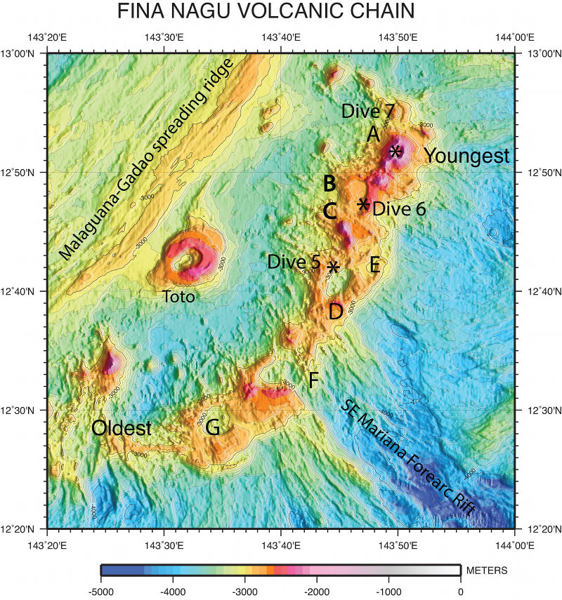
Figure 2: The Fina Nagu Volcanic Complex. Volcanic calderas A through G are shown. Note the flanking regions of strong faulting to the southeast (Southeast Mariana Forearc Rift) and regions of abundant seafloor volcanism (Malaguana- Gadao spreading ridge and Toto volcano) to the northwest. Also shown are locations of Okeanos Explorer remotely operated vehicle Dives 5, 6, and 7 (asterisks). Fina Nagu volcanoes and calderas are oldest in the southwest and youngest in the northeast. Image courtesy of the NOAA Office of Ocean Exploration and Research, 2016 Deepwater Exploration of the Marianas. Download larger version (jpg, 1.7 MB).
The Fina Nagu volcanic complex lies in this region of strong tectonic and volcanic activity (Fina Nagu means “beginnings” in the Chamorro language). It is flanked to the southeast by a region of intense faulting along the northwest-southeast trending Southeast Mariana Forearc Rift, and to the northwest by a region of active volcanism concentrated at Toto Caldera and along the backarc basin spreading axis, the Malaguana-Gadao Ridge (Figure 2).
The Fina Nagu Volcanic Complex, composed of seven calderas, trends northeast-southwest for ~65 kilometers (40 miles). Scientists were working under the assumption that the calderas to the southwest were older than those to the northeast, but until these dives, no one has seen the seafloor of any of the calderas. Calderas form when the central edifices of active volcanoes deflate, leading to a roughly circular collapse feature; a good example can be seen at Crater Lake National Park in Oregon.

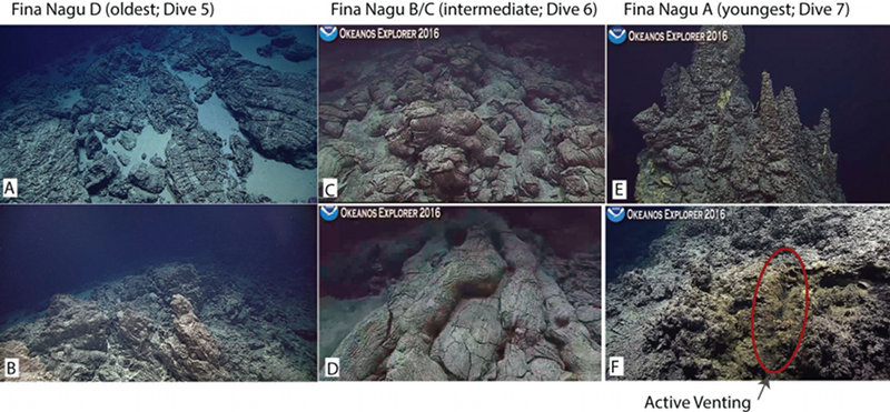
Figure 3: Screenshots of the seafloor observed during remotely operated vehicle dives on Fina Nagu: Dive 5 (3A, B), Dive 6 (3C, D), and Dive 7 (3E, F). The northern caldera wall of Caldera D consisted of fractured pillow lavas with some loose white sediment (3A) and dikes (3B). The eastern ridge separating Calderas B and C consisted of well-preserved pillow lavas (3C), some of which formed large tubes along the slopes (3D). We explored two small domes on the seafloor of Caldera A. The eastern dome was topped with a majestic fragile hydrothermal chimney complex that is 14 meters tall; only a few of the upper spires are shown in 3E. The western dome was covered with collapsed hydrothermal chimneys and deposits, and we also found a site of weak venting (3F). Image courtesy of the NOAA Office of Ocean Exploration and Research, 2016 Deepwater Exploration of the Marianas. Download larger version (jpg, 893 KB).
Results from our three dives support the idea of age progression along the Fina Nagu Complex. Seafloor exposures observed during Dive 5 on the north wall of Caldera D are the most degraded, with fractured and broken-up pillow lavas and dikes (Figures 3A, B).
Seafloor exposures on the ridge between Calderas B and C observed during Dive 6 preserve beautiful, fresh pillow lavas (Figures 3C, D).
On Dive 7, we explored two small domes inside Fina Nagu A caldera and discovered a fantastic extinct hydrothermal chimney complex that the remotely operated vehicle pilots estimated to be 14 meters tall! A part of this majestic structure is shown in Figure 3E. We saw incredibly delicate and well-preserved chimneys, ledges, and flanges. Because it is still standing, it is probably only recently inactive; otherwise it would have collapsed from the frequent earthquakes in this tectonically active region. We also found small patches of diffuse flow that are indicative of current (although weak) hydrothermal activity (Figure 3F).
These three dives were a lot of fun and intellectually rewarding. The biologists also found lots of interesting critters, but there’s no space here to share those now. You’ll have to keep following the expedition!