By Kelley Elliott, NOAA Office of Ocean Exploration and Research
Kasey Cantwell, Expedition Coordinator, NOAA Office of Ocean Exploration and Research
April 20 – July 10, 2016

This Google Earth map shows the operating area of the 2016 Deepwater Exploration of the Marianas expedition. Leg 1 of the expedition will focus on the southern half of the CNMI and MTMNM, and Legs 2 and 3 will focus on the northern half. The white line shows the U.S. Exclusive Economic Zone, the red polygons are the boundaries of the Trench and Islands Unit of the MTMNM, and the red triangles are the Vents Unit of MTMNM. The green contour lines are the 250-meter contours surrounding Guam and the CNMI, and light blue are 6,000-meter contours marking the shallow and deep end of the depth range for operations. The white balloons show the location of planned ROV dives during Leg 1 of the expedition, and the pink balloons are some of the dives planned for Leg 3 (more sites will be identified based on mapping data acquired during Leg 2). The yellow boxes are areas where mapping data has been requested by scientists and managers. Image courtesy of the NOAA Office of Ocean Exploration and Research, 2016 Deepwater Exploration of the Marianas. Download larger version (jpg, 2.2 MB).
From April 20 to July 10, 2016, NOAA and partners will conduct a three-cruise expedition on NOAA Ship Okeanos Explorer to collect critical baseline information of unknown and poorly known areas in and around the Marianas Trench Marine National Monument (MTMNM) and the Commonwealth of the Northern Mariana Islands (CNMI). The primary expedition goal is to acquire baseline information in deepwater areas to support science and management needs, and to understand the diversity and distribution of deepwater habitats in and around the CNMI and MTMNM.
In the coming months, we expect to explore bottomfish habitats, new hydrothermal vent sites, mud volcanoes, deep-sea coral and sponge communities, and seamounts, as well as subduction zone and trench areas. The geology of the Mariana region is incredibly complex and dynamic. Despite decades of previous work in the region, much of the Monument and surrounding areas remain unexplored.
The three-leg 2016 Deepwater Exploration of the Marianas expedition will help us identify and better understand new geological phenomena and habitats – such as extreme life living in the deepest oceanic trench on the planet, enormous mud volcanoes, active hydrothermal vents, chemosynthetic communities, and possibly deep-sea coral and sponge habitats – for which the Marianas Trench Marine National Monument was designated.
Baseline data from this expedition will help improve our understanding of the deep-ocean habitats of the Mariana archipelago, and the connections between communities at different seamounts and hydrothermal vent sites. Data collected will also provide critical information for the development of management plans for Monument areas; support local scientists and managers seeking to understand and manage precious corals and bottom fish resources; and provide a foundation of information to stimulate follow-on exploration, research and management activities.

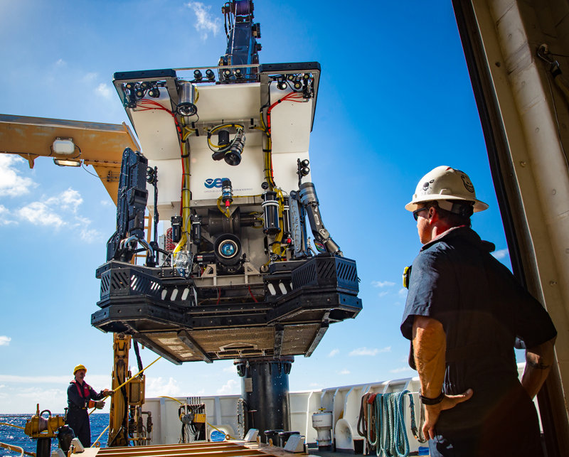
ROV Deep Discoverer (D2) will be used to conduct daily dives from 250 to 6,000 meters on Legs 1 and 3 of the 2016 Deepwater Exploration of the Marianas expedition. Dives will survey seafloor habitats and include high-resolution visual surveys and limited sampling. Here, the Chief Bosun watches as ROV D2 is deployed from the aft deck of NOAA Ship Okeanos Explorer. D2’s powerful lighting, high-definition camera, and sample collection equipment (drawers, boxes, an advanced manipulator, and positionable illumination system) are visible. Image courtesy of the NOAA Office of Ocean Exploration and Research. Download larger version (jpg, 9.2 MB).
The 2016 Deepwater Exploration of the Marianas expedition will address science themes and priority areas put forward by scientists and managers from NOAA, local CNMI management agencies, and the broad ocean science community. Operations are being planned to complement previous and planned field work in the area, including by the NOAA Pacific Marine Environmental Laboratory’s Earth-Ocean Interactions Program, the U.S. Extended Continental Shelf Project, Schmidt Ocean Institute’s R/V Falkor expeditions , and the Japanese Agency for Marine Earth-Science and Technology .
Expedition priorities include a combination of science, education, outreach, and open data objectives that will support management decisions at multiple levels:
Operations will use the ship’s deepwater mapping systems (Kongsberg EM302 multibeam sonar, EK60 split-beam fisheries sonars, Knudsen 3260 chirp sub-bottom profiler sonar and Teledyne Acoustic Doppler Current Profilers); NOAA’s two-body 6,000-meter remotely operated vehicle (ROV) system; CTD rosette; and a high-bandwidth satellite connection for real-time ship to shore communications. ROV dives will be conducted from 250 to 6,000 meters and will include high-resolution visual surveys and limited specimen collection.
The 69-day expedition is divided into three cruise ‘legs’ – one around-the-clock mapping cruise, and two combined ROV/CTD/mapping legs. The tentative schedule for the full expedition is:
The ship crossed the international date line during the transit to the Marianas, so the dates for ROV operations in the mainland U.S. are daily from April 20 through May 9 and June 17 through July 8.
This expedition is part of the three-year Campaign to Address the Pacific monument Science, Technology, and Ocean NEeds (CAPSTONE), an effort to explore high-priority unknown areas in the Pacific marine national monuments. The central and western Pacific marine national monuments and national marine sanctuaries encompass over 742,000 square miles of emergent land, coral reef, ocean, and maritime heritage resources as well as harbor numerous protected species and likely an abundance of undiscovered resources. CAPSTONE provides timely, actionable information to support science-based decision making regarding some of these last relatively pristine marine ecosystems on the planet.

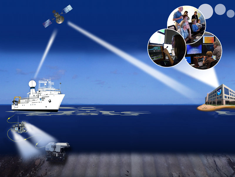
NOAA Ship Okeanos Explorer uses telepresence technology to transmit data in real time to a shore-based hub where the video is then transmitted to a number of Exploration Command Centers located around the country as well as to any Internet-enabled device. Access to the video combined with a suite of Internet-based collaboration tools allow scientists on shore to join the operation in real-time, and allows the general public to follow the expedition online. Image courtesy of the NOAA Office of Ocean Exploration and Research. Download larger version (jpg, 1.1 MB).
The United States’ first and only federal vessel dedicated to exploration of our largely unknown ocean, NOAA Ship Okeanos Explorer, conducts operations in a globally unique way, using telepresence to engage the majority of the science team from shore. Via telepresence, real-time video and other oceanographic data are transmitted through satellite and high-speed Internet pathways to scientists around the country.
Scientists access the live feed by standing watches in Exploration Command Centers (ECCs), tuning in to the high-definition video via Internet 2, or watching the live video on standard Internet from their home institutions. Shore-based scientists interact with the ship through a teleconference line and Internet collaboration tools. Using these communication tools, the scientists and students can contribute expertise and help guide the at-sea operations in real time, extending the reach of ocean exploration to more scientists and students than could possibly be accommodated onboard.
A number of ECCs will be online for the expedition, including several ECCs and viewing centers joining Okeanos Explorer operations for the first time. Formal ECCs include: the University of Hawaii at Manoa; NOAA's Inuoye Regional Center in Hawaii; NOAA Headquarters in Maryland; Harbor Branch Oceanographic Institution in Florida; Inner Space Center at the University of Rhode Island; Stennis Space Center in Mississippi; University of New Hampshire; and Pacific Marine Environmental Laboratory in Washington and Oregon. In the Marianas, the University of Guam is setting up an Internet 1-based ECC/viewing center, and UnderwaterWorld Guam will be sharing the feeds with the public from a “mock command center” exhibit at their aquarium.
Scientists are also expected to participate from a number of other remote locations, including Woods Hole, Massachusetts; Albany and New York, New York; Lafayette, Louisiana; Galloway, New Jersey; Kearneysville, West Virginia; Moscow, Idaho; Tallahassee and Gainesville, Florida; College Station and Dallas, Texas; La Jolla, Moss Landing, and San Diego, California; Washington, D.C.; Guam; Saipan; and from Japan, Canada, Australia, Russia, and the United Kingdom. These scientists, and others on call if a discovery is made at sea, will contribute their expertise in real time to operations at sea.
This expedition provides extensive opportunities for the public to connect to the mission. The live video feeds are available to anyone online, providing the public with a front row seat to exploration activities and discoveries as they are made.
Web content developed for this expedition include background content; mission logs; daily updates; videos and images; and a live video feed. Educators and students can engage their classrooms through the Expedition Educational Module, which provides access to products tied to the expedition, including standards-based lesson plans, background information, ocean career connections, links to previous Office of Ocean Exploration and Research-sponsored expeditions, and more.