
By Bill Chadwick - Oregon State University and NOAA/PMEL
Patty Fryer - University of Hawaii
There are so many exciting geological features within the Mariana region, the area is like an amusement park for geologists. The region has earthquakes, volcanoes, hydrothermal vents, cold seeps, and the biggest mud volcanoes on Earth. There are many extremes within this region: it hosts the deepest place on the planet (at the Challenger Deep in the Mariana Trench at 10,916 meters or 35,814 feet deep), extraordinary activity in the volcanic arc including submarine eruptions, venting of liquid carbon dioxide, ponds of molten sulfur, and hydrothermal vents that are teeming with exotic species. Between the Mariana Trench and the island volcanoes, huge mud volcanoes provide a window into the boundary between two tectonic plates that have been colliding for over 50 million years and harbor unique communities of organisms that thrive in the most extreme fluid composition recorded in the oceans. For all these reasons, the area has been designated as a National Monument, the Mariana Trench Marine National Monument.
Why is there so much geological activity in this corner of the world? It’s because tectonic plates are colliding in some areas and spreading apart in others, producing a wide variety of environments that make the Mariana region such a fascinating place to explore.
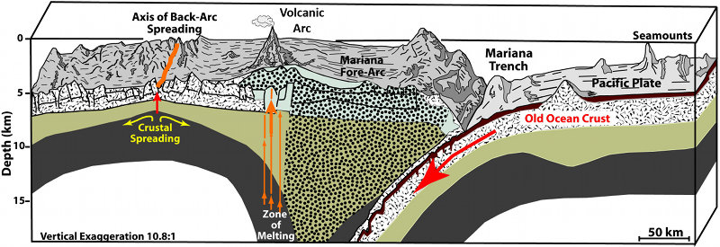
Figure 1: Cross-section of the Mariana subduction zone, showing the relationship between the Trench, Forearc, Volcanic Arc, and Back-Arc. Image adapted from Hussong and Fryer, 1981. Download larger version (jpg, 380 KB).
Where tectonic plates collide they form trenches, which are the deepest places in the world’s ocean. At a trench, one tectonic plate (the “downgoing plate”) plunges beneath another (the “overriding plate”) at what is called a “subduction zone.” The downgoing plate bends and angles downward into the Earth’s mantle, and the boundary between the two plates develops into a trench (Figure 1).
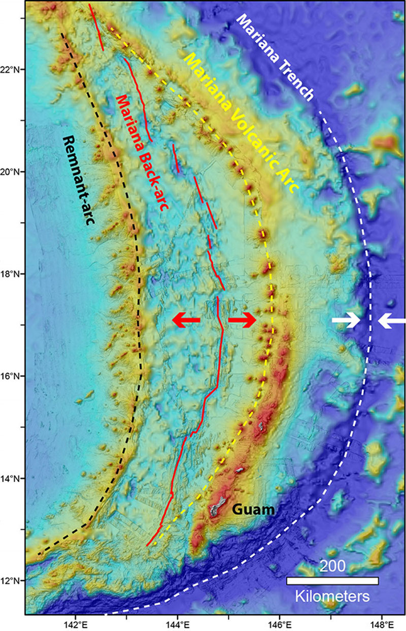
Figure 2: Map showing the locations of the Mariana Trench (white dashed line), Volcanic Arc (yellow dashed line), and back-arc spreading center (red line) and remnant arc (black dashed line). Image courtesy of Bill Chadwick. Download image (jpg, 279 KB).
At the Mariana Trench, the downgoing plate is called the Pacific Plate, and the overriding plate is the Philippine Sea Plate. The depth of the Mariana trench varies along its length. Where large, old seamounts are present on the Pacific Plate at the subduction zone, the trench is shallower. Such collisions involving subducting seamounts also cause the edge of the overriding Philippine Sea Plate to uplift.
In the Mariana system, the trench is curved in map view (see the white dashed line on Figure 2). The actual forces that control the shape of the trench are related to broad regional plate movement. Over its history, as the Pacific Plate has been subducted, it has been “rolling back” toward the east. That means the trench has migrated eastward with time. The Mariana Trench, however, is “pinned” on both its north and south ends by the jamming up of subduction through collision with the Ogasawara Plateau in the north and the Caroline Ridge in the south. This is why the Mariana system and its youngest back-arc ocean basin is “banana shaped,“ concave to the west.
The forearc is the “museum” of the Marianas. This region, between the trench and the volcanic arc (Figure 3), preserves the earliest evidence of subduction and the entire history of the three episodes in which the island arc system was torn apart, with the trench and volcanic arc moving eastward and leaving new back-arc ocean basins in its wake, as the Pacific Plate has rolled back. All this tectonic activity left the forearc heavily deformed, thus faults crisscross most of it.
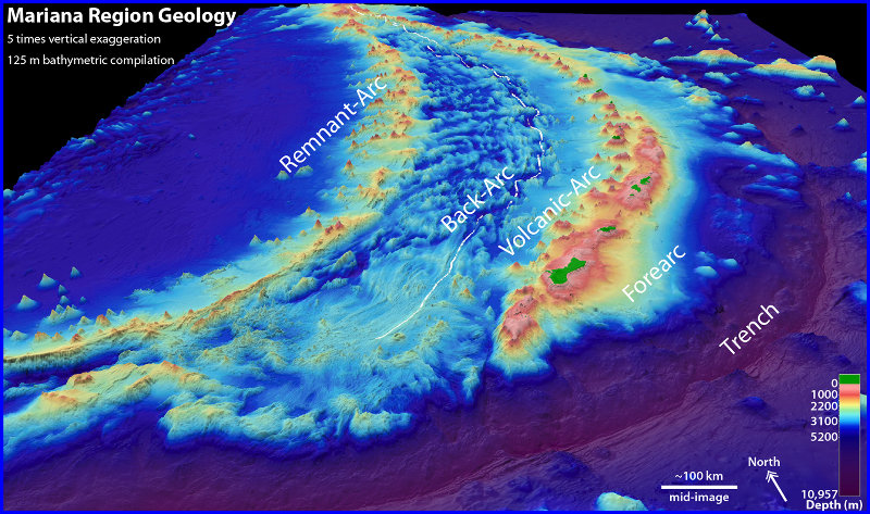
Figure 3: Oblique 3D-view of the Mariana region with the seafloor colored according to depth (purple = deepest; red = shallowest; green = islands). Labels show locations of Trench, Forearc, Volcanic Arc, and Back-arc. Image courtesy of Susan Merle. Download larger version (jpg, 1.2 MB).
The active subduction process continues to affect and update the museum. A downgoing tectonic plate can remain stuck under a forearc region for months or years or decades, as the subduction zone between them builds up collision energy. When the stress gets too big, the plates slip along the contact fault between them and an earthquake occurs. Such earthquakes (like the Japan earthquake of 2011) can cause devastation and dangerous tsunamis. Big earthquakes cause smaller aftershocks, and the movement on preexisting forearc faults pulverizes rock along the fault contacts. Some of these faults apparently cut right through the entire forearc crust and mantle, reaching depths of up to 18 kilometers (nearly 11 miles).
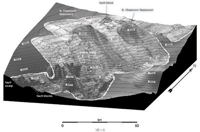
Figure 4: Oblique view of survey of two serpentine mud volcanoes on the southern Mariana forearc. View is from the southeast of sonar backscatter (dark = rough seafloor, light = smooth sedimented seafloor) superimposed on bathymetry data. Contour interval is 500 meters, annotated every 1,000 meters. Vertical exaggeration = 5 times. Image shows North and South Chamorro Seamounts, debris flows from a sector collapse of South Chamorro Seamount and fault scarps near the trench, which is toward the lower right corner of the image. Image courtesy of Fryer et al. 1999. Download image (jpg, 68 KB).
At such depths, the downgoing Pacific Plate has begun to release fluids as temperatures and pressures increase (essentially a geologic “distillation” process). The fluids rise along the deep faults, reacting with pulverized forearc mantle to “hydrate” the mantle minerals (olivine and pyroxene) and form the mineral serpentine. The resulting serpentinite/fluid mud is less dense than the surrounding rock, so it rises to the seafloor in the forearc, erupting to form mud volcanoes as big as 50 kilometers (30 miles) in diameter and 2,000 meters (6,562 feet) high (Figure 4).
Pieces of the downgoing Pacific Plate are also brought up in the muds. These come from the contact zone between the plates, so studying these materials can tell us about the conditions where the earthquakes happen. Fluid seeps at these mud volcanoes form ghostly chimney structures. These seeps have extreme chemical compositions, yet they support unique seafloor and sub-seafloor biological communities (Figure 5).
Closer to the active volcanic arc are the larger Mariana Islands of Guam, Rota, Tinian, and Saipan. They are all uplifted portions of the Mariana forearc, mostly marine reefs, sediments, and old volcanic deposits that have bobbed up as the surrounding seafloor has slipped away from them along faults unloading the edges of the islands with the weight of that material. Geologists call this “footwall uplift.”
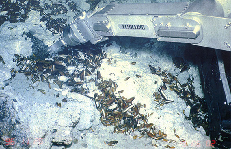
Figure 5: Seafloor photo of the summit area of South Chamorro Seamount showing the Shilling manipulator arm of the JAMSTEC Shinkai 6500 submersible reaching to sample mussels at a seep site. Also in the frame are gastropods, tubeworms, and a crab. Image courtesy of JAMSTEC Shinkai 6500 submersible. Download larger version (jpg, 3.9 MB).
As the downgoing plate plunges even deeper into the Earth’s mantle, fluids that continue to be released cause melting in the surrounding hot mantle at depths from 70 to 100 kilometers (42 to 60 miles). This generates magma (molten rock) that rises up toward the surface and feeds a chain of volcanoes about 200 kilometers (124 miles) west of and parallel to the trench (see yellow dashed line on Figure 2). This chain is called a volcanic arc.
The active volcanoes of the Mariana Arc are mostly seamounts (underwater volcanoes), with summits that are only a few hundred meters (< 1,000 feet) below the ocean’s surface, and only nine are tall enough to form islands. Many are spaced out along a chain with the largest volcano situated farthest east. These make up what is called the volcanic “front.”
Most of the frontal volcanoes also have a chain of additional volcanoes that lie on a line to the west. What is interesting about these “cross-chain” volcanoes is that all of them can be active at the same time. Apparently, arc magma can leak into the backarc region from the arc magma source.
Hydrothermal vents at the summits of the arc volcanoes have a wide variety of ecosystems and a complex and extremely variable (both in space and time) structure and chemical composition.
In some subduction zones like the Mariana system, where strong rollback forces are at work, the overriding plate is under tension. The volcanic arc is the weakest point because it is both warmer and more “brittle,” so that is where the arc typically starts to break up. Each time the Mariana Volcanic Arc has broken up, the crust and upper mantle faulted, stretched thinner, and began to subside. At this point, an ocean basin started to form between the still-active volcanic front on the east and what eventually became an inactive remnant arc on the west (see black dashed line on Figure 2).
During this first stage of break-up, scattered volcanism can occur on the newly-forming ocean basin floor, but after a few million years, the volcanism becomes more organized into a series of seafloor spreading center segments (see red lines on Figure 2).
Volcanism on these segments creates new ocean crust with a different composition from the volcanic arc. Because of the concentrated volcanic activity along the back-arc spreading segments, hydrothermal vents tend to focus along them. Unlike the shallow hydrothermal systems on the arc and cross-chain volcanoes, the vent sites on the back-arc spreading center segments are deeper (3,000-5,000 meters or 10,000-16,000 feet) and have different geologic and chemical environments and very different vent ecosystems.
Among the places that Okeanos Explorer will be visiting in the Mariana region this year are older seamounts on the Pacific Plate, possible recent volcanism on the Pacific Plate near the trench, forearc scarps that expose the Earth’s mantle, serpentine mud volcanoes with their communities of seep organisms and chimney structures, hydrothermal vent sites in the volcanic arc and back-arc including a recent eruption site that was just discovered in December 2015, older caldera volcanoes in the southern volcanic arc, and shallow banks that are part of the arc and important for fisheries habitat.