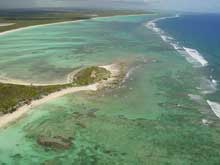
Breezy Point, East Caicos, is mentioned in the archival documents about the wrecking of Trouvadore. The offshore fringing reef is the location of several shipwrecks. Click image for larger view and image credit.
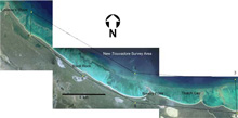
The 2006 Survey area on the north coast of East Caicos, BWI.
The Search for Trouvadore: Mission Statement
July 8 – July 22, 2006
Donald H. Keith, Ph.D.
Toni L. Carrell, Ph.D.
Ships of Discovery
Archaeology
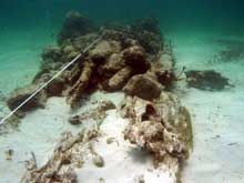
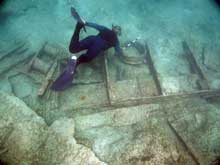
During a helicopter reconnaissance trip to East Caicos, Turks & Caicos Islands, in February 2003, at least three shipwrecks were seen on the reef. During a 2004 survey, one massive debris field of an iron-hulled ship, several anchors and chain, ballast stones, an iron mast, a small wooden ship, and a modern wooden yacht were found. How can we identify any of these as Trouvadore’s remains? What specific artifacts might we expect to find?
In 1841, "wrecking" was a well-established practice in the islands, and extensive salvage was undertaken by local salvors. Recovered items included sails, rigging, chain cables, and personal effects. What might remain today are items of little value at the time, but they might help identify a wreck as a slave ship.
The construction of the ship itself will provide important clues. At this stage we know very little about Trouvadore other than that it was described as a brigantine and that it set sail from the coast of Africa with more than 200 slaves and a crew of about 20. A typical 19th-century brigantine was a two-masted, square-rigged ship with a gaff sail aft of the main mast and stay sails on both the main and fore masts. In order to carry a cargo of 200 or more slaves, Trouvadore was approximately 30 m long with a 10 m beam, a typical mid-sized ship of the day. Hull remains alone, however, will not be the best identifier. Brigantines and schooners were both used in the slave trade; the main difference between them was their rig, not their hulls. To further confuse things, only a slight difference in rigging could turn a schooner into a brigantine, so other artifacts associated with the ship will be of more help in its identification.
A list of “paraphernalia” derived from the “equipment clause” in the Anglo-Dutch anti-slavery treaty of 1822 may prove the most useful in identification of the wreck. The presence of the items in the equipment clause–even when slaves were absent–was considered sufficient evidence of a vessel’s involvement in the slave trade. As such it was subject to capture and condemnation. This equipment included extra bulkheads and spare lumber, iron manacles and chains, oversized iron cooking cauldrons and mess tubs, large quantities of victuals, extra water casks, grated instead of closed hatch covers, and an overabundance of firearms and otherweapons.
Absent the preservation of these items, the best clues to the identity of Trouvadore will be glass and pottery. The ship sailed from Spanish ports with a Spanish crew, later replaced with Portuguese sailors when their numbers were drastically reduced by illness and death. The ship’s destination was the Spanish colony of Cuba. The belongings of the crew and the containers that held the ship’s stores should reflect their origin and ports of call.
Survey Area
Several archival documents refer to Breezy Point and/or East Caicos as the wreck location of Trouvadore. It is assumed this is a reference to modern day Breezy Point, a prominence on the north shore of East Caicos that extends out almost to the reef fringing the north coast of the island.
There is a prominence approximately 2.5 km East of Breezy Point called Thatch Cay, and another about 2.5km to the West called Black Rock. It is also reasonable to assume that if Trouvadore had wrecked closer to one of these points, those locations would have been mentioned instead of Breezy Point. This narrows the search for Trouvadore’s remains to the area between the reef and the shore around Breezy Point.
The search area is approximately 5.5 kilometers long by 800 meters wide. The water depth in the lagoon is a maximum of 23 feet (7 m). Scattered large coral heads dot the lagoon and finger reefs extend shoreward from the fringing reef. Outside the fringing reef, which is often visible at low tide, the water depth slowly drops off to 60 feet (20 m) before plunging several thousand meters. The maximum water depth in the search area outside the reef is approximately 30 ft (9 m).
Search Technology
During our 2004 survey an innovative high-low tech approach proved extremely effective, and will be employed again this season. The control of the paths of the search boats and the locations of wreck sites and debris fields was accomplished with hand-held, data-logging GPS receivers in conjunction with highly detailed, digital, “geo-referenced” aerial images of the north coast of East Caicos. Geo-referencing is a technique that imposes map grid coordinates on an aerial image so that it can be used like a map: all measurements and directions taken from the image are true and tied into standard mapping conventions. We used the Universal Transverse Mercator (UTM) grid convention, which facilitated distance calculations.
During our 2006 survey, the team will use a combination of high and low technology to locate ships and debris fields in the underwater search area. The high tech approach will employ a remote-sensing package consisting of a magnetometer and Differential Global Positioning System (DGPS) to survey the area outside the fringing reef.
A magnetometer is a passive device that can detect concentrations of ferrous material, such as iron anchors, cannon, or ships’ fittings, all of which produce a variation, or anomaly, in the earth’s magnetic field. This makes magnetometers a highly useful tool for shipwreck searches and studies.However, a magnetometer must be towed relatively close to the object to detect it. For example, a site with iron ballast and fittings can be detected at 80 to 100 meters, an isolated anchor at 30 meters. Generally, shallow-water surveys are done at close lane spacing, on the order of 30 to 50 feet.
The magnetometer is integrated with a highly accurate DGPS providing sub-meter accuracy for the location of any target or anomaly. Specialized navigation software will allow the survey team to design and delineate survey areas, process and edit the data, and generate final products such as contour maps and plotting sheets.
On the reef top and in some areas in the lagoon the shallow water and numerous reef outcrops make deployment of towed equipment problematic. In those areas a low-tech approach is most appropriate. This will be accomplished using mostly towed divers but will also include the use of diver propulsion vehicles (DPVs), which will facilitate speedy coverage of large areas.
In both situations, as sites are identified they will be buoyed and divers will be dispatched to begin the documentation process (photography, mapping, and limited sampling as appropriate). Divers will also use underwater metal detectors as an aid in determining site limits. All sites and finds will be entered in the Turks & Caicos National Museum’s archaeological database, adding to the nations growing inventory of underwater cultural heritage.


