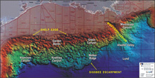
This is a computer-enhanced multibeam bathymetry map of the northwestern and northern Gulf of Mexico continental shelf and slope. The continental slope surface reflects an array of intraslope basins, sites of thick accumulations of sediment, surrounded by higher relief features in the form of ridges and domes that are the expressions of salt masses in the shallow subsurface. Major lease areas established by the Minerals Management Service are superimposed on the image and important features, like the Sigsbee Escarpment at the base of the slope, are labeled. Click image for larger view and image credit.
A Complex Geologic Framework Prone to Fluid and Gas Leakage: Northern Gulf of Mexico Continental Slope
Harry H. Roberts
Department of Oceanography and Coastal Sciences
Louisiana State University
The continental slope of the northern Gulf of Mexico is arguably the most geologically complex shelf-to-deep-basin transition in today’s oceans. This complexity comes from the dynamic interplay between vast quantities of river-transported sediment deposited over thick layers of salt formed during the early stages of the Gulf's evolution.
The Gulf was born as the North American and South American continents drifted apart, approximately 200 million years ago. During the initial phases of rifting (cracking or breaking apart), large volumes of salt were deposited during the mid-to-late Jurassic Period, between 175- and 145-million years ago. (We refer to this salt as the Louann salt.) At the same time, thick limestones were also deposited. The limestones represent deposits from ancient tidal flats, reefs, and other carbonate-producing environments. Today these rocks are the source beds for much of the oil and gas now produced in the Gulf.
During this early part of the Gulf’s evolution, very little river-borne sediment entered the Gulf basin. However, with the rise of the Rocky Mountains (starting about 150- to 100-million years ago), sediments that eroded from this new mountain range started arriving along the northwestern and northern rim of the Gulf. These sediments were deposited over the Louann salt. As more sediment arrived and deposits increased in thickness, the underlying salt was deformed and flowed like toothpaste squeezed from a tube. This slowly deforming salt layer changed into a variety of forms from domes to salt sheets. This process continues today. As sediments have been continually added to the northern and northwestern Gulf rim, salt has been squeezed seaward in front of a constantly thickening wedge of sediment. Today, the steep transition between the bottom of the continental slope and the deep Gulf floor, called the Sigsbee Escarpment, represents old Jurassic Louann salt being squeezed seaward over much younger sediments.
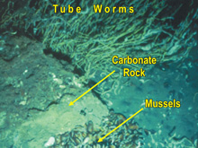
A chemosynthetic (able to form organic compounds from the energy from chemical reactions vs. sunlight) community of tube worms and mussels surrounds a large block of carbonate that (like the biological components) is a product of this hydrocarbon seep setting. This image was taken in the Green Canyon Lease Area, Block 232, at 570 m depth. Click image for larger view and image credit.
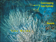
A chemosynthetic community of tube worms and mussels adjacent to exposures of outcropping gas hydrate. The picture was taken in the Mississippi Canyon Lease Area, Block 118, at 888 m depth. Click image for larger view and image credit.
The modern surface of the continental slope reflects this dynamic history of sediment deposition and the compensating salt deformation. The accompanying figure illustrates the extensive array of smooth bottom basins surrounded by domes and ridges that are supported by subsurface salt masses. The continued "squeezing" of salt causes numerous fractures and faults in surrounding sediments. These fractures then serve as pathways through which fluids and gases rise from the deep subsurface, where they have been produced. Since the Gulf of Mexico is a prolific oil and gas province, the fluids and gases reaching the continental slope surface are typically rich in hydrocarbons. Areas where hydrocarbons rise up from the subsurface are referred to as "hydrocarbon seeps." Hydrocarbon seeps and more productive vents provide the unique biochemical and geochemical environments necessary to sustain communities of unusual bottom-dwelling organisms.
The types of fluids and gases, as well as the volumes and rates of flow of these fluids up to the sea floor, also affect geologic response. When hydrocarbon fluids and gases are rapidly expelled at the sea floor, for example, mud volcanoes and mud flows often form. Bacterial mats and clam populations are typically found at these settings. In cases where hydrocarbons slowly seep to the seabed, microbes catalyze the precipitation of Ca-Mg carbonates, resulting in hardgrounds and mound-like carbonate buildups. In many areas, these carbonates are the hard substrates for deep-water coral communities and other communities requiring hardbottom conditions. Between these two extremes of rapid venting and slow seepage are environments that support dense and diverse chemosynthetic communities. Many sites of chemosynthetic mussel and tube worm communities occur where gas hydrate (a unique combination of frozen water and methane gas) is exposed at the surface or is present in the shallow subsurface. Gas hydrate appears to function as a resource used in long-term maintenance of chemosynthetic communities.
Most of our knowledge of the fluid and gas expulsion process and geologic/biologic responses on the modern sea floor in the Gulf of Mexico comes from study of the upper continental slope (to a water depth of 1,000 m). Research associated with this project is focused on developing a better understanding of the geology and biology of fluid and gas expulsion sites of the middle and lower continental slope to water depths of nearly 3,000 m. This deeper exploration is enabled by the use of the deep submergence vehicle Alvin, a submersible capable of working in waters as deep as 4,500 m.


