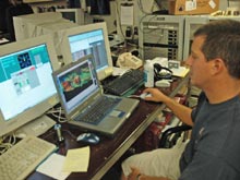
Sonar Data Systems Specialist, Akel Stirling, edits processed phase bathymetry data collected by the DSL120. He is one of three acoustic technicians with the Hawaii Mapping Research Group on board specifically to process sonar data. Click image for larger view and image credit.

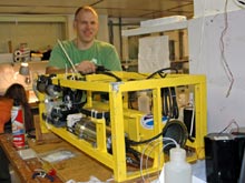
Chemical Oceanographer, Joe Resing, compiles data collected by this in situ chemical analyzer on board the DSL120 clump weight. Data collected from the analyzer is processed to determine iron and magnanese content, as well as changes in pH of the seawater the sensor flew through. Joe looks at all of the information and finds anomalies in the data sets that may indicate the presence of hydrothermal plumes. Click image for larger view and image credit.
Collaborative Discovery
January 5, 2006
Kelley Elliott
Web Coordinator
NOAA Office of Ocean Exploration
During this cruise, we have found many vent sites within several hours of Medea reaching the bottom- an impressive feat demonstrating the strength of the method used to choose Medea deployment sites. The final analysis of processed information and decision where to lower Medea is made by the Principal Investigators on board, representing 5 of the 36 members of the science team. The processed maps and information they work with, however, represent the efforts of many.
The science team arrived on board the RV Thompson with an initial, relatively low-resolution multibeam map revealing the Mid-Ocean Ridge. Higher resolution data sufficient to choose the spreading axis precisely and provide more information about the geomorphology of the region was gathered during the first week of the cruise and continues to be gathered by the EM300 multibeam system. As the EM300 multibeam sonar collects the data, the raw data flowing in is monitored, processed and edited by a team of 3 graduate students on board (Jason Meyer, Stacy Supak, and Melissa Eitzel), and the final processed data is turned into maps used for analysis by marine geophysicist Scott White.
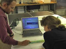
Rachel Haymon, Scott White, and Ken Macdonald use the higher resolution EM300 multibeam maps (with an average seafloor depth calculated for every 40m 2 area within the survey region) to choose the track lines for the DSL120 surveys. The chief scientist then passes the information along to the Pilot House and DSL team. The crew moves the ship into position, and the DSL team prepares the DSL120 tow-sled for deployment. The sled is finally deployed off the back deck with a crew of at least 15 people from the Thompson crew and the DSL team.
Once the DSL120 sled is flying above the seafloor collecting data, Akel Stirling, Jennie Morgan, and Jamie Smith from the Hawaii Mapping Research Group (HMRG) monitors, processes, and edits the incoming data. They create grayscale sidescan images of the seafloor, and color bathymetry images that are gridded (at a scale of 1.6m 2 ) and turned into maps for analysis. The sonar data collected gives the science team information about the seafloor terrain, reveals some structures, and shows where the ridge axis is likely to be, and therefore where most of the heat is likely to be concentrated. Sensors on board the tow sled measuring light scattering, methane, and changes in the redox (electrical) potential of the surrounding seawater send real-time data back to the ship where it is collected and interpreted by chemical oceanographer Joe Resing. Signals found in incoming data indicate the presence of vent plumes, and aid in the identification of places to deploy the Medea camera sled.
After days of surveying, the DSL120 is brought back on board. Sensors and Miniature Autonomous Plume Recorders (MAPRs) that had been attached to the DSL120 sled, clump weight, and cable above and below the clump weight are taken off and brought into the main lab for data extraction. Oceanographer Sharon Walker extracts the pressure, temperature, and light-scattering sensor data collected by the MAPRs and edits the data to account factors besides vent plumes encountered during data collection. The data is processed and analyzed to create a number of graphs and figures showing where vent plumes may be located. In addition, a chemical analyzer on board the clump weight gathers data to determine iron and maganese content, as well as changes in the acidity of the seawater as the DSL120 was towed. The plume team looks at all of the information and finds plume signals in the data sets, then identifies geographic locations where the sensors likely flew through a plume.

Co-PI, Scott White, and Chief Scientist, Rachel Haymon, look at one of the higher resolution bathymetric maps created during the first week of the cruise to choose track lines to fly the DSL120 over for future data collection. Click image for larger view and image credit.
Based on the data collected so far, the chief scientist and six plume team members choose locations to deploy a Conductivity Temperature Depth (CTD)/Niskin rosette to conduct "Tow-Yo" surveys and collect water samples. The CTD is deployed and towed through vertical and horizontal sections of the ocean, ranging from tens of meters to hundreds of meters above the seafloor. The CTD is brought back on the ship and the plume team goes to work extracting water samples from the Niskin bottles for filtration and chemical analysis in the lab. The data extracted from sensors, and findings from filtering the water samples, enable the plume team to determine the presence, general location, chemical and microbial composition of the hydrothermal plumes.
Finally, the principal investigators look at all completed and processed data. Each investigator has an area of expertise and identifies likely locations of hydrothermal vent activity. Based on the combined data sets and experience of the researchers, locations likely to have hydrothermal vent activity are chosen and track lines created and sent to the bridge and the DSL team. The Thompson crew maneuvers the boat into position and Medea is deployed, traveling thousands of meters deep into the Pacific to show us what the seafloor sections we have chosen on our many maps truly look like, and what secrets they contain. At that point, the discovery of the vents rests on the ability and experience of the Chief Scientist and the other marine geology PI's, Scott White and Ken Macdonald, to recognize seafloor features revealed by Medea , with help from the DSL team that manipulates Medea's movements to the right place.
GalAPAGoS: Where Ridge Meets Hotspot will be sending reports from Dec 3 - Jan 10. Please check back frequently for additional logs from this expedition.
Sign up for the Ocean Explorer E-mail Update List.


