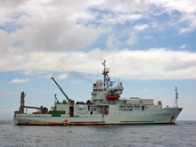
The R/V Thomas G. Thompson, measuring 274 ft in length and operating with a crew of 22, will remain at sea for 40 days during this cruise. Click image for larger view and image credit.
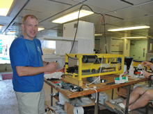
Chemical Oceanographer, Joe Resing, prepares a hydrothermal plume sensor for deployment with the DSL-120 sonar sled. Click image for larger view and image credit.
Underway!
December 3, 2005
Kelley Elliott
Web Coordinator
NOAA Office of Ocean Exploration
After several flights and a few short boat rides, all members of the science team have finally arrived on board the University of Washington’s R/V Thomas G. Thompson. Fair blue skies and calm Pacific waves greet us as we steam north from the Galapagos Islands to our research area. The first few days on board this cruise and many like it involve becoming familiar with crew and boat operations; unpacking; setting up, testing and adjusting equipment; and becoming familiar with shipboard safety procedures. Lots of preparations occur simultaneously as crew and science personnel rush to set up items for operation.
Co-Principal Investigator, Scott White, prepares software to collect and process data from the EM-300 multibeam system. Water column data must be collected using an XBT (Expendable Bathythermograph) sound velocity profiler, used to determine the depth of oceanic thermoclines, and incorporated into multibeam data collection and calculation for accuracy. DSL technicians prepare the sidescan and plume sensors on the tow sled for operation, while oceanographer’s attach sensors and water sampling bottles to the CTD/Rosette cast.
Behind these busy scenes at sea, lies a tremendous amount of time, work and preparation that has already been put forth by principal investigators and the chief scientist, Rachel Haymon. The inception of this cruise actually began in 2002 when Rachel first submitted proposals to both the National Science Foundation (NSF) and NOAA’s Office of Ocean Exploration. She had seen published reports on geophysical and petrologic studies that had been conducted in the region and realized the site provided a textbook location to study ridge-hotspot interaction. She contacted the previous researchers requesting images and data from their cruise in the desire to conduct further research. The response came - the researchers were willing and enthusiastic to share their work.
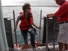
Rachel knew conducting research in the area would yield new and exciting results, and shed light on a geological interaction for which only supposition was known. She set about contacting the best people for the job - researchers from the University of South Carolina, hydrothermal plume experts from NOAA, and a number of researchers and students working with and around her at UCSB. She contacted technicians from Woods Hole Oceanographic Institution (WHOI) who she was certain would get the job done, and do it well. Ship time was arranged from the University of Washington, and she worked to obtain collaboration with scientists from Ecuador’s INOCAR.Chief Scientist, Rachel Haymon, takes her first step on board the R/V Thompson. Click image for larger view and image credit.
Rachel had been chief scientist on several cruises since the 1980’s, however putting this one together was by far the most difficult. She needed to conduct background work to prepare and submit proposals not once, but twice for two different agencies. Support came through in 2003, and finalizing arrangements for equipment, ship time dates, and the necessary personnel began, and continued as dates changed through 2005. Despite years of planning and a process that could at times be frustrating, Rachel’s hard work has paid off. She knows she has a GREAT team, and expects significant findings and accomplishments will be made by all. The initial EM-300 multibeam survey is scheduled to begin at 0400 with arrival at 89.5oW longitude.
Stay tuned to hear about our results!
Fast Fact
Did you know that the moon is mapped more completely and in far greater detail than most of the ocean floor?
Sign up for the Ocean Explorer E-mail Update List.


