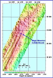
The first line of the EM300 (30 kHz) bathymetry survey over the main portion of Explorer Ridge. These data are mapped at 40 meter resolution. The map was used to determine the transponder positions, which ABE will be using for its high-resolution bathymetric survey (2 meter resolution or less). Click image for larger view.
Charting Explorer Ridge
June 30, 2002
Susan Merle
Geological Research Assistant
Vents Program
Pacific Marine Environmental Laboratory, NOAA
![]() Watch a 3D fly-through movie showing the seafloor at Explorer Ridge as mapped by the EM300 sonar system on board the R/V Thompson (mp4, 5.2 MB).
Watch a 3D fly-through movie showing the seafloor at Explorer Ridge as mapped by the EM300 sonar system on board the R/V Thompson (mp4, 5.2 MB).
Despite an anxious morning trying to resolve problems with the CTD system, today was a good start to the exploration of Explorer Ridge.
Late this evening, we have completed two striking swaths of multibeam bathymetry that is clearly superior to the older data in this area (see accompanying image). The new data reveals much greater detail of the fault structures and volcanic features of the shallow portion of Explorer Ridge. In addition, we now have a very accurate map of the area that we will use when we send ABE down for its first dive, which will probably be sometime tomorrow.

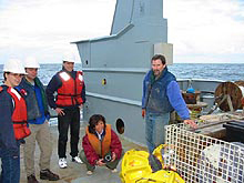
From left to right: Michelle Burkholder, Yannick Beaudoin, Maurice Tivey, Susan Merle and Bill Chadwick prepare transponders for deployment at Explorer Ridge. The transponders (yellow ball in foreground) are used for AUV and ROV navigation. Click image for larger view.
Late this evening, we will begin to deploy four “transponders,” which are undersea sound beacons that can be used to triangulate the position of ABE during its surveys. In addition, we just got word that the seas are calming down and that the CTD is fixed. Hopefully, tomorrow we will have some exciting news about the first deployment of ABE and the first immersion of the CTD into the hydrothermal plumes above the Explorer Ridge.


