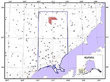
Location of the Next Generation Tools study area in the Bristol Bay region of the eastern Bering Sea. Side scan sonar evaluations were conducted in 12 corridors (shown in red), each approximately 100 m wide and 20 km long. Field operations were intentionally conducted in the rather pristine Red King Crab Savings Area (blue outlined area), because of the longstanding closure to commercial bottom trawling. Click image for larger view.
Project Summary
June 15 - July 15, 2001
Dr. Bob McConnaughey, Research Fishery Biologist and Project Chief Scientist
RACE Division, NMFS Alaska Fisheries Science Center, Seattle, WA
The distribution and abundance of invertebrate organisms residing on (epifauna) or in (infauna) the seabed, as well as the commercially-important species they support, are closely related to physical properties of the substrate. The Next Generation Tools expedition used a state-of-the-art Klein 5000 side scan sonar system and biological sampling to explore relationships between small-scale geological features and benthic communities in Alaskan waters. The primary objectives of the expedition were to evaluate advanced remote-sensing technology for future broad-scale seafloor mapping expeditions and the feasibility of using ships of opportunity for this purpose.
Interferometric side scan sonar technology was selected for this study because it is towed close to the seafloor and is thus uniquely able to detect subtle variations in seabed composition and morphology. The Klein system was used because its multibeam technology not only produces extremely high resolution imagery, but the swath bathymetry feature enables efficient collection of precise seabed measurements as well.

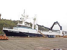
The F/V Ocean Explorer is a typical Alaskan trawler that fishes in the Bering Sea and Aleutian Islands groundfish fisheries. Click image for larger view.
An ability to use ships of opportunity for ocean exploration is highly desirable because availability of dedicated research vessels is limited. For this reason, a 155 ft commercial fishing vessel the F/V Ocean Explorer was chartered and modified to support the mission. Successful gear trials were conducted in Puget Sound (30 May-1 June 2001) and scientific systems were appropriately calibrated, thus confirming feasibility of the Alaska cruise plan.
The 31-day Alaska cruise began on 15 June 2001 when an exploration team of 13 scientists, technicians and commercial fishers departed Dutch Harbor, Alaska for Bristol Bay. The Bristol Bay study area is largely undescribed, despite the existence of valuable commercial fisheries and possible oil and gas reserves in the Bay. To further characterize the area and to address mission objectives, around the clock field operations were conducted on-site from 16 June through 11 July. The primary activities during this period were (1) side scan sonar surveys, ultimately covering over 500 nm of seafloor, (2) “groundtruthing” the side scan sonar images with 144 van Veen grab samples and occasional video camera deployments, and (3) biological sampling to characterize epifaunal (72 research trawls) and infaunal (144 additional van Veen grabs) populations.

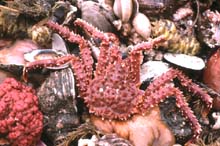
The soft-bottom environment in Bristol Bay supports a great variety of invertebrate organism that live on and in the sandy seabed. Approximately 150 different species were collected with trawls and grab samplers. Click image for larger view.
Preliminary observations at-sea are consistent with sparse data from nautical charts and fisheries surveys, indicating a relatively flat and sandy seabed that supports a rich invertebrate assemblage. The seafloor at 60 m appears to be brushed smooth, probably due to sizable storm waves and strong tidal currents that regularly disturb the area. Video images reveal greater complexity with at least some areas of the seafloor resembling the surface of a soccer ball with marbled coloration. A more detailed characterization will be possible once laboratory processing of the sonar and sediment data is completed. Significant numbers of derelict king crab pots were encountered in the side scan sonar images, as they continue “ghost fishing” for years after being lost to shifting winter ice packs. Two conspicuous as yet unidentified targets were also encountered.
In summary, the Next Generation Tools expedition explored benthic interactions at new spatial scales, while evaluating new technology for mapping physical, geological, chemical and biological aspects of the ocean environment. Visualization products are being developed to present mission findings in a format that is readily understood by all interested parties.

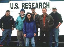
NOAA scientists and Navy technicians responsible for at-sea operations. Missing is a Navy navigation specialist, the captain and crew of the F/V Ocean Explorer, and a freelance video technician. Click image for larger view.
To date, we have validated the ship of opportunity concept by developing protocols for implementing state of the art side scan sonar and navigation technology on a chartered commercial fishing vessel. In the process, we have acquired high quality side scan sonar and swath bathymetry data with cm-scale spatial resolution which, combined with coordinated biological sampling, enables detailed characterizations of soft bottom benthic communities in the Bering Sea study area. Taken together, these accomplishments present a new opportunity for cost-effective broad-scale exploration and mapping of physical and biological attributes of the seafloor.
Sign up for the Ocean Explorer E-mail Update List.


