by Jason D. Chaytor, Research Geologist, U.S. Geological Survey

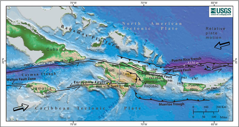
Figure 1: Map of the North American – Caribbean tectonic plate boundary. Colors denote depth below sea level and elevation on land. Bold numbers are the years of moderately large (larger than about magnitude 7) historical earthquakes written next to their approximate locations. Asterisk indicates the location of the January 12, 2010, Haiti earthquake. Barbed lines show the boundary where one plate or block plunges under the other one. Heavy lines with half arrows represent faults along which two blocks pass each other laterally. Image courtesy of the U.S. Geological Survey. Download image (jpg, 261 KB).
Puerto Rico, the Virgin Islands to its east, and eastern Hispaniola to its west, are located on an active plate boundary zone between the North American Plate and the northeast corner of the Caribbean Plate (Figure 1). The approximately 80 million year old Caribbean Plate is roughly rectangular, and it slides eastward at about two centimeters/year relative to the North American Plate. Motion along its northern boundary (in the plate boundary zone region) is dominantly strike-slip (sideways motion between the plates), with a small component of subduction (one plate sinks under the other plate). In contrast, the Caribbean Plate farther east overrides the North American Plate, creating the island arc of the Lesser Antilles with its active volcanoes. There are currently no active volcanoes in Puerto Rico and the Virgin Islands; the last volcanoes were active approximately 30 million years ago.
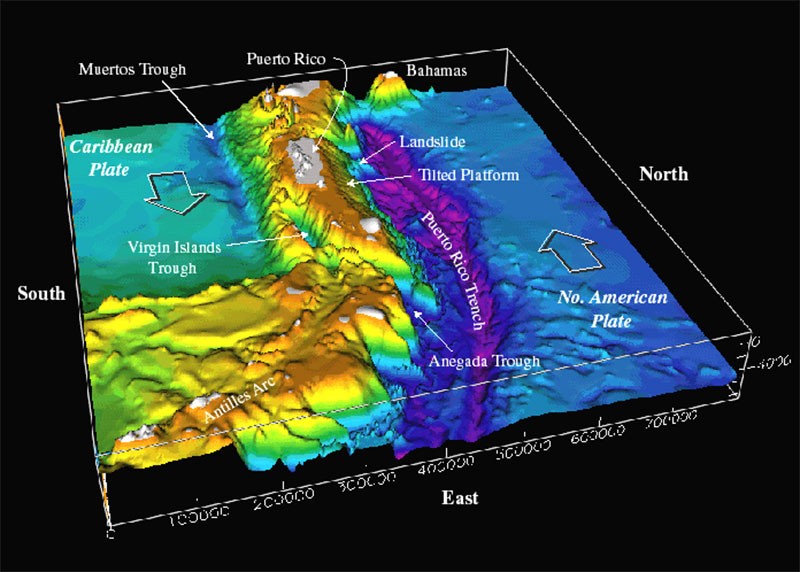
The Puerto Rico Trench (Figure 2) lies to the north of Puerto Rico and is the deepest part of the Atlantic Ocean, with water depths exceeding 8,300 meters (5.2 miles). Its depth is comparable to the deep trenches in the Pacific Ocean. Trenches in the Pacific are located in places where one tectonic plate subducts or slides under another one. The Puerto Rico Trench, in contrast, is located at a boundary between two plates that slide past each other with only a small component of subduction. The trench is less deep where the component of subduction is larger.

Figure 2: Bathymetry of the northeast corner of the Caribbean plate. Image courtesy of the U.S. Geological Survey. Download image (jpg, 198 KB).
The unusually deep seafloor is not limited to the trench, but also extends farther south toward Puerto Rico where a thick limestone (carbonate) platform, which was originally deposited in flat layers near sea level, is now tilted northward at a uniform angle. Its northward edge is at a depth of 4,200 meters (2.6 miles), and its southern edge can be found on land in Puerto Rico at an elevation of a few hundred meters.
South of Puerto Rico and the Virgin Islands, the Muertos Trough and deep sedimentary basins such as the Whiting and Virgin Islands basins further reflect past and ongoing tectonic activity. This long geologic history of plate boundary activity has created a complex undersea terrain that remains largely unexplored.
The region has high seismicity and a history of high magnitude earthquakes (Figure 1), including a magnitude 7.5 earthquake centered northwest of Puerto Rico in 1943 and magnitude 8.1 and 6.9 earthquakes north of Hispaniola in 1946 and 1953, respectively. Historically, other large earthquakes have also struck the area, such as one in 1787 (magnitude ~8.1), possibly in the Puerto Rico Trench, and one in 1867 (magnitude ~7.5) in the Anegada Trough south of the Virgin Islands.
The hazard from tsunamis in this region is also apparent. Immediately after the 1946 earthquake, a tsunami struck northeastern Hispaniola and moved inland for several kilometers. Some reports indicate that nearly 1,800 people drowned. A 1918 magnitude 7.5 earthquake resulted in a tsunami that killed at least 40 people in northwestern Puerto Rico.
Essentially, all of the known causes of tsunamis are present in the Caribbean – earthquakes, submarine landslides, submarine volcanic eruptions, subaerial pyroclastic flows into the ocean, and major tsunamis called teletsunamis. Because of its high population density and extensive development near the coast, Puerto Rico has a significant risk for earthquakes and tsunamis.
Caribbean Tsunami and Earthquake Hazards Studies
Puerto Rico Trench 2003: Summary
The Tectonic Setting and Geology of Puerto Rico and Its Surrounding Seafloor