by Dr. Jasper Konter, University of Hawaii at Manoa

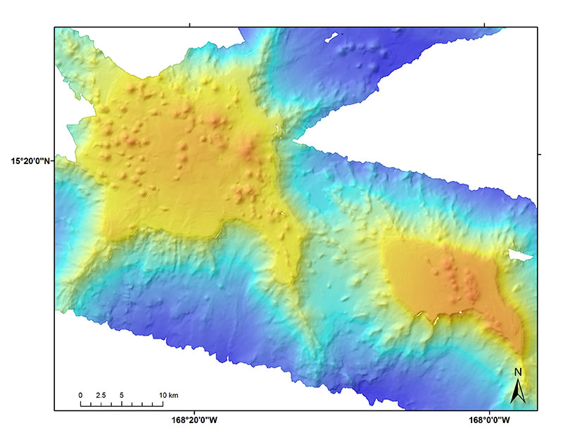
Two guyots just south of Johnston Atoll in the monument that have cone features on their summits. Image courtesy of the NOAA Office of Ocean Exploration and Research. Download larger version (jpg, 1.7 MB).
The central Pacific Ocean basin contains only a few islands, and they are spaced apart over large distances. These islands generally were built as volcanoes on the Pacific Ocean floor, growing from three miles deep to the ocean surface or further. Some of these islands are geologically young, such as the Hawaiian Islands, and include features such as volcanic craters and cones. Others islands are tens of millions of years old, and these islands are usually no longer clearly volcanic in origin. Instead, these islands commonly consist of white coral sand islands in the shape of a large ring, surrounding a central lagoon. This type of island is known as an atoll, the volcanic base is entirely submerged and covered in coral and coral debris (including sand). The atolls were originally also young volcanic islands that subsequently experienced millions of years of subsidence and erosion.
Most of the young islands were created by hotspot volcanism. In the hotspot volcanism model, a tectonic plate moves over the top of a stable hotspot, creating a trail of volcanoes as the hotspot burns into the plate overhead. As such a volcano moves further away from the hotspot, eventually volcanic activity stops, and the once hot volcano cools down causing subsidence, while it also erodes to sea level. While the volcano is near sea level, a coral reef can develop that will attempt to keep growing near sea level. Meanwhile, below sea level, another indicator of age develops in a growing layer of iron-manganese (Fe-Mg) crust, which builds up at about one millimeter per million years. Combined, these processes generate a chain of volcanoes with progressive coral reef (near surface) and iron-manganese (submarine) cover, an as these volcanoes age along the chain they eventually disappear under water. In the central Pacific Ocean, one of such chains of volcanoes is the Line Islands, which includes Johnston Atoll.

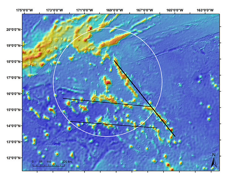
Main Line Islands seamount chain lineation (thick black line NW-SE) and two cross-trend seamount trails (thinner black lines that are E-W). Image courtesy of the NOAA Office of Ocean Exploration and Research. Download larger version (jpg, 3.2 MB).
The Line Islands, located between Hawaii and French Polynesia, contain a significant number of volcanoes that are partly visible as islands, but largely present as submarine volcanoes. Such volcanoes are known as seamounts. When viewed as a complete group of volcanoes, the islands and seamounts make up a more complicated chain of volcanoes than expected for a hotspot. The chain contains small groups or clusters of seamounts that trend across the main chain of volcanoes, which trend mostly north-south. Due to the remote location, the overall chain has only been sparsely sampled and characterized, and the exact origin of the complicated chain is still debated.
In addition to the presence of unusual cross-trending volcanoes, the age pattern observed is also far more complicated than that expected from the simple hotspot model. Some of the suggested models that might fit the complicated observations include creation of this chain of volcanoes through the presence of two hotspots that were erupting “downwind” or slightly offset but parallel from each other. This would generate trends following different directions of plate motion, related to the specific part of geologic time within which certain volcanoes were erupted and the specific plate motion direction of that time. More importantly, it would explain why there is no simple increasing age observed along the chain, but instead a more random pattern. As an alternative, extension along cracks in the plate underneath have been suggested, as these would still generate straight chains of volcanoes, but with no expectation of following a particular trend in ages.
With two general explanations for the existence of the Line Islands volcanic chain, further progress relies on a different approach to studying its volcanoes. Prior sampling has been mainly through dredging, and mapping has been very limited. New high-resolution mapping in the monument around Johnston has revealed many erosional platforms, particularly seamounts with flat summits known as guyots, which are not simply showing progressive subsidence. On top of these platforms, a number of the guyots show small cones that must have post-dated a major erosional period, and these cones and the platforms they sit on may provide a new way forward in the study of the Line Islands.
Davis, A.S., Gray, L.B., Clague, D.A., Hein, J.R., 2002. The Line Islands revisited: New 40Ar/ 39Ar geochronologic evidence for episodes of volcanism due to lithospheric extension. Geochem. Geophys. Geosyst 3, 1–28. doi:10.1029/2001GC000190
Epp, D., 1984. Possible perturbations to hotspot traces and implications for the origin and structure of the Line Islands. J. Geophys. Res 89, 11273–11286.
Garcia, M.O., Park, K.-H., Davis, G.T., Staudigel, H., Mattey, D.P., 1987. Petrology and isotope geochemistry of lavas from the Line Islands Chain, central Pacific basin, in: The Mesozoic Pacific: Geology, Tectonics, and Volcanism, Geophysical Monograph Series. American Geophysical Union, Washington, D. C., pp. 217–231. doi:10.1029/GM077p0217
Schlanger, S., Garcia, M., Keating, B., Naughton, J., Sager, W., Haggerty, J., Philpotts, J., Duncan, R., 1984. Geology and geochronology of the Line Islands. J. Geophys. Res 89, 11261.
Winterer, E., 1976. Bathymetry and regional tectonic setting of the Line Islands chain. Initial Reports of the Deep Sea Drilling Project 33, 731–748. doi:10.2973/dsdp.proc.33.125.1976