by Dr. Christopher Mah, National Museum of Natural History, Smithsonian Institution

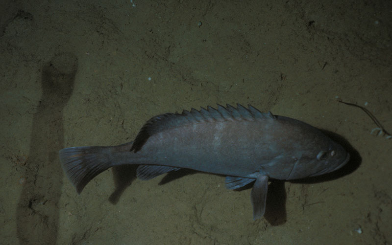
Figure 1: Hyporthodus quernus, a commercially harvested grouper that is only found at Johnston and the Hawaiian Archipelago. Image courtesy of the NOAA Office of Ocean Exploration and Research. Download larger version (jpg, 3.7 MB).
This NOAA Ship Okeanos Explorer expedition to the Johnston Atoll Unit (JAU) of the Pacific Remote Islands Marine National Monument, now known as Pacific Islands Heritage Marine National Monument, will potentially provide information relevant to a number of interesting biological questions that are currently being asked by both shallow water and deepwater researchers working in this area of the Pacific. Johnston Atoll is located approximately 700 miles southwest of the Hawaiian Islands. Its proximity begs a series of important questions, outlined below.
Many of Hawaii’s shallow-water marine faunas, including commercially important corals and fishes are thought to be endemic (i.e., unique to the archipelago). A very important component of understanding how endemism has taken place here is to understand how the ancestral species originally colonized the archipelago's many islands, atolls, banks, and seamounts.
Studies addressing these questions provide insight into understanding population diversity, which is particularly important to fisheries and monument managers responsible for managing economically important and protected animal species. For example, one study has shown where populations of the deepwater endemic grouper, Hyporthodus quernus (Figure 1), are most genetically diverse, the hypothesized archipelago entry point, as well as how these populations made it to Hawaii, is probably by going through Johnston Atoll. Results from this and similar types of studies raise additional questions such as what other factors make some areas more genetically diverse than others, what are the most vulnerable populations to fishing pressure, and how do findings like this impact future assessments of these species?

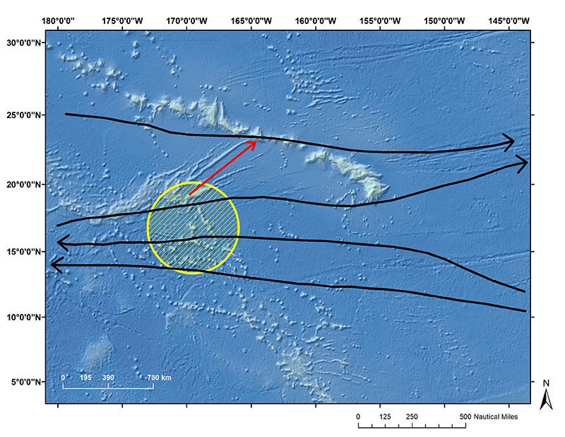
Potential dispersal routes connecting Johnston Atoll to the Hawaiian Archipelago. Black arrows are major current flow patterns and the red arrow is directly below Necker Ridge that could be serving as a seafloor bridge. Image courtesy of the NOAA Office of Ocean Exploration and Research, 2017 Laulima O Ka Moana. Download larger version (jpg, 3.5 MB).
A crucial step towards understanding how this colonization happens is based on the hypothesis that Johnston Atoll acts as a “stepping stone” or “gateway” for larval organisms, ranging from corals to sea cucumbers to fish, enabling them to settle and thus develop and become successful in the Hawaiian Archipelago. There is evidence that at least one other remote atoll, Kingman Reef, is a stepping stone into Hawaii as well.
Two major eastward moving ocean currents are no doubt part of the answer. The Subtropical Countercurrent and the Hawaiian Lee Countercurrent are thought to provide transport highways (remember Finding Nemo?) for larval fish and invertebrates (Figuew 2). South of the Hawaiian Archipelago is the westward flowing North Equatorial Current. These currents create complex channels for which different species can be transported into the Hawaiian Islands region. A third northeastern North Hawaiian Ridge current is present on the eastern side of the Hawaiian Islands. Thus, Northern versus southern regions of the island chain might be “fed” larval organisms by these different ocean currents.
In addition to the transport of marine larvae via ocean currents, the shape and presence of underwater ridges and other geologic structures may also play an important role. For example, Necker Ridge located just north of Johnston Atoll forms an underwater extension from JAU to the Hawaiian Islands. This ridge might physically facilitate transport of bottom faunas from this monument to the Hawaiian region. Thus, greater understanding of the geological history and the formation and architecture of these structures are of great interest.
Studying connectivity is accomplished primarily by studying either the genetics of different populations of animals and/or by researching the swimming larvae of marine species throughout the region in order to ascertain how they are distributed throughout the area and how genetically diverse they are relative to a specific region. However, noting the physical occurrence and abundance of species throughout the region as the Okeanos Explorer team has been doing has also contributed to solving this puzzle.
One big question for marine ecologists as well as those studying conservation and management is “How are animals distributed in the ocean?” which assists us in managing marine ecosystems and the important animals which live there. Knowing more about how fish live and breed for example, is important to understanding fisheries. Some corals provide habitats for fishes and so understanding one aids us in understanding the other. The deep sea presents a daunting challenge because of its vast size and multitude of environmental factors, including temperature, light, oxygen, pressure, salinity, nutrients and more.
One interesting research question the Okeanos Explorer team will address on this expedition is how the presence of oxygen in the deep sea affects the diversity and abundance of deep-sea organisms (mostly animals).

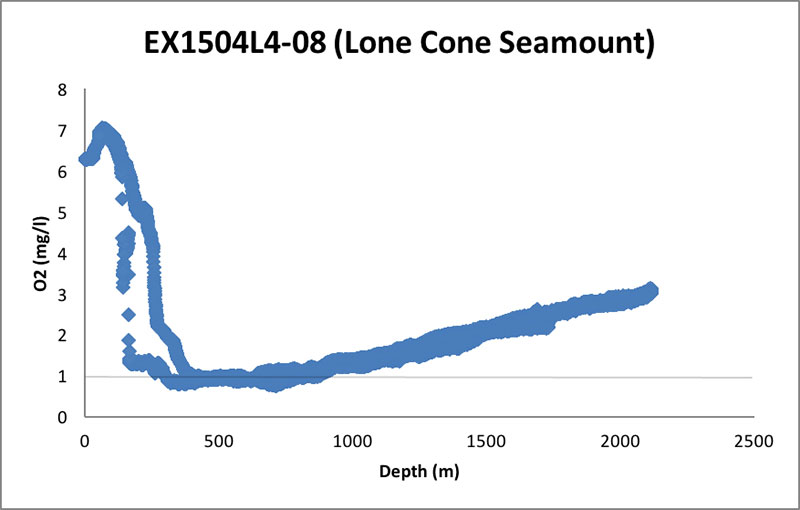
CTD oxygen data from remotely operated vehicle Dive 08 of Leg 4 of the 2015 Hohonu Moana: Exploring Deep Waters off Hawaiʻi expedition on "Lone Cone" seamount in JAU. Image courtesy of the NOAA Office of Ocean Exploration and Research, 2015 Hohonu Moana. Download larger version (jpg, 127 KB).
Even at great depths, oxygen remains a crucial gas for most animals’ survival, with some animals such as corals or sponges absorbing gases across their body surface while fishes which absorb oxygen across their gills. Oxygen concentration is a potentially important factor which might control for how animals are distributed along specific depth zones in the deep sea (Figure 3), both in terms of abundance (i.e., how many species are present) and in terms of diversity (i.e., how many KINDS of species are present).
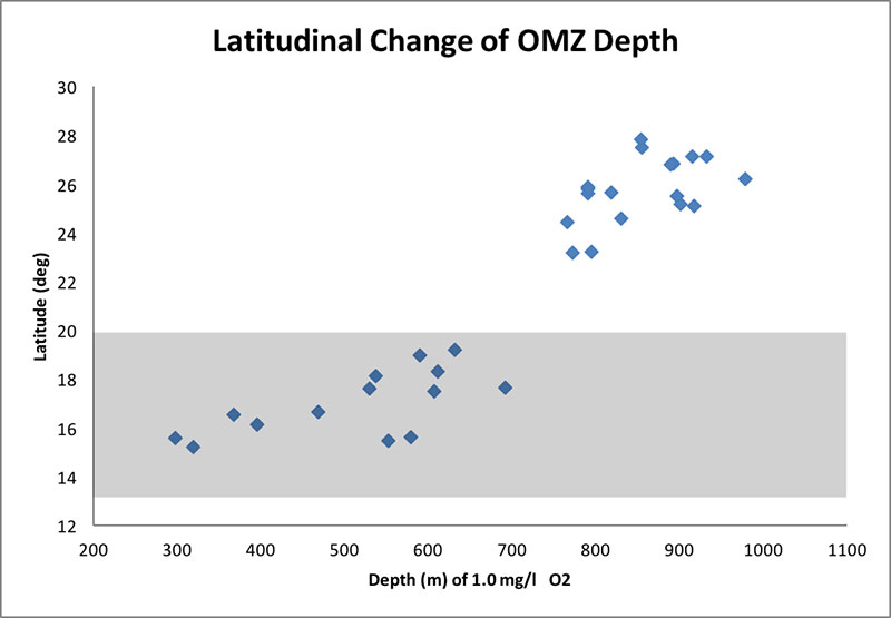
Based on data collected from prior work via the Okeanos Explorer, a latitudinal change takes place in the depth where oxygen levels are the lowest between Hawaii and Johnston Atoll. In particular, the “oxygen minimum” depth occurs at approximately 900-1,000 meters in the northern part of the Hawaiian archipelago, but at only 300 and 600 meters at JAU. Many animals can’t tolerate oxygen levels of 1.0 mg/l or less, so the communities found between 300 to 1,000 meters in JAU and Hawaii should potentially be different. Is that what we will find?

Figure 4: Latitudinal change in the depth at which oxygen levels are at 1.0 mg/l, here considered to be the insular equivalent of the Oxygen Minimum Zone (OMZ). The gray area is the latitude range for JAU. Image courtesy of the NOAA Office of Ocean Exploration and Research, 2017 Laulima O Ka Moana. Download larger version (jpg, 138 KB).
Our team on this expedition anticipates an engaging voyage centered around important scientific questions:
These questions have important implications not only for the fundamental scientific interest towards understanding this region’s rich marine fauna, but also in providing important data for fisheries and conservation managers to make decisions about ecologically and economically important species.