This expedition is part of the three-year Campaign to Address Pacific monument Science, Technology, and Ocean NEeds (CAPSTONE), an initiative to collect deepwater baseline information to support science and management decisions in and around U.S. marine protected areas in the central and western Pacific.
Amanda Demopoulos, research ecologist with the U.S. Geological Survey and co-science lead for the expedition, explains what makes the Pacific Remote Islands Marine National Monument, now known as Pacific Islands Heritage Marine National Monument unique and why building a better understanding of its ecosystems is so important. Video courtesy of the NOAA Office of Ocean Exploration and Research, Discovering the Deep: Exploring Remote Pacific MPAs. Download (mp4, 79.6 MB).

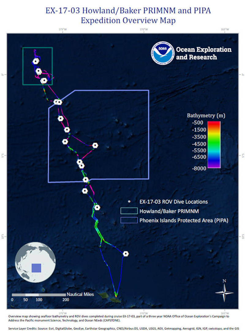
Overview map showing seafloor bathymetry collected and ROV dives conducted during the Discovering the Deep: Exploring Remote Pacific MPAs expedition. Image courtesy of the NOAA Office of Ocean Exploration and Research, Discovering the Deep: Exploring Remote Pacific MPAs Download image (jpg, 115 KB).
The Discovering the Deep: Exploring Remote Pacific Marine Protected Areas expedition was a 23-day telepresence-enabled expedition to collect critical baseline information about unknown and poorly known deepwater areas in the Howland and Baker Unit of the Pacific Remote Islands Marine National Monument (PRIMNM), now known as Pacific Islands Heritage Marine National Monument, American Samoa, the Phoenix Islands Protected Area (PIPA), and the waters around New Zealand's Territory of Tokelau. The goal of the expedition was to use remotely operated vehicle (ROV) dives and seafloor mapping operations to increase the understanding of the deep-sea ecosystems in these areas to support management decisions. Major accomplishments from this expedition are summarized below.
We know very little about the ecosystem dynamics of predation in the deep sea and how the food web actually fits together. By learning more about the kinds of deep-sea habitats and what predators these habitats can support, we are building knowledge needed to help managers make the right decisions to conserve resources for future generations. Video courtesy of the NOAA Office of Ocean Exploration and Research, Discovering the Deep: Exploring Remote Pacific MPAs. Download (mp4, 114.3 MB).
Conducted 19 ROV dives ranging in depth from 300 to 5,860 meters to survey the biologic and geologic variability of benthic habitats, including precious coral habitats, bottomfish fishery habitats, and manganese-encrusted habitats at seamounts.
Mapped more than 30,100 square kilometers of the seafloor.
This incredible "living wall" of crinoids, or feather stars, was observed during Dive 17 to explore on a steep slope along the western side of an unnamed seamount within the Phoenix Islands Protected Area, at a depth of +700 meters. Video courtesy of the NOAA Office of Ocean Exploration and Research, Discovering the Deep: Exploring Remote Pacific MPAs. Download (mp4, 21.1 MB).
Investigated a variety of different geological features including seamounts, atolls, manganese-encrusted seafloor, a deep trough within PIPA, and the waters around islands.
Sea pigs are deep-sea holothurians belonging to the family Elpidiidae. This sea pig was seen while exploring on March 24, during the deepest dive for the expedition, descending to 5,862 meters in a deep trough feature southwest of the Phoenix Islands. The anterior head end of the sea pig is on the right hand side and its back end is on the left. Video courtesy of the NOAA Office of Ocean Exploration and Research, Discovering the Deep: Exploring Remote Pacific MPAs. Download (mp4, 17.5 MB).
Collect more than 15 TB of data, including video and still imagery, multibeam sonar and single beam echo sounder measurements, subbottom profiles, current profiles, and CTD and dissolved oxygen measurements. All of the data from this expedition is publically available through national archives.
Engaged with the local community in Samoa, as well as audiences around the world.
An overview of some of the fish seen on the 19 dives on this expedition, while exploring the Phoenix Islands Protected Area and the Pacific Remote Islands Marine National Monument, now known as Pacific Islands Heritage Marine National Monument at depths ranging from 300 meters down to nearly 6,000 meters. Documenting fish at these varying depths can provide scientists with insights into the health and viability of an ecosystem. Video courtesy of the NOAA Office of Ocean Exploration and Research, Discovering the Deep: Exploring Remote Pacific MPAs. Download (mp4, 2.5 MB).