By Elizabeth Lobecker - Leg 2 Expedition Coordinator, NOAA Office of Ocean Exploration and Research
May 25, 2016

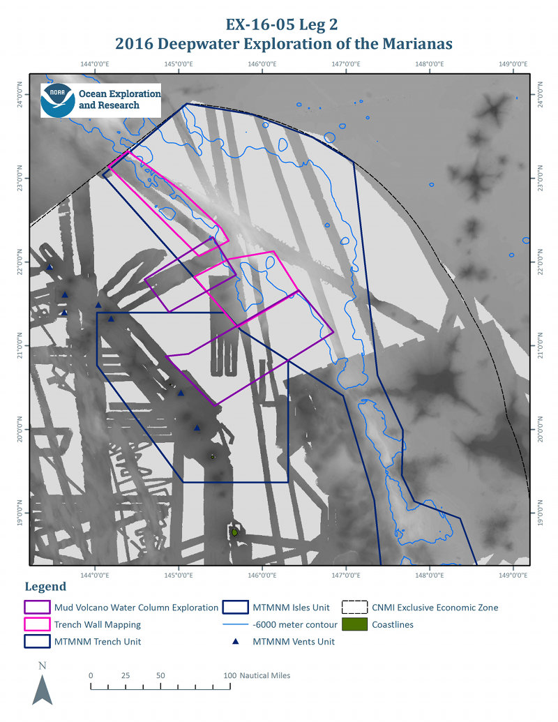
Figure 1: Map showing target mapping exploration areas for Leg 2 of the expedition. Image courtesy of NOAA Office of Ocean Exploration and Research, 2016 Deepwater Exploration of the Marianas. Download larger version (jpg, 2.1 MB).
Leg 2 of the 2016 Deepwater Exploration of the Marianas expedition is the second of three cruises focused on acquiring baseline data in deepwater areas of the Marianas Trench Marine National Monument (MTMNM), in order to support NOAA and partner science and management needs and to understand the diversity and distribution of deepwater habitats in the area.
Our efforts during Leg 2 will focus on the northernmost reaches of the MTMNM and Commonwealth of the Northern Mariana Islands, where currently only sparse modern, high-resolution mapping data exists.

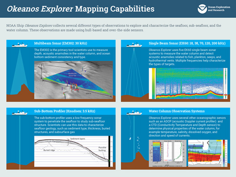
NOAA Ship Okeanos Explorer collects several different types of observations to explore and characterize the seafloor, sub-seafloor, and the water column. These observations are made using hull-based and over-the-side sensors. Image courtesy of the NOAA Office of Ocean Exploration and Research. Download image (jpg, 899 KB).
The Leg 2 mapping team, comprised of a combination of experienced seafloor mapping professionals and Explorers-in-Training (EiT), is ready to map the ocean floor 24 hours a day for the entirety of this cruise. This unique combination of experience levels ensures the efficient acquisition of high-quality mapping data in support of NOAA and partner goals, while also continuing efforts by the NOAA Office of Ocean Exploration and Research (OER) to train the next generation of ocean explorers.
Thoroughout the cruise, 24-hour-per-day data collection will occur with the ship's suite of sonars. With approximately 90 percent of Earth's seafloor remaining unmapped by modern sonar, this cruise make targeted and valuable contributions to global ocean exploration.
Since its first mapping cruise in 2008, NOAA Ship Okeanos Explorer has mapped over one million square kilometers and trained over 100 EiT's.
Sixteen large, active mud volcanoes are known to exist in the Mariana forearc, the area between the Mariana Trench and nearby volcanic island and submarine volcano arc1. Mapping operations will explore previously unmapped portions of the seafloor (see Figure 1, purple polygons) which have been identified by the scientific community as having good potential for the presence of new mud volcanoes. Additional information on the geology of mud volcanoes in the region can be found here.
The pink polygons in Figure 1 indicate where mapping efforts will focus on the western wall of the Mariana Trench, specifically the 6,000-meter depth contour. Generally, water this deep only occurs in ocean trenches, and few mapping systems can work this deep.
The 6,000-meter depth will push the limit of the ship's sonars ability to map the seafloor, and subsequent Deep Discoverer and Seirios remotely operated vehicle (ROV) dives based on this mapping data will push the ROV system's limits.
Additional information on how the Marianas Trench Marine National Monument was established under the U.S. Antiquities Act of 1906 can be found here.
The sonar data collected during Leg 2 will be used by onshore partners to choose and refine ROV dive locations for the next cruise, Leg 3. Throughout Leg 2, the OER streamlined data processing and transfer protocols will be used to send daily maps and mapping products to shore so that onshore partners can begin ROV dive planning efforts immediately.
1Fryer, P., J. Gharib, K. Ross, I. Savov, and M.J. Mottl. 2006. Variability in serpentinite mudflow mechanisms and sources: ODP drilling results on Mariana forearc seamounts. Geochemistry, Geophysics, Geosystems 7, Q08014, doi:10.1029/2005GC001201.