Heidi Hirsh - Natural Resources Management Specialist
May 11, 2016

This stunningly beautiful jellyfish was seen during Dive 4 in the Marianas Trench Marine National Monument on April 24, 2016, while exploring the informally named “Enigma Seamount” at a depth of ~3,700 meters. Scientists identified this hydromedusa as belonging to the genus Crossota. Note the two sets of tentacles — short and long. At the beginning of the video, you'll see that the long tentacles are even and extended outward and the bell is motionless. This suggests an ambush predation mode. Within the bell, the radial canals in red are connecting points for what looks like the gonads in bright yellow. Image courtesy of NOAA Office of Ocean Exploration and Research, 2016 Deepwater Exploration of the Marianas. Download larger version (jpg, 758 KB).
So far, the Deepwater Exploration of the Marianas expedition has been filled with great excitement, as there have been discoveries of new species and geologic features on nearly every remotely operated vehicle (ROV) dive. Having the Okeanos Explorer’s two vehicles – ROV Deep Discoverer and Seirios camera sled, working in tandem to broadcast live video feeds is not only exciting, but also invaluable in learning about what lies in and around the Marianas Trench Marine National Monument. It’s an honor to have the ship’s unique telepresence technology available for us to see every part of the seafloor they traverse. As managers, we join scientists and people from all over the world to attempt to identify what is being seen by the ROV.

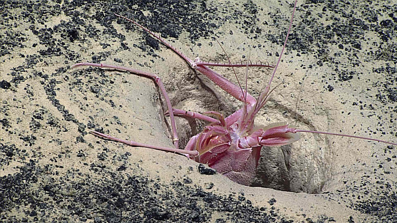
A huge blind lobster (possibly Thaumastocheles sp.) popping its head out of a hole on Dive 8. Image courtesy of NOAA Office of Ocean Exploration and Research, 2016 Deepwater Exploration of the Marianas. Download larger version (jpg, 2.0 MB).
Some goals of the Okeanos Marianas expedition are to characterize deep-sea fisheries, benthic habitats, submarine geology, and hydrothermal vents. How will we know what to protect, manage, and study, as directed in the Proclamation that established the Monument, if we don’t know what resources are found here? Thanks to the expertise of the Okeanos Explorer crew and ROV pilots, we’ve had the opportunity to see an unbelievably beautiful, never seen before species of jellyfish; ghost sharks; brittle-star-encrusted corals; galatheid squat lobsters; one gigantic lobster; black smoker chimneys; lava pillows; carbonate platforms; and the list goes on – see the daily updates and mission logs for more.
Leg 1 of the Deepwater Exploration of the Marianas expedition began off southern Guam and will end in Saipan. The goal of this leg was to map and identify resources in the trench, the volcanic arc, and the back-arc spreading center. Following a mapping expedition (Leg 2, May 20 – June 11), the Okeanos will spend Leg 3 (June 17 - July 10) heading north to the ridge, volcanic arc, and the 11,000-meter-deep Mariana Trench before finally returning to Guam. All of the videos, photos, data, and scientists’ initial collaborative findings will be analyzed and eventually shared so we can all learn more about this miraculous section of the deepest ocean on Earth.

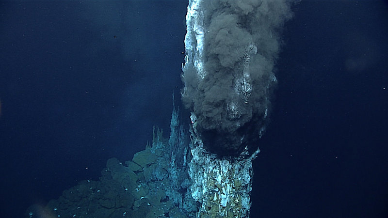
A “black smoker” on Dive 11. Where the super-hot vent fluid meets very cold ambient sea water (2°C) of the deep sea, minerals that are carried in the fluid precipitate out of solution, forming spectacular vent chimneys. We measured the temperature of the vent fluid at 339°C. Image courtesy of NOAA Office of Ocean Exploration and Research, 2016 Deepwater Exploration of the Marianas. Download larger version (jpg, 920 KB).
An unnamed seamount informally referred to as “Enigma Seamount” was visited during Dive 4 on April 24. This area was sampled because we think this seamount, along with others that lie along a northwest-southeast trend, may have formed on the boundary between the ancient Pacific Plate to the northeast and a much younger plate to the southwest. We hope the rock samples collected will help the scientists gain a greater understanding of the plate tectonic activity in the area of the trench. Information collected here and at other locations in and around the Monument will be used to inform the Mariana Trench Monument Management and Mariana Archipelago Science plans, which are evolving, living documents.
We look forward to the scientists’ continued collaborations on Legs 2 and 3 to discover new and unusual species, expand our knowledge of species’ depth and geographical ranges, and survey geologic features that give insight into understanding plate tectonics in this complex region. These new discoveries will help to decipher the creation of the seafloor and islands and connectivity of life on Earth.