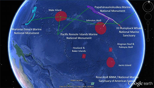

Map showing the completed 2015 operating areas (white lines), and planned operating areas (green lines) for the 2016 Campaign to Address Pacific monument Science, Technology and Ocean NEeds (CAPSTONE). Image courtesy of the NOAA Office of Ocean Exploration and Research. Download image (jpg, 46 KB).
NOAA Ship Okeanos Explorer explorations for 2016 began on February 18 and have thus far included work in the marine environments in and around the Papahānaumokuākea Marine National Monument (PMNM); Oahu; the big island of Hawai’i; and the area south and west of Molokai, Lana’i, and Kaho’olawe.
On April 20, the ship will depart from Guam to explore the deep waters of the Commonwealth of the Northern Mariana Islands (CNMI) and the Marianas Trench Marine National Monument (MTMNM) through mid- July.
This expedition is part of a three-year campaign focused on systematically collecting baseline information to support science and management needs within and around monuments and other protected places in the Pacific and serves as an opportunity for NOAA and the nation to highlight the uniqueness and importance of these national symbols of ocean conservation. Much of the monument area remains unexplored and our discoveries will help us learn more about the geological and biological phenomena found in the deepest oceanic trench on the planet.
Objectives for this expedition will include exploring enormous mud volcanoes, hydrothermal vents known as “smokers,” pools of liquid sulfur, streams of carbon dioxide bubbling from the seafloor, seamounts, dense apex predator populations, and spectacular coral reef systems – all the natural marvels for which the Marianas Trench Marine National Monument was designated.
What is learned from this expedition will improve our understanding of the deep ocean habitats of the Mariana archipelago, and of connections between seamounts, hydrothermal vents, and deep-sea communities.
This expedition will consist of three cruises:

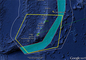
This figure shows the approximate operating area (yellow box) of the Okeanos Explorer for Leg 1. The white line shows the U.S. Exclusive Economic Zone and the blue shaded area is the MTMNM. Image courtesy of the NOAA Office of Ocean Exploration and Research. Download image (jpg, 27 KB).
Leg 1 (April 20 – May 11) will focus on carefully selected dive sites for the remotely operated vehicle (ROV) Deep Discoverer, and mapping areas in the southern half of the expedition area. ROV dive sites will be between 250 and 6,000 meters deep and are expected to include hydrothermal vent sites and deep-sea coral and bottom fish habitats.
Leg 2 (May 20 - June 11) will focus on mapping the northern half of the CNMI and the MTMNM, to include previously-unmapped areas of the monument, trench/subduction zone areas, and areas likely to host mud volcanoes.
Leg 3 (June 17 – July 10) will focus on selected ROV dive sites in the northern half of the CNMI and MTMNM, including areas that are mapped during Leg 2. Sites are expected to include mud volcanoes, trench/subduction zone areas and seamounts.
During this expedition, the exploration strategy of the Okeanos Explorer will be employed: bathymetric mapping using multibeam sonar; water column exploration using a Conductivity, Temperature and Depth Profiler (CTD); and remotely operated vehicle imaging and video. Scientists from around the world will be participating in the explorations in real time through telepresence technology and students and the general public can watch and listen to ROV dives in real time on the NOAA Ocean Explorer website.
Even as the importance of deep areas of the ocean in our everyday lives continues to increase, our knowledge of these areas remains limited. NOAA's Office of Ocean Exploration and Research is providing scientists and resource managers with access to basic information about deep-sea habitats and life forms so that they can prioritize future management and research efforts. This multi-year project will highlight the uniqueness and importance of these marine protected areas, both locally and to the world.