By Derek Sowers - Physical Scientist, NOAA Office of Ocean Exploration and Research

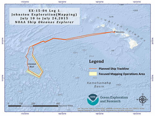
Cruise map showing the planned operations area for the initial mapping leg. The red line indicates the approximate trackline the ship will follow, and the yellow box indicates the priority area for focused ocean mapping operations. Image courtesy of the NOAA Office of Ocean Exploration and Research, 2015 Hohonu Moana. Download image (jpg, 101 KB).
This 15-day mapping cruise is the first of four legs between July and September comprising the Hohonu Moana: Exploring the Deep Waters off Hawai’i expedition. The expedition will involve mapping and remotely operated vehicle (ROV) operations in the deep waters of the Hawaiian Archipelago, including the Papahānaumokuākea Marine National Monument (PMNM), and Johnston Atoll – part of the recently expanded Pacific Remote Islands Marine National Monument, now known as Pacific Islands Heritage Marine National Monument (PRIMNM).
Mapping data and information collected during Leg 1 of the expedition will help address critical monument science and management priorities. This data will also help expedition team members identify targets for ROVs dives during subsequent expedition legs later this summer.
Beginning and ending in Pearl Harbor on the Hawaiian Island of Oahu, expedition Leg 1 encompasses an approximately 2,000 nautical mile loop to the remote Johnston Atoll area.
The Kongsberg EM302 multibeam sonar will be calibrated on the first day of the expedition by conducting a “patch test.” This test involves mapping an area of the seafloor from different directions and vessel speeds and ensuring that all of the sensors used to collect the multibeam sonar data are integrated correctly.
Following this calibration work, the ship will transit for three days from Oahu to the Johnston Atoll region, mapping a seafloor fracture zone and the Horizon Tablemount (a large flat-topped ridge feature) along the way. The ship will then spend approximately seven days mapping in the vicinity of Johnston Atoll, with a focus on the peaks and flanks of the Johnston, Hutchinson, and Karin seamounts and associated ridges. This will be the first time these massive underwater mountains have been mapped in detail with ship-based multibeam sonars. The last three days of the expedition will be spent transiting 680 nautical miles from the Johnston Atoll region back to port in Oahu. The ship will be in U.S. waters for almost the entire cruise.
Leg 1 is a mapping exploration cruise that involving 24-hour mapping operations while underway. The ship's sonar systems will be used to collect multibeam sonar, split-beam fisheries sonar, and sub-bottom sonar data will be collected continuously over largely unexplored regions that have never been mapped using sonar. This mapping work produces high-resolution maps of the seafloor and provides acoustic backscatter data information about the seabed and water column. This information will contribute to our understanding of the geological features and likely distribution of habitats within this vast recently-designated marine protected area.
Leg 1 will provide essential baseline mapping and reconnaissance of the region prior to the Leg 4 cruise that will return to the area this September. Mapping work on Leg 1 will enable scientists to choose dive locations for Leg 4, when we explore these deepwater habitats up close with the Deep Discoverer and Seirios remotely operated vehicles.
Engaging and training the next generation of ocean explorers is an important mission objective. Onboard this cruise will be four young scientists participating in our Explorer-in-Training Program . This program is open to enrolled undergraduate and graduate marine science students as well as those who have recently graduated from a higher education program.
A talented graduate student affiliated with NOAA’s Educational Partnership Program with a research focus on seafloor habitat characterization will also be onboard.
Joining the mission team on a NOAA Ship Okeanos Explorer expedition is a unique and highly competitive early-career opportunity, and the five individuals selected for this cruise will obtain exceptional hands-on experience in ocean exploration, at-sea research operations, and ocean mapping technology.
During the cruise, you can receive updates about the progress of our exploration work, and view live video streams showing the multibeam sonar mapping work in action, by checking our website.
All collected data on this expedition will be available in NOAA’s public data archives within 60-90 days of the conclusion of the cruise and can be accessed via the NOAA Ocean Exploration Data Atlas.