By Kelley Elliott, Expedition Manager - NOAA Office of Ocean Exploration and Research

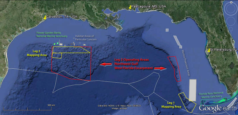
The 2014 Gulf of Mexico Expedition is divided into three ‘legs’ and includes operations on the continental slope and adjacent deep-water areas in the Northwest Gulf of Mexico and the West Florida Escarpment. Starting on February 24, scientists and technicians began mapping the seafloor using Okeanos Explorer’s deep-water mapping systems to acquire data in areas identified as high priority by the management community. Starting on April 10, Leg 3 operations will focus on exploring the diversity and distribution of deep seafloor habitats in the Northwest Gulf of Mexico and on the West Florida Escarpment using ROV Deep Discoverer and the Seirios camera platform. Image courtesy of NOAA Office of Ocean Exploration and Research. Download larger version (jpg, 591 KB).
From April 10 to May 1, a team of scientists and technicians both at-sea and on shore will conduct exploratory investigations on the diversity and distribution of deep-sea habitats and marine life in the Gulf of Mexico basin. The 59-day expedition, of which the April-May “leg” is a part, is composed of three ‘legs’ focused on acquiring data on priority exploration areas identified by the ocean management and interested science community.
Through discussions and information stemming from NOAA and the management/science community, priority areas have been identified in the Gulf of Mexico for focused mapping operations during Leg 1 and Leg 2. During this Leg 3, a number of exciting targets for focused remotely operated vehicle (ROV) exploration have been put forward during the final cruise of the expedition. In the coming weeks, we expect to explore cold seeps, deep coral communities, undersea canyons, shipwrecks, and perhaps even mud volcanos and brine pools.
The expedition also marks the second field season using NOAA’s 6,000-meter ROV, Deep Discoverer, and the Seirios camera sled and lighting platform on NOAA Ship Okeanos Explorer. When these seafloor observing systems are deployed from the ship, we will be able to provide scientists and audiences onshore with real-time video footage from deep-water areas in important, yet largely unknown, U.S. waters.