By Lindsay McKenna, Expedition Coordinator, Physical Scientist - NOAA Office of Ocean Exploration and Research

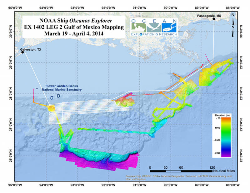
Map showing the planned area where the Okeanos Explorer will conduct mapping operations during the Gulf of Mexico Leg 2 Expedition. Image courtesy of ESRI, GEBCO, NOAA Okeanos Explorer Program, the U.S. Continental Shelf Project, and National Geographic. Download larger version (jpg, 3.6 MB).
On March 19, 2014, the NOAA Ship Okeanos Explorer will sail out of Galveston, Texas, to conduct exploratory seafloor and water column mapping in the areas south and southeast of Flower Garden Banks National Marine Sanctuary (FGBNMS), located in the northwestern Gulf of Mexico. Seafloor bathymetry, acoustic backscatter, and sub-bottom stratigraphic data will be collected continuously throughout the duration of the cruise. On April 4, 2014, the Okeanos Explorer will return to port in to Pascagoula, Mississippi.
Exploration of the region south of FGBNMS will produce high-resolution bathymetry and acoustic backscatter maps. These maps will provide critical baseline information to scientists and resource managers interested in identifying and expanding our understanding of important biological habitats and ecological connections in the northwestern Gulf of Mexico. Additionally, the data collected will help scientists better understand the size and character of seafloor habitats in the area, allowing for improved targeting of future exploration and research.
Ecological modeling suggests that this area has a high likelihood of containing deepwater coral habitat. The area may also contain biological communities associated with hardgrounds, brine pools, and hydrocarbon seeps. These habitats are often biological hotspots supporting a variety of fauna, including fish and invertebrate species.
Scientists can use the data collected during this leg and future cruises to explore the physical and biological relationships between the existing marine sanctuary area, shelf-edge reefs, and deepwater features. This may ultimately help conservation managers determine if shelf banks and deepwater habitats should be protected.
The NOAA Ship Okeanos Explorer conducts community-driven exploration, working with the ocean science and management communities to identify priority exploration areas and data needs. Mapping priorities for this leg of the expedition were identified considering input from NOAA's Flower Garden Banks National Marine Sanctuary, National Marine Fisheries Service Deep Sea Coral Research and Technology Program, National Centers for Coastal and Ocean Science, the Gulf of Mexico Fisheries Management Council , and gaps in contemporary, high-resolution mapping data.
Leveraging community input on priority exploration needs ensures the data acquired meets a broad range of user needs.
The data collected by the Okeanos Explorer during this expedition will provide baseline information about seafloor habitats and help improve our understanding of the ecological connection between mid-water and deepwater biological communities.
All collected data will be available in NOAA's public data archives within 60-90 days of the conclusion of the cruise and can be accessed via the NOAA Ocean Exploration Data Atlas.
Also see the Explorer in Training Program for Leg 2.