By Meme Lobecker, Expedition Coordinator, Physical Scientist - NOAA Office of Ocean Exploration and Research
EX1101 was NOAA Ship Okeanos Explorer’s first cruise of the 2011 field season. It was focused on ship shakedown and sonar patch testing in order to prepare for the coming field season. It provided an opportunity to get the ship underway and ensure that all of its systems and equipment were fully operational prior to integration of the ROV on board. Additionally, the cruise provided an opportunity to conduct bathymetric mapping to support the work of other NOAA offices and to select specific dive targets for use in ROV testing during subsequent cruises.

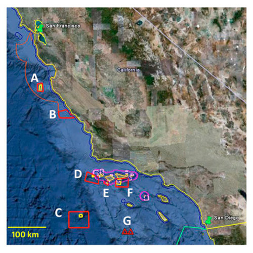
Screenshot from Google Earth showing EX1101 survey areas. Red outlines are overall survey areas, yellow outlines within red are priority areas as defined by ONMS. Pink borders indicate Channel Islands National Marine Sanctuary boundaries. Orange borders indicate Monterey National Marine Sanctuary boundary. Blue borders indicate California state water boundary. Turquoise border indicates US / Mexico EEZ boundary. A one kilometer bar is drawn for scale. Image courtesy of California Shakedown Cruise 2011: Exploring California's National Marine Sanctuaries. Download larger version (jpg, 2.9 MB).
Getting the ship ready for fieldwork after several months in dry dock is a complex challenge. The shakedown cruise provides an opportunity for the ship’s crew to ensure that all the equipment, machinery and gear are functional, seaworthy, and operating safely. It also provides an opportunity for the ships scientists to test and assess the performance of scientific equipment and instrumentation. During this cruise, the EM 302 (30 Khz) multibeam sonar, EA 600 (12 kHz) singlebeam sonar, and Knudsen sub-bottom profiler were tested.
This cruise also afforded the opportunity to conduct mapping in vicinity of Southern California after the ship shakedown objectives were met. The majority of the areas mapped were requested by other NOAA offices and integrated within the overall mapping shakedown objectives of the cruise. For this cruise, on board mapping personal collaborated with scientists from the Office of National Marine Sanctuaries (ONMS) to map the areas within Monterey Bay National Marine Sanctuary (MBNMS),the Channel Islands National Marine Sanctuary (CINMS), and an offshore area in the vicinity of San Juan Seamount. Additionally, the Center for Coastal Environmental Health and Bimolecular Research within the National Ocean Service, and the Southwest Fisheries Science Center within National Marine Fisheries Service jointly requested surveys over Hancock Seamount and “109” Seamount. Additionally, one archeological target was investigated within Gulf of the Farallones National Marine Sanctuary.

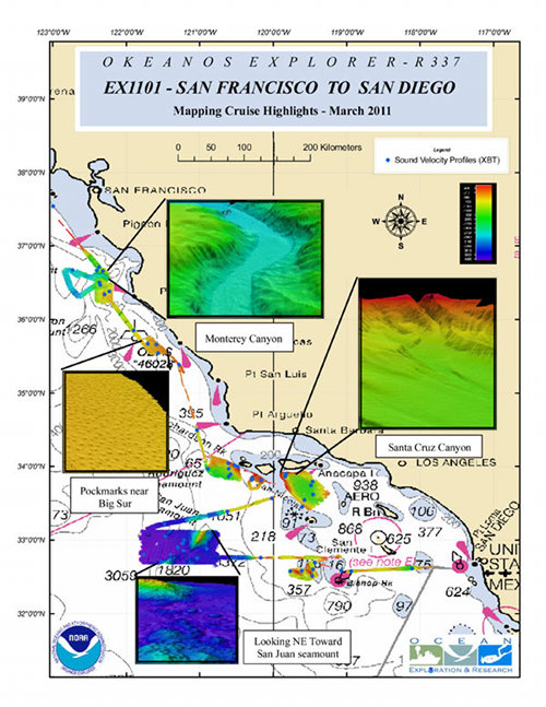
Figure 2: Cruise Highlights Map Sheet created in ArcMap by mapping watchstander Ash Harris, showing multibeam coverage and XBT locations collected during the cruise. Image courtesy of California Shakedown Cruise 2011: Exploring California's National Marine Sanctuaries. Download larger version (jpg, 3.0 MB).

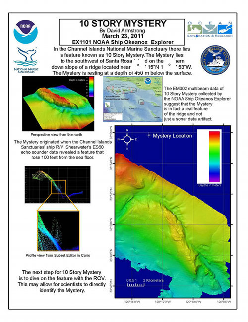
Figure 3: 10-Story Mystery one-pager created by Mapping Intern David Armstrong. Although ultimately the 10-Story Mystery was disproved, it provided an excellent testing and training opportunity during the cruise. Image courtesy of California Shakedown Cruise 2011: Exploring California's National Marine Sanctuaries. Download larger version (jpg, 2.9 MB).
EM 302 multibeam sonar performance was evaluated during this cruise and determined to be satisfactory. Given that environmental and instrumental errors impact portions of the swath coverage of the multibeam sonar differently, an optimal method for evaluating system performance is to run a number of overlapping survey lines in a procedure know as a patch test. After imaging the same “patch” of seafloor multiple times differences in each survey line can be isolated and attributed to environmental or instrumental errors which can then be documented and in some cases corrected for. This detailed assessment of the multibeam sonar at the start of the field season is necessary to document system capabilities, optimize settings for the season, and diagnose any problems arising from changes in hardware or software over the winter dockside period.